Blue Mountains ‘Grand Cliff Top Walk’ – Misleading Flyer & Press Release
In the Australian Blue Mountains, during the cooler months of June and July 2025, Nature Trail’s Tour Director, Steve Ridd, has decided to undertake a series of segmented practice reconnoitre trips (‘recces’) of the recently and mostly upgraded and renamed amalgamated hiking tracks branded the ‘Grand Cliff Top Walk‘.
This track is situated in the central upper Blue Mountains Region, and shown rather ‘high-level’ and indistinct on the only official government mapping provided to the public/tourists.
The New South Wales (state) Government’s recently named ‘Grand Cliff Top Walk’ (route shown in yellow) in the Blue Mountains, Australia. It is mostly a hiking track that covers about 20 km above the World Heritage Jamison Valley, politically re-branding 19 interconnected historic tracks, some dating back to the late 1800s. [SOURCE: ‘Blue Mountains, Blue Mountains Tourism, Winter 2024 edition, pp. 11-12.]
We tried the QR Code on the map above, which is indistinct. However, we can reveal that when scanned with a working smartphone QR Code app, it links to a tourism website VisitBlueMountains.com.au. This is the specific webpage link we found on that tourism website: ^https://www.visitbluemountains.com.au/travel/entry/grand-cliff-top-walk-itinerary
Nature Trail wishes to point out that it has no affiliations with the above website nor its owners, nor authors. Yet we point out that this link goes to a brief 400 word article entitled ‘Grand Cliff Top Walk Itinerary‘, that back in Winter 2024 promoted this ‘new walk’ on this tourist magazine’s website as written by regular travel writer Ellen Hill. The above hyperlink remains for anyone to read it.
We won’t reproduce the article for copyright respect, but while we acknowledge that it is another piece of excellent travel writing by Ellen Hill clearly purposefully to entice visitation, we do however flag some questions and concerns with the content.
We have decided to critique Ellen Hill’s article in a separate article of our own, following our professional current ‘ground-truthing’ reconnoitre of this ‘Grand Cliff Top Walk’ concept new trail.
Blue Mountains ‘Grand Cliff Top Walk’ – a misleading promotional article
This ‘Grand Cliff Top Walk’ is a newly partially upgraded continual hiking trail (track route), that amalgamates multiple historic and pre-named shorter designated tracks over a claimed 19.7 km hiking distance. The combined new trail’s distance approximates a Half Marathon (being officially 21.1 km / 13.1 miles).
Yet, it this trail is NO WAY a standard Flat Marathon, because it demands ascending and descending tens of thousands of stone steps throughout the trail, thus enlarging the actual hiking length due to elevation variations equivalent in aerobic exertion to being a full marathon (being 42.195 km/ 26.219 miles). [^SOURCE].
Many sections of this trail is very undulating and hilly along a narrow hiking trail (typically up to 1 metre wide) through dense forest and following mostly above a substantial (600 metre drop) clifftop escarpment in places; best characterised as being equivalent to a multi-staircase marathon, but was that the trail upgrade project’s intentions.
All photos included in this article were taken by the author on a reconnoitre undertaken on Friday 4th July 2025, unless otherwise stated.
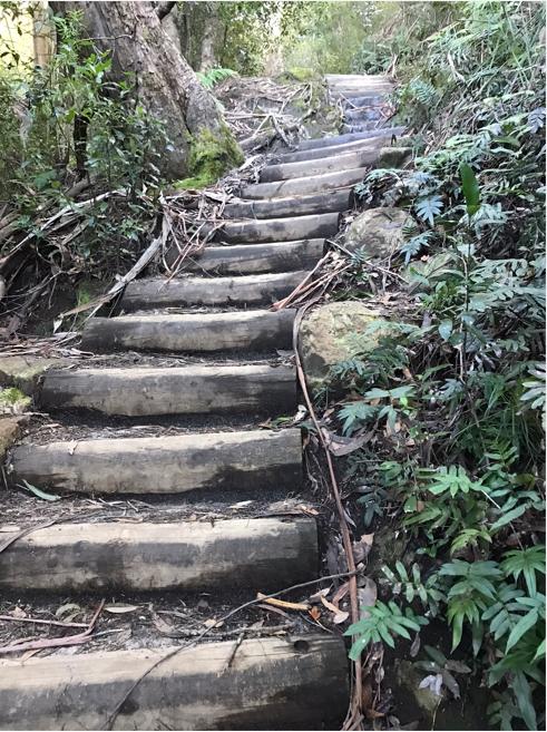
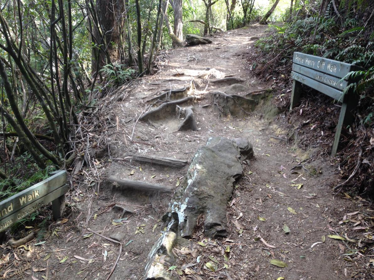
The trail staircases throughout ‘Grand Cliff Top Walk’ are unrelenting, and many sections remain yet to be upgraded and continue to present trip and slip hazards. So this unfinishedness makes the overall trail difficulty and risk more akin to a ‘Grade 4’ ranking than its promoted ‘Grade 3’. This is particularly due to the officially recommended 19+km in just two days/ [Photo by along Prince Henry Cliff Walk track’s old treated pine staircase section between Leura Falls and Kiah Lookout]
Nature Trail does not do 10+ km hikes in one day. Our competitors who may be uninterested in the interpretative Nature aspects of hiking, like bushwalking clubbers are welcome to undertake such stress heads-down and chattering all the way.
Instead, Nature Trail is focused on delving into Nature, with a capital ‘N’ out of respect for Ecology and our rejection of anthropocentric use and abuse of trampling native habitat and we greatly value access to established and carefully restored tracks through this Blue Mountains World Heritage Area.
Cynically however, we do consider this over-usage to be the conceived intention by the New South Wales Government during its Chinavirus pandemic lockdown regime to spend a considerable $10+ million. That money seems to have been not to restore existing tracks long-neglected, but instead to be driving some new marketing push to amalgamate, upgrade and interconnect multiple tracks into a new draw-card marathon running attraction. Charles Darwin Walk and Leura Cascades are still closed by Council after five years straight!
Local community and tourist industry consultation in all this is it COVID lockdown guilt excess? It’s not government funding, but public funding.
Then add another $2.4 million that was splurged by same to tart up this trail’s supposed mid-way pittstop at Gordon Falls Picnic Reserve (Leura) again funded by the NSW Government, this time out of its Western Sydney Infrastructure Grants Programme. So after budget blowout undisclosed a near $13 million fancy marathon track that few tourists will ever attempt trekking? A reasonable question by us as a local Blue Mountains hiking tour operator.
Government bureaucrats seem to bask in a perpetual loony quixotic fantasy bubble with mischievous intent. A 20km trail promoted to be undertaken in just two days is blatantly unsuitable nor appealing to everyday tourists to the Blue Mountains.
Rather, we suspect that instead this promoted new 20km marathon track is intended specifically for more marathons through the Blue Mountains World Heritage Area. In governmental language (having worked there) the NSW Government calls it “cost recovery” – that is it claims its $10 million lunacy will be recovered from charging fees to marathon organising corporations.
At times when such marathons are staged, the government locks out public access to such tracks – tracks that are publicly funded. The UNESCO listing of the Blue Mountains World Heritage Area back in 2000 was never intended for its abuse by large groups of marathon runners taking over tracks and trampling through precious Ecology for sport.
Can we expect track alerts by the Parks Service that the Grand Cliff Top Walk is not closed yet again due to landslips or upgrades, but for commercial marathons?
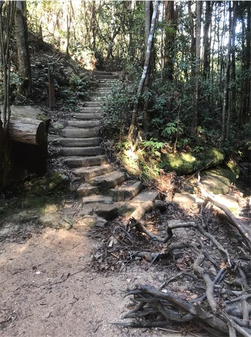
One of many old timber staircase sections of the ‘Grand Cliff Top Walk’ trail. This particular section is of the western side track in and out of the historic ‘Pool of Siloam’ feature from/to Gordon Falls Picnic Reserve. [Photo 20th June 2025.]
This hiking trail is not a ‘walk’, but we consider to be rather an extreme Grade 4 cross-country hilly marathon equivalent trail, given the Parks Service’s ridiculously promoted 2-day completion timeframe.
By trying to undertake this 19.7 km track in just 2-days, a hiker needs to be as fit as a young hyper-fit athlete, else risk not coping and health harm. We consider the NSW Government’s Parks Service on its public brochure promoting this ‘walk’ by showing a photo of a very young and inexperienced family trying it to be misguided and reckless.
That image:
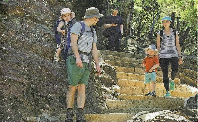
It ain’t a FLAT cliff top walk. It demands taking on tens of thousands of new ‘convict-picked’ style sandstone staircases up and down. This marathon trek is so totally unsuitable for toddlers!
As we write, it is over a year after this new fancy named trail was politically declared ‘OPEN’ by bureaucrats and their yes-folk over a year ago. This Grand Cliff Top Walk was publicly launched on 25th March 2024 as publicised and first noted in the Blue Mountains Gazette.
A media release by NPWS (National Parks and Wildlife Service of NSW – or as we call them ‘Parks Service’) was about its joint opening with local Council of some new ‘Grand Cliff Top Walk’ track along atop the Jamison escarpment.
Did any of these mob hike the track before the opening…or indeed since the opening? Or was it all for political PR showmanship? And they also had the gall to nick Nature Trail’s tour business logo in the process secretly without asking us – see circled post image below.
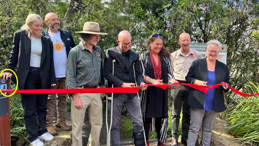
The grand bureaucratic ribbon-cutting opening of newly named ‘Grand Cliff Top Walk’ on 25th March 2024. Yet one surmises that not one of these folk in the photo have walked the entire track. [L-R: Artist Kelsie King, Gundungurra Elder David King, Parks Service employee (unknown), Council Mayor Mark Greenhill, Blue Mountains Local Member Trish Doyle MP, Blue Mountains Director of the NPWS David Crust, NSW (mega) Minister for Climate Change, Energy, Heritage and Environment Penny Sharpe, MLC (with the scissors). [^SOURCE]
But in truth, starting off by undertaking a due diligence ‘ground-truthing’ recce of this new mega-track during June 2025, Nature Trail has discovered that this fancy new track has at least six main shortcomings:
Six Main Shortcomings:
(1) The advertised ‘Grand’ track length of being 19.7 km is a substantial understatement. Its considerable rise and fall over many dozens of stairways makes its actual hiking ‘string laid out measurement’ far longer. Was the track professionally surveyed with a distance measuring wheel to verify the overall hiking distance? See sample below.

Lufkin Measure Wheel ‘Contractor 320mm’ [SOURCE: ^https://formdirect.com.au/lufkin-measure-wheel-contractor-320mm/]
We suspect not. We posit that the overall ground length of the Grand Cliff Top Walk it’s more like 22 km. Was the Sublime Point/Willoughby Roads walk of ~1km included in the 19.7 km? If not, that’d make the overall ‘hiking’ distance more like 23 km!
(2) We consider that reasonably such a hiking distance is patently excessive for most regular hikers. So to promote that it be attempted in just 2 days is in our opinion a gross downplay of reality. Yes, a marathon runner could like accomplish that feat – but a Flat Marathon runner?
(3) Very little proportion of this ‘Grand Cliff Top Walk’ is indeed along any clifftop. Based upon the Parks Service flyer, (hiking direction east to west), the Charles Darwin Walk follows a creek line, not a clifftop. This the same from Conservation Hut to the Fairmont Resort and onward to Gordons Falls Picnic Reserve. So this translates to the first half of the Grand walk being distant from clifftops and any clifftop vistas no existent. So, how misleading?
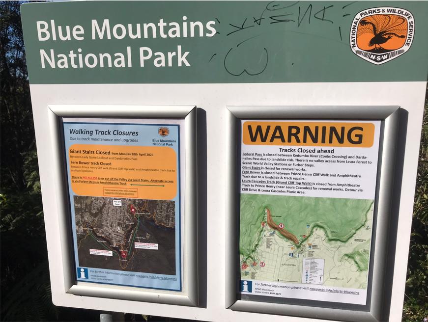
(4) This ‘Grand’ track still isn’t finished nor open to the public in at least three sections thus far – based on our actual recces the past few weeks. On track, checking the track out, we have confronted multiple sections of this track remaining closed off to public access and some for many years. So this new highfalutin ‘Grandious’ prop AIN’T OPEN dudes!! A lot of it is yes upgraded, and so noted and gratefully acknowledged, but it’s still not ‘ribbon-cutting’ ready still a year later in July 2025, let alone back in ribbon-cutting March 2024.
(A) Charles Darwin Walk (Fletcher Street to Weeping Rock) – this imposes a hiking off track detour along local streets through Wentworth Falls (Fletcher Street and Falls Road) requiring hikers to walk on roads due to the absence of footpaths. This poses a serious pedestrian risk.
(B) Prince Henry Cliff Walk (Gordon Falls Picnic Reserve to Elysian Rock) section is closed as at June 2025, and has been since 2020 (so 5 years!!).
So, a valid question is why has this infrastructure project been launched by Council and the Parks Service since 25th March 2024, when it had not been fully opened? What message does a high profile publicity campaign in the media and marketing materials whilst still a half-baked cake?
(C) Sublime Point Road – a ~1km section between the Fairmont Resort and Golf Links Lookout requires hikers to walk along a tourist-busy Sublime Point Road lacking footpaths; so presenting another serious pedestrian risk incumbent upon Council’s public risk liability.
The new default template signage of the Parks Service – like, ready for next week, in case of (A) Upgrade, (B) Landslip, (C) Marathon.
(5) As a Parks Service promoted 2-day trek, this track is suited only to younger, highly fit experienced hikers carrying little pack weight. It is not suited to the majority of hikers who visit the (upper central) Blue Mountains for a day or two. So the nearly $13 million upgrade funded by the NSW Government on this newly named Grand Cliff Top Walk, in our opinion has been bureaucratically misdirected away from more pressing track repair priorities. The funding has been instead dedicated to a some new concept trek suitable for a demographic that comprises a tiny fraction of the hiking usage – tourists and locals alike.
The much overdue priority track repairs, and upgrades, of existing but closed shorter and historical hiking tracks have been neglected. Many track closures of popular historic tracks prevail after many years and decades.
Our current check of closed tracks across the Blue Mountains National Park alone are listed as follows:
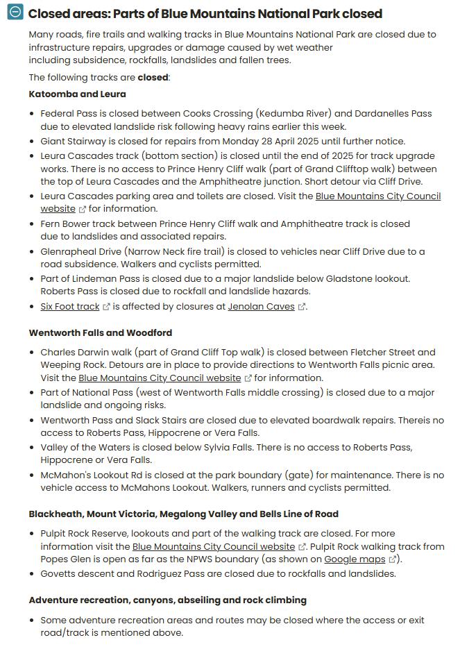
Source: Current alerts in this area Last reviewed: Fri 4 July 2025, 3.12pm, NPWS ^https://www.nationalparks.nsw.gov.au/visit-a-park/parks/blue-mountains-national-park/local-alerts
(6) The transport/transfer logistics have not been considered, that is if this trail was intended for independent hikers and hiking groups. The location of this track is poorly serviced by public transport.
The only points along this track service by public transport nearby are at the start (Wentworth Falls Railway Station) and from Echo Point. Good luck at Gordon Falls Picnic Reserve, unless hikers are content to pay $22 each catching the privately run tourist Explorer Bus to get back to village centres at Leura or Katoomba.
As a previous bus/coach/Trolley driver, Nature Trail’s Tour Director, Steven Ridd, can confirm that the last daily public bus pick up time from the trail end at privately run Scenic World is currently 3:35pm (Mon-Fri) as a “temporary stop”), 4:35pm (Sat, Sun/Public Holidays). If you miss the last bus then you’ll need to book a taxi (good luck waiting), else walk the 2.5 km back uphill to Katoomba.
So much for the recommended drinks at Scenic World’s Terrace Café (Bar) – it closes at 4pm (Mon-Fri), else at 5pm – per below from Scenic World website.

As an aside:
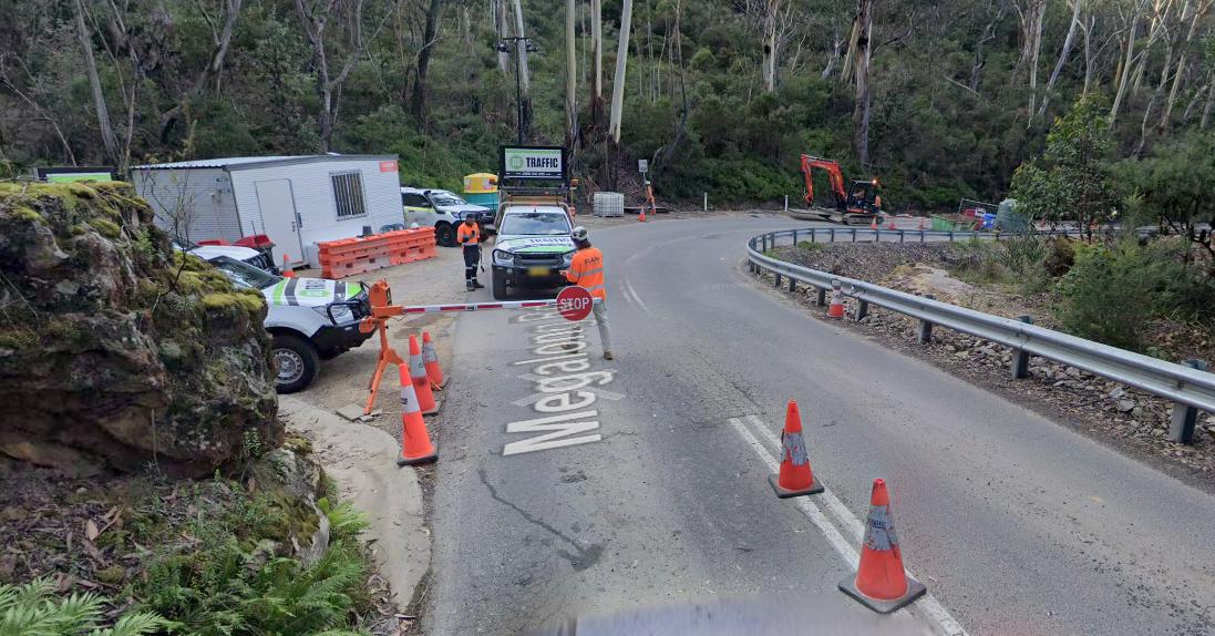
Blue Mountains Council has a reliably ‘unreliable record’ of announcing its project completions before they are indeed completed. For instance, consider its Megalong Road catastrophic landslip remediation project. The following is Council front page propaganda to ratepayers in its Community Newsletter of April 2025.
 Loading...
Read it!
Firstly, the above press release is contradictory. The editorial heading states:
“Megalong Road restored ahead of schedule”.
Yet, in the text by the author it states:
“Further remediation works are ongoing, with some stop and go traffic controls necessary. Work is due to be completed in May 2025 (weather permitting).”
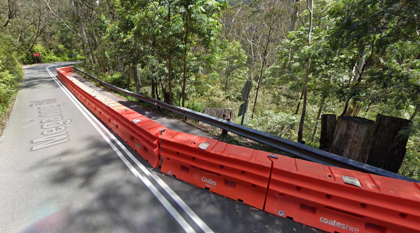
Megalong Road still in March 2025. [SOURCE: Google Maps, Street View, March 2025]
Go figure!
It’s ‘tail before the horse’ stuff. Marketing completion before operational completion.
Now, if visitors and tour operators alike entrusted Council’s public notice of this road being “re-opened”, such unexpected discovery during a trip could throw plans into disarray.
Access to Council roads is all ‘hit and miss’ – such as Leura Cascades Picnic Area and associated vehicular access to the track head – continually closed to the public since February 2020. But then Council is hardly tourism friendly.
Secondly, the cause of this latest landslip along Megalong Road, located about 100 metres downhill of the previous one in March 2021, had been the lack of culvert under the sandy road ‘subgrade‘ (i.e. the natural ground beneath a road, upon which the road bitumen pavement is built).
Council was well aware from March 2021 of this second damaged section of Megalong Road, as it was at that same time pre-occupied remediating the major one further uphill on the sharp bend. It just put this crash barrier in place and left it for three years.
Then another downpour over 4th-5th April 2024, so with still no culvert under the road, this happened to this same crash barrier…
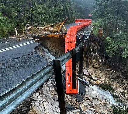
“..a foolish man who built his house on the sand…” [SOURCE: The Holy Bible, New Testament, Matthew 7:24-27].
It is a repeated and management cultural problem of Blue Mountains Council, to ignore infrastructure maintenance responsibilities (e.g. council roads and stormwater) such that major structural failures are allowed to occur. Then Blue Mountains Council goes hand in glove to the NSW Government pleading for capital grant funding. Meanwhile, the landscape is steadily undermined, plus locals ratepayers and tourists suffer ongoing closures.
Nature Trail’s Tour Director and Blue Mountains resident and ratepayer, Steven Ridd, has witnessed this chronic problem scenario being repeated since 2001.
Steven, being a local of Katoomba in the Blue Mountains since 2001, and a keen hiker here since 1993, has hiked this track, previously most of it named Prince Henry Cliff Walk (track) a number of times. The Prince Henry Cliff Walk track traditionally runs from Gordon Falls Picnic Reserve westward to Scenic Railway (now Scenic World).
Prince Henry Cliff Walk since completed in 1936, remains “still in use today’s text, local usage or on maps” according to the Upper Blue Mountains Geographical Encyclopaedia (2001).
That is unless the joint government custodians of the Natural forested landscape that this tracks passes through (the Parks Service and Blue Mountains Council) have officially renamed it. That process has not been made public and there has been no local community consultation about such a name change. It would represent a cultural cancellation of Australian history. Many features across the Blue Mountains have eponymous links to British Royalty.
The following reference reveals the origins of Prince Henry cliff Walk.
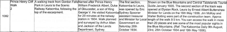
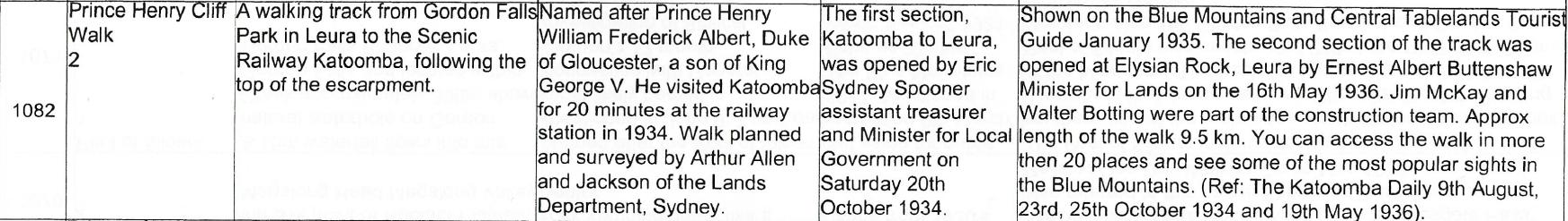
SOURCE: [10] ‘Prince Henry Cliff Walk‘, (feature 1082), in printed book ‘Upper Blue Mountains Geographical Encyclopaedia’, 2nd Ed, 2001, by Brian Fox, Bathurst, ISBN 0 9578737 1 9, p. 134
Note above the stated distance of the Prince Henry Cliff Walk track being 9.5 km, which is the very same part of the now Grand Cliff Top Walk trail part and exact same route.
So the 7.7 km signage (below at the original start at Gordon Falls) has been understated in the current official marketing literature by 1.8 km. This means that the overall Grand Cliff Top Walk trail of 19.7 km is also understated by 1.8 km, so making it in fact 21.5 km i length. And we believe that is, at least. No professional survey of the distance has been conducted.
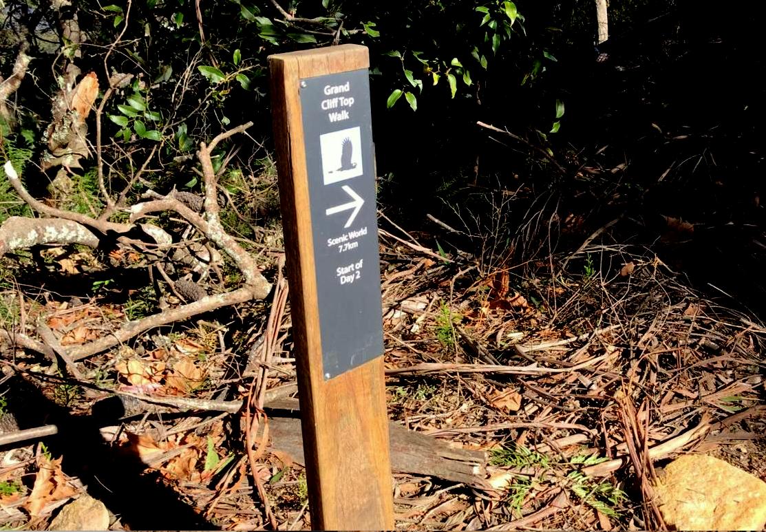
Our ground-truthing: The wayfinding signpost of the ‘Grand Cliff Top Walk’ at the Gordon Falls Picnic Reserve for “Start of Day 2” to head westward, shows the finish to be “7.7 km to Scenic World”. Really?
Rubbish! This again understates the historical record (per above source) of the original Prince Henry Cliff Walk that takes the exact same track route from this exact same track start to the exact same track finish along this same cliff top. Go figure!
Over many decades of late, the Prince Henry Cliff Walk had been neglected and left unmaintained and so over the years had become dangerous to tripping and slippage (exposed tree roots, worn steps due to overuse over a century of hikers). Thus as a responsible tour operator, Nature Trail subsequently and sensibly had decided to previously avoid using this track for its commercially hiking tours over such poorly maintained track sections.
Re-branded ‘Grand Cliff Top Walk’ in a section prior in 2017, when for the most part this track was constructed between 1934-1936 during The Great Depression by unemployed younger men, paid by the government. The track is historically named the ‘Prince Henry Cliff Walk’ after British Royalty. It extends from Gordon Falls Picnic Reserve in Leura to then Scenic Railway in Katoomba).
The new ‘Grand Cliff Top Walk’ is basically a re-branded the historic Prince Henry Cliff Walk for the most part, plus adding extensions to connect the classic Charles Darwin Walk to feed into Scenic World’s mass tourism enterprise in Katoomba, nearly a 20 km hike away.
The long track passes through a mix of Blue Mountains Council managed in custodianship for the Blue Mountains ratepayers, and also managed in custodianship by the NPWS (‘Parks Service’) for the State of New South Wales – supposedly mostly to protect its wildlife and native habitat, apparently under the likes of rotating unqualified pollies and bureaucrats, Matt Kean, Penny Sharpe, Anthony Lean, Atticus Fleming, and David Crust, et al.
Yet, the Parks Service (NPWS), in its infinite sheltered workshop wisdom, recommends ordinary tourists to the Blue Mountains ‘National’ Park can do this trek in just two days. What were they thinking? I bet none of them has done the track and certainly not in their recommended two days. Epic idea on paper, but misguided, disingenuous, naïve, unwanted, inappropriate and high risk. Decision making massive fail?
The Parks Service has become more about anthropocentric usage moreso than wildlife protection.
Here’s Parks Service first released flyer, done in closed-door cahoots with local Blue Mountains Council. We’ve copied this flyer and made it publicly downloadable (given its about public lands), and since that is what Parks Service and local council have done to our copyrighted business logo.
Loading...
Such a track flyer is misleading marketing by the NSW Government, because it is certainly not a 2-day trek for normally fit visitors as if it is a ‘walk in the park’; on track emergencies are waiting to happen!
Rather why not try a more realistic and manageable 7-day trek for most visiting hikers? What proportion of visitors to the Blue Mountains are interested in undertaking 19.7 km trek over just two days?
Ok, so first consider the map provided by the Parks Service. It is only made publicly available on a part of its its double sided A4 flyer, which is 20cm (wide) x 9cm (high). The 20cm covers about 7.5km as the crow flies, making it a map scale approximating 1:25000, which is comparable with the standard topographic map of the area.
Yet the details are scant. It’s so tiny as to be unreadable without a magnifying glass. The map legend is useless and the scale is bizarre – distance increments of 200m are useless; far better to simply display 1km as indicative.
At least the north indicator is to the top of the page, unlike a number of Parks Service on track maps which instead choose relative position to the viewer on the track, like North being downward. The map is to tony to add any topography, so for instance the track ascents/descent are unknown, which is misleading to unfamiliar visitors whom so presume it is a ‘cliff top walk’, so along the cliff top. But it is certainly not! Half the route is not along a cliff top – the Charles Darwin’s Walk segment and from Conservation Hut to Gordon Falls Picnic Reserve segment.
Our rating of the official micro map? Say 1/5.
A dedicated larger scale and sized saleable topographic map for this entire track (with more useful details for hikers and sealed to avoid rain damage is highly recommended – to be sold by both Parks Service and Blue Mountains Council.
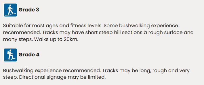
And how absurd is this distance? Day 1: 11 km | Day 2:8 km – both rated at Hiking Grade 3. But having started this track I consider this track grading is understated. In my view this track is at least Grade 4 on track, not on paper from an office.
SOURCE: Australian Walking Track Grading System, ^https://www.nationalparks.nsw.gov.au/safety/bushwalking-safety/australian-walking-track-grading-system
That is unless you’re a hyper-fit 20-something year old athletic marathon runner, replete with a backup support team throughout! The Sydney City2Surf is 14km, so lesser than a 21 km half-marathon. It holds a sad history of heart attack participant victims (‘heartbreak hill’) until the organisers re-scheduled it from September back to August in Sydney’s cooler winter.
But this so-called Grand Cliff Top Walk is far worse because most marathons are flat, that is, mainly running on flat ground, where one can achieve a constant running rhythm and pace.
This new Grand Cliff Top Walk is categorically from my experience NOT suitable for most ages and fitness levels to trek over a continual track stairway for 20km in just 2 days.
The only dodgy exclusion by the Parks Service not to deem this track as rated Grade 4 difficulty is by its extensive signage funded by the NSW Government – plagiarising Nature Trail’s logo in the process.
However, this monster is all about steps, staircases up and down – it seems never ending. So my “half-marathon” comparison is quite an understatement, having now tried it personally section by section. I am currently ‘ground-truthing’ the full length of this particular track. It’s during colder winter, not in sweltering and humid summer, which would, in my view pose serious exhaustion risks.
Parks Service’s recommended 2-day completion schedule is utter fantasy, misleading and dangerous, especially showing young families on its flyer for the PR, as if “this track is a breeze”.
So, beware! This track’s purported 19.7 km hiking distance comprises continual high-rise scale staircases up and down, one after the other. The starting Charles Darwin Walk section is just a flat lure, thereafter be warned! The extent of the repeating ascent/decent undulation of this amalgamated track to complete in the recommended 2-days requires the health, aerobic fitness, stamina, leg muscular strength to undertake a full marathon equivalent of 42 km.
It wouldn’t take much at all for the Parks Service to certify its combined new track distance into an officially recognised Half Marathon (21.1km), by it extending this new track from 19.7 km by 1.4 km to meet the 21.1 km standard.

…and this was just a FLAT marathon!!!
And if you don’t start this track at dawn, you most likely won’t Day 1 make Gordon Falls before sunset!
As an aside:
Back in the 1990’s, I whilst working in corporate Sydney CBD midweek in The Grosvenor Place tower high-rise building on George Street, as an active and fit 30-something-year-old, before work every day I gymed Coogee Surf Club an hour and swum 1 km across and back Coogee Beach bay.
I then used my lunch break to cardio the fire escape. I changed into shorts and singlet (Sydney’s weather is typically hot with high humidity), and took the lift down to the ground floor then climbed the 44 flights of stairs (+ an extra level to the roof door) and then back down to the ground and then showered, changed into corporate attire, before going back to my work desk. Many others went to a nearby food court and ate their lunch at their desks – think the 1987 film ‘Wall Street’ culture.
Sydney’s Governor Place (centre), cnr George and Essex Streets
The reason I refer to this experience, is that when much younger I used to be very fit, and not unfamiliar with hiking and trekking down and up the Jamison and Grose valleys. I could do the length of Katoomba’s Giant Stairway down in 7 minutes and back up in 14 minutes.
Clause, now as a 61 year old, I am not as fit. However, I wish to impart to readers that such a stair climb up and down Grosvenor Place resembles a fraction of this ‘Grand Cliff Top Walk’ intense marathon. Perhaps, Grosvenor Place x6!!
Some initial comments and questions:
(1) Frankly, this new multi-million dollar 20 km marathon-scale track that no one asked for, is another misspent extravagant $10+ million project wasting taxpayers’ money yet again.
There are so many more beneficial repair projects needed across the Blue Mountains Region more deserving of such vital funds.
Here’s a few more important tourism projects desperately overdue for the Blue Mountains:
- Protect watercourses across the Blue Mountains World Heritage Area from urban stormwater pollution
- Leura Cascades Picnic Area upgraded and re-opened, including all the connected track repairs. This was a vital track head hub for many track options, yet has been closed since 2020, due to local council stormwater mismanagement
- Remove Transport for NSW (P2P) extortionate fees and red tape on tour operator vehicles – $120 to apply then currently a $633 annual authorisation fee, even if no passengers, as in through NSW Government lockdowns, plus a taxi levy!
- Stop NSW Government railway ‘trackwork’ timings clashing with major events in the Blue Mountains
- Dedicated and perpetual financial and marketing backing by the NSW Government jointly with local Blue Mountains Council of key annual tourism drawcard events – eg: Winter Magic, Music Festival, Leura Gardens Festival, and financially backing a Blue Mountains community-based annual events calendar
- Repair and maintain Express Canyon and connecting Valley of the Waters track
- Repair and maintain the dozens of the long ongoing and current ‘^Closed areas: Parts of Blue Mountains National Park closed‘
- Remove extortionate fees and red tape by Parks Service for Eco-Pass and Eco-Tourism certification to small commercial tour operators
- Given local council has imposed parking fees for visitors’ cars, apply this commensurately to bus and coach operators according to the space they use and time parked, not the number of passengers; and police compliance.
- Ban visiting large coaches (length 8m+) from using selected small roads and streets throughout the Blue Mountains LGA – eg: Cliff Drive Leura, Wentworth St Blackheath, Olympian Parade, Fletcher St access to Conservation Hut, and selected narrow streets not suited to large coaches (Exclude local Blue Mountains Explorer Bus on its current routes).
- Roll out increased provision of Personal Locator Beacons on hire at no charge at key locations of government agencies in the Blue Mountains (all Parks Offices, Police Stations, Local Council Chambers, Tourist offices)
- Establish a new council owned and run tourist office at Blackheath in Govetts Leap Road in the village retail precinct – say attached to the Blackheath Area Neighbourhood Centre across the highway from the Blackheath Railway Station or in the vacant building directly outside the station.
That’s just for starters!
Nature Trail’s Tour Director, Steve Ridd, has commenced ‘ground-truthing’ this so-called ‘Grand Cliff Top Walk’.
(2) So, what was the conceptual rationale for this new endeavour jointly conjured up by bot he the Parks Service ad Blue Mountains Council, ahead of known glaringly obvious remediate repairs in the wake of the 2019 catastrophic bushfires and arson hazard reduction so devastating our World Heritage and its wildlife, and the multiple landslips of 2020 (and track deaths)? Desktop silo priorities for some undisclosed ulterior motives?
Prior consultation with impacted Blue Mountains residents, retail and tourism on such project mis-priorities by government has been all but no-existent, save for the profiting consultants conjuring up their fee-based justifications and online ‘have your say’, ‘bang the table’ empty tokenism.
(3) I consider that the recent naming of this amalgamated track as Grand Cliff Top Walk is (a) confusing, (b) misleading and (c) replaces many historically eponymous track names.
Our reasoning?
(a) The Grand Cliff Top ‘Walk‘ name is misleading because it is not a ‘walk’ (in the park) but a very long difficult hiking track that demands trekking endurance over multiple days; not just two days unless you are supremely fit, specially in not just hiking, but trekking and have advanced cardiovascular and aerobic and legs muscle and joints strength and stamina to hike up and down dozens of long continual staircases for more than hundreds of metres at a time.
(b) The conceived ‘grand’ name is confusing because the Blue Mountains has long had its famous Grand Canyon Walk. This, to unfamiliar visitors, many from overseas, could easily mistake between now two unconnected ‘grand’ walks in the Blue Mountains. Each is located at least 15 km away from the other.
In the Parks Service following recommended East-West direction sequence, as per Google Maps at the time of writing in June 2025.
Presumably, walking from Wentworth Falls Railway Station, walk 350 metres to the track head start…
- Charles Darwin’s ‘Walk’ (since 1906, but the route dating to 1813)
- Prince Henry Cliff Walk
- Wentworth Falls Lookout Track (since renamed just ‘Wentworth Falls Track’)
- Hippocrene Falls Walking Track
- Princes Rock Walking Track
- Eagles Nest Breakfast Point Walking Track
- Overcliff Walk
- Valley of the Waters Track
- Lillians Bridge Track
- Fairmont Place (footpath)
- Sublime Point Road (no footpath)
- Willoughby Road (no footpath)
- Golf Links Lookout Track
- Pool of Siloam Track
- Pool of Siloam Walking Track (yes, repeated with a varied title)
- Prince Henry Cliff Walk
- Three Sisters Walking Track (
- Prince Henry Cliff Walk
- Katoomba Falls Access Track
(Arrive at Scenic World)
So as many as nineteen track/road names interconnected into one new name and a marathon-scale trek.
By the way, Nature Trail, terms these ‘tracks’ not ‘walks’, since one ‘hikes’ along a ‘tracks’, and walks long footpaths – typically two very different environments and fitness demands.
(4) Disingenuous track for more ‘trek marathons’?
Can the NSW Government’s Parks Service publicly confirm that its new ‘Grand Cliff Top Walk’ is not a precursor to facilitating running use by marathon operators?
The likes of:
-
- Ultra-Trail Australia
- North Face 100 Australia
- Blue Mountains Running Company (Six Foot Track Marathon hosts)
- Blue Mountains Fitness (BMF)
- AAA Racing
- and others?
The cynic in me considers that this marathon usage was likely a disingenuous prime driving secret agenda by Parks Service bureaucrats towards some political cost-recovery performance motive. It was not out of the kindness of their hearts to upgrade the long neglected track for free usage by ordinary independent visitors to the Blue Mountains.
(5) This track’s way-finding logo is plagiarised
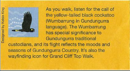
We note that on the Parks Service flyer for this new track there is a reference to an artwork image used as a ‘wayfinding icon‘ on newly installed track side sign posts along this track. This is the explanation of this “icon” on that flyer:
But Nature Trail has an issue with this image and its use by the Parks Service. It has been directly plagiarised from Nature Trail’s business logo online by the artist contracted by the Parks Service.
![]()
We have started dealing with our concerns on this issue with both the Parks Service and Blue Mountains Council, since discovering this plagiarism recently.
We also question the Parks Service brochure’s statement:
“A Blue Mountains multi day walk on Gundungurra country.”
Firstly, this contradicts the overall premise of the brochure that this “walk” takes just two days to complete. Realistically, we reckon it demands more like seven days for most casual hikers who are not in the league of cross-country marathon runners.
Secondly, this statement signals out only the Gundungurra traditional local Aboriginal custodians and ignore others such as the similarly recognised Dharug traditional local Aboriginal custodians of the Blue Mountains region. This suggests that the Parks Service has political bias and is distorting pre-historical reality.
Is there an ulterior motive such as ‘cancel culture’ entwined by this declaration?
(6) Target Market Suitability?
Having hiked these tracks along this route over the years, we raise a few other key concerns about the suitability of this newly conceived 20km track, about the route and about the dearth of hiking provisions en route.
This includes:
- Acceptable hiking pace (allowing for track grade and conditions)
- Daylight hours (with a generous buffer for contingencies)
- Guest time availability
- Public toilet facilities
- Access to drinking water
- Seating
- Safe shelter from sun, rain and lightning
- Public transport
- Access to food services
- Mobile phone network connectivity
Nature Trail focuses only on bespoke tours for single private guest group. When we select a tour design of ours, it is to suit the stated preferences of our given guests and to be within their available time window, physical capabilities, experience and gear.
With this in mind, in the case of this Grand Cliff Top Walk we are critiquing as a tour route option, we consider what the target market is. Well, on the Parks Service flyer this is the image, which supposedly represents the target market.
So, families with young children would seem to suggest the target market, not so adult hikers, trekkers, or marathon runners. Our initial reaction is that Parks Service can’t be serious, or is this a ruse? A 20 km trek over two days for such a family? No way.
To promote such is misleading, reckless and in my view exposes both the Parks Service and Council to negligence culpability.
Hikers, trekkers, and marathon runners need to be highly hiking fit, self-sufficient (drinking water, sustenance and kit), experienced in hiking. They could do this.
Let’s then consider our concerns mentioned above one at a time as each services the Parks Service (and presumably Council’s) apparent target market shown in the flyer.
Acceptable Hiking Pace?
We would suggest that a family with such young children would generally likely manage a hiking pace of about 1kph, and that is over flat ground and not allowing for regular pauses. This does not factor in the repeated climbing and descending profile particular to this track over many sections.
A maximum distance would be up to 1 km for toddlers or carrying toddlers.
Even if one could do it, the Parks Service flyer for its Grand Cliff Top Walk recommends Day One”: 11km and Day Two: 8km. At 1.5kph, the hiking duration without any pausing would be 11 hours and 8 hours respectively. No sane parent would put their children through such an army forced march bootcamp torture.
For starters, a toddler’s legs are shorter than an adult’s, and with a fraction of the muscle capacity and strength. So each step up or down for a toddler is exponentially more difficult to tackle. Further, a toddler can typically weigh up to 15kg or more according to age. Try carrying a 15kg pack on this up and down track and see how far you get!
Daylight Hours?
This track being situated in the Australian Blue Mountains, in the shortest winter months has sunrise at about 7am and sunset at about 5pm. So the daylight hours number a total of 10 hours.
Young families would not start a hike at 7am. Try more like after 10am after breakfast and normal family routine, and that’s presuming in this case the family has stayed locally the previous night. But also allow for transfers to the track start at Charles Darwin Walk, as recommended in the Parks Service flyer.
Then allow for a lunch break of at least 1 hour. Then allow for a safety margin of 2 hours before sunset to finish each day’s hike.
That’s a total hike time of 4 hours per day, and that is if the family were hyper fit.
So again, Parks Service recommended 11 hours and 8 hours respectively for Day 1 and Day 2 are ridiculously impossible for such young families as per its flyer.
Well, we could continue on, however we have realised upfront from our prior knowledge of this hiking route and the benefit of some online research, that even before venturing to undertake a recce, we conclude this newly conjured ‘Grand Cliff Top Walk’ has systemic underlying failings for its promoted purpose.
On first thoughts, we suggest tourists considering this mega track in reverse (so travelling overall slightly downhill) else we posit undertaking this is manageable staged segments, over many more multiple days or as separate trips on different occasions, thus:
SEGMENT 1: Wentworth Falls Railway Station to Conservation Hut
SEGMENT 2: Conservation Hut to Fairmont Resort
SEGMENT 3: Fairmont Resort to Gordon Falls Picnic Reserve
SEGMENT 4: Gordon Falls Picnic Reserve to Leura Cascades Picnic Reserve
SEGMENT 5: Leura Cascades Picnic Reserve to Echo Point Lookout
SEGMENT 6: Echo Point Lookout to Scenic World
SEGMENT 7: Scenic World to Katoomba Railway Station
Taking this segmented approach, we are returning to the original traditional shorter and popular tracks that comprise this new newfangled mega track desktop contrivance.
Each requires half a day or so, thus more manageable for most hikers – local and visiting.
The benefit of segmenting this track is that each segment is a manageable unit, and of course a day or two may then be taken up by a selection of a combination of segments. For the reasonably fit and average hiker, we recommend no more than two segments per day. We also recommend that if taking on two segments in one day, morning then lunch then and afternoon segment, that any more segments be tackled after a day’s break from hiking.
There is no compulsion to attempt completing the entire overall track of nearly 20km. The ‘Grand Cliff Top Walk’ is a marketing construct by government bureaucracy, few of whom have likely actually tried it, except on paper from an office desk.
In fact our suggested sequenced track segments 4,5 and 6 for ‘Grand Cliff Top Walk’, comprise the historic Prince Henry Cliff Walk, as we’ve described previously. The track length of this part (day-2) is purportedly 7.7 km according to Blue Mountains Council signage guesstimates. See example below.
Council’s on-track wayfinder sign situated at Gordon Falls Picnic Reserve for its new ‘Grand Cliff Top Walk’ jointly with the Parks Service. It displays “Scenic World 7.7km”.
But our research confirms that this historic Prince Henry Cliff Walk is more than the signposted 7.7km. Compare the 2024 sign above situated at the track start departing the Gordon Falls Picnic Reserve toward “Scenic World” (was previously called just Scenic railway). It reads:
“Approx length of the walk 9.5 km”
[SOURCE: Upper Blue Mountains Geographical Encyclopaedia, 2nd. Ed, 2001, by Brian Fox, p. 134]
But also, on foot the overall trail is further than the officially claimed “19.7 km” on the Parks Service flyer and track signage. Our basis for this presumption is firstly, that this track rises and falls considerably from flat level ground, so making the actual string measurement of the track much longer than shown on a map. The track is dominated by many stair descents and climbs.
However, it is also the original eastern starting point of the historically important Prince Henry Cliff Walk that was first constructed by Great Depression labour in 1930s. It was never intended to be a track to be completed in one day, but deliberately made accessible from multiple points along the clifftop for hikers to have a choice to join and exit each section.
As at the time of writing many sections of the Prince Henry Cliff Walk were closed to the public due to landslips. Once section immediately west of the Gordon Falls Picnic Reserve has been close for five years since the 2020 East Coast Lows meteorological events.
Other Shorter Segmenting options for the ‘Grand Cliff Top Walk’ Track
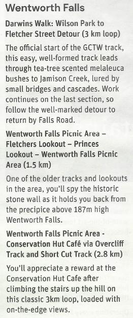
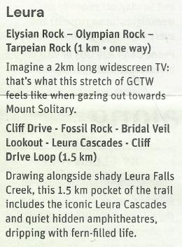
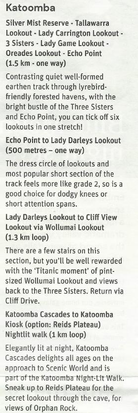
We red last winter in Blue Mountains Tourism’s freely distributed magazine that promotes tourist visitation to the Blue Mountains about this new Grand Cliff Top Walk. It was on the front cover.
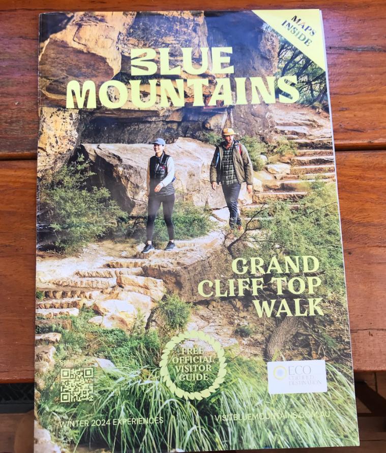
Flicking through the pages we found on pages 11 and 12 are article introducing this written by Caro Ryan, who happens to be a fellow local Blue Mountains hiking expert, whom we happenchanced met on-track on an occasion.
Caro has stated a similar approach to this 20km monster trek by instead sensibly tackling it by “shorter walks”. Caro article is very constructive and a safety-minded contribution to visitors.

Yes, agreed. This track is newly well sign-posted with ‘wayfinding’ signage at key track junctions.
In this article, timely published just a season after the track was official launched, reading between the lines, Caro has obviously hiked the length of the nigh 20 km amalgamated Grand Cliff Top Walk track. This is to her credit, as are her recommended approach for the general public. Well done!
We review this, so this is not breaching any copyright. Read on…
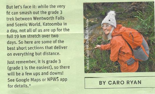
Our Comment: Parks Service claims the overall track length to be 19.7 km, so we rounded it up to 20 km. Side tracking to lookouts and toilets, plus the initial walking from the Wenty train station to Darwin’s Walk is 350 metres alone. We reckon the track deserves the 23km milestone – details later.
We agree with the suggestion of breaking this track into shorter hiking options, since this is far more manageable for most hikers. Doing so, makes it is also more flexible depending upon the hikers’ time availability, fitness level and preferences and preferred pace and breaks.
Hikers of course vary across a spectrum in these considerations in terms of ability, pace and purpose:
- Slow interpretative Nature trailing
- Nature photography
- School Group Hiking
- General Independent Hiking
- Club Paced Hiking
- Individual Exercise Jogging
- Group Marathon Running
As for the latter, Nature Trail considers Group Marathon Running an inappropriate, exploitative and damaging use and abuse of hiking tracks through ecologically prized World Heritage, and incompatible with other users (it excludes other users)
At Nature Trail, we prefer a gentler, interpretative pace and taking advantage of a selection of the best lookouts as short side trip diversions off the main track. This is because much of the main track does not offer uninterrupted wide-angle scenic vistas of the magnificent Jamison Valley. So by choosing to ritually stay on the marked track and ignore the lookout diversions, hikers will miss out on the best vistas en route.
Conversely, at the other extreme, if hikers choose to explore every lookout, they will end up mostly getting the same vista repeated. For instance, from Nature Trail’s local knowledge, we know that Bridal Veil Lookout (below) is superior and just a convenient 60 metres off on a side track, compared with General Copeland’s lookout with is 250 metres, and Fossil Rock Lookout and the view nowhere near as wide-angled.
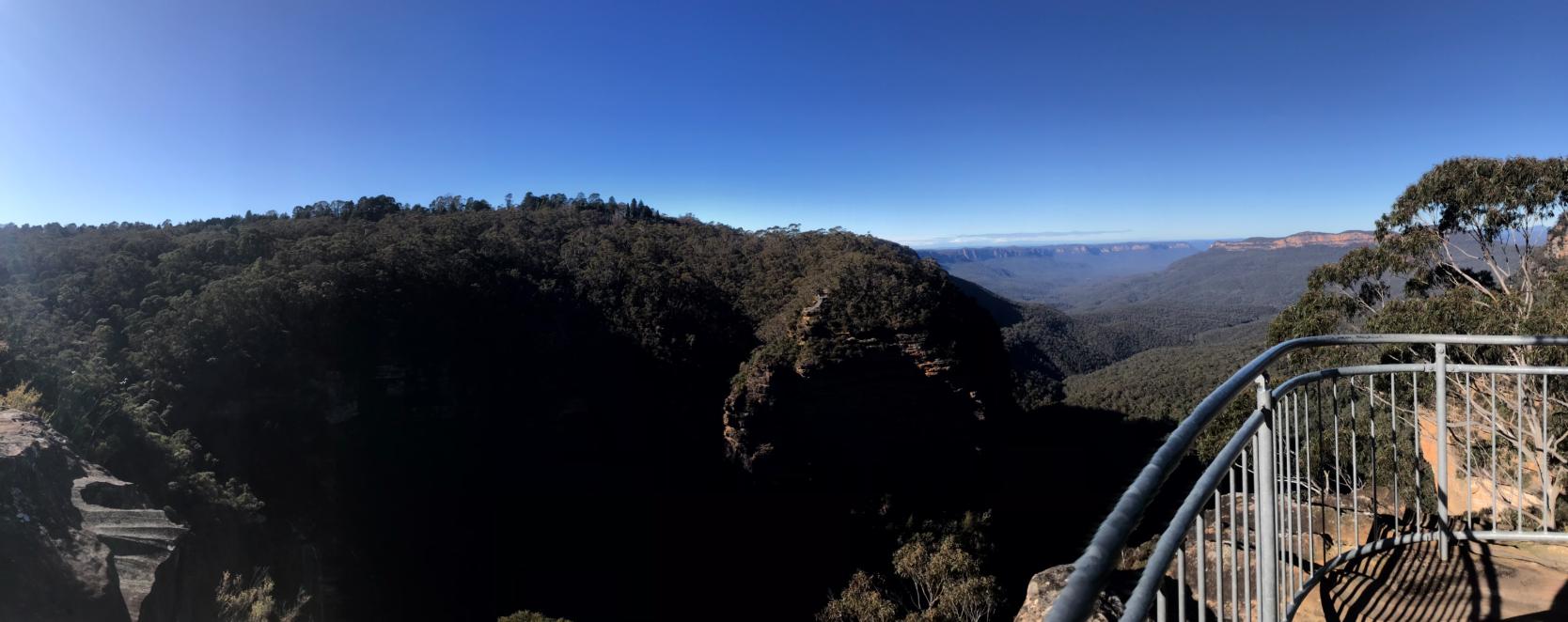
Nature Trail Lookout Rating (Bridal Veil Lookout): Vista Spectacle: 4/5 | Panorama: 180 degrees | Safety: 5/5 | Sidetrack Accessibility: 4/5 | Visitor Capacity: 10 pax | Vertigo Risk: 2/5 | NT Tour Plan Dwell: 15 minutes (max 6 guests).
As Nature Trail undertakes it’s reconnoitre (recce) of this new track, with Friends of Nature Trail, we follow the recommended hiking direction as per the Parks Service flyer, and do so by the above segments in turn, one trip at a time.
Our recces involve recording Journal Notes, taking photographs, en route discussions and a car shuffle to avoid hiking backtracking. So this means the pace is slow and duration of the recce is longer than what would be delivered to our paying guests.
This information shall be published on this website as separate articles, segment by segment in due course.
Links to detailed article on each segment of this Grand Cliff Top Walk we recommend:
(NOTE: These links are yet to have content published)
>Blue Mountains Grand Cliff Top Walk – a misleading article
>SEGMENT 1: Wentworth Falls Railway Station to Conservation Hut
>SEGMENT 2: Conservation Hut to Fairmont Resort
>SEGMENT 3: Fairmont Resort to Gordon Falls Picnic Reserve
>SEGMENT 4: Gordon Falls Picnic Reserve to Leura Cascades Picnic Reserve
>SEGMENT 5: Leura Cascades Picnic Reserve to Echo Point Lookout
>SEGMENT 6: Echo Point Lookout to Scenic World
>SEGMENT 7: Scenic World to Katoomba Railway Station
________________________________________
References & Further Reading:
[Each source below accessed: June 2025 and prior]
[1] ‘Grand Cliff Top Walk unveiled in Blue Mountains‘, 2024-03-25, Blue Mountains Gazette (newspaper), ^https://www.bluemountainsgazette.com.au/story/8566633/grand-cliff-top-walk-opens-connecting-wentworth-falls-to-katoomba/
[2] ‘Grand Cliff Top Walk – Blue Mountains‘, printed colour brochure, by National Parks and Wildlife Service of NSW (NPWS), (undated), DCCEEW, 2 pages. Also available on its website: ^https://www.nationalparks.nsw.gov.au/things-to-do/experiences/grand-cliff-top-walk
[3] ‘Grand Cliff Top Walk‘, (undated), by Blue Mountains {city} Council, ^https://www.bmcc.nsw.gov.au/grand-cliff-top-walk
[4] ‘Grand Cliff Top Walk‘, Trip Advisor, ^https://www.tripadvisor.com.au/ShowTopic-g1426078-i13268-k14748709-Grand_cliff_top_walk-Blue_Mountains_New_South_Wales.html
[5] ‘The NSW Grand Cliff Top Walk is a Tough Trail With Dreamy Blue Views‘, 2025-04-16, by Tayla Holborow, edited by Jess Barlow, We Are Explorers, Sydney, ^https://weareexplorers.co/grand-cliff-top-walk-katoomba-nsw/
[6] ‘Food lovers guide to the Grand Cliff Top Walk Blue Mountains‘, 2024-06-12, by Caro Ryan, Lotsafreshair, (an adventure hiking operator), ^https://lotsafreshair.com/food-lovers-guide-to-the-grand-cliff-top-walk-blue-mountains/
[7] ‘Gordon Falls Lookout Development for Whom?‘, 2020-05-16, article by Steven Ridd, in his capacity as Conservation Consultant, The Habitat Advocate, Katoomba, ^https://habitatadvocate.com.au/gordon-falls-lookout-development-for-whom/
[8] ‘NPWS (Parks Service) plagiarises Nature Trail’s copyright logo‘, by Steven Ridd, Nature Trail, 2025-05-30, ^https://naturetrail.com.au/blog-post/npws-parks-service-plagiarises-nature-trails-copyright-logo/
[9] ‘Great Circuit of the Jamison Valley‘, 1986, by Jim Smith Ph.D, in printed book ‘How To See The Blue Mountains‘, 2nd Ed., published by Second Back Row Press Pty Ltd, Katoomba, pp 55-59, 61-63, 108-112.
[10] ‘Prince Henry Cliff Walk‘, (feature 1082), in printed book ‘Upper Blue Mountains Geographical Encyclopaedia’, 2nd Ed, 2001, by Brian Fox, Bathurst, ISBN 0 9578737 1 9, p. 134
[11] ‘Current alerts in this area‘, (hiking track closures), Blue Mountains National Park, last reviewed: Fri 4 July 2025, 3.12pm, NPWS, ^https://www.nationalparks.nsw.gov.au/visit-a-park/parks/blue-mountains-national-park/local-alerts