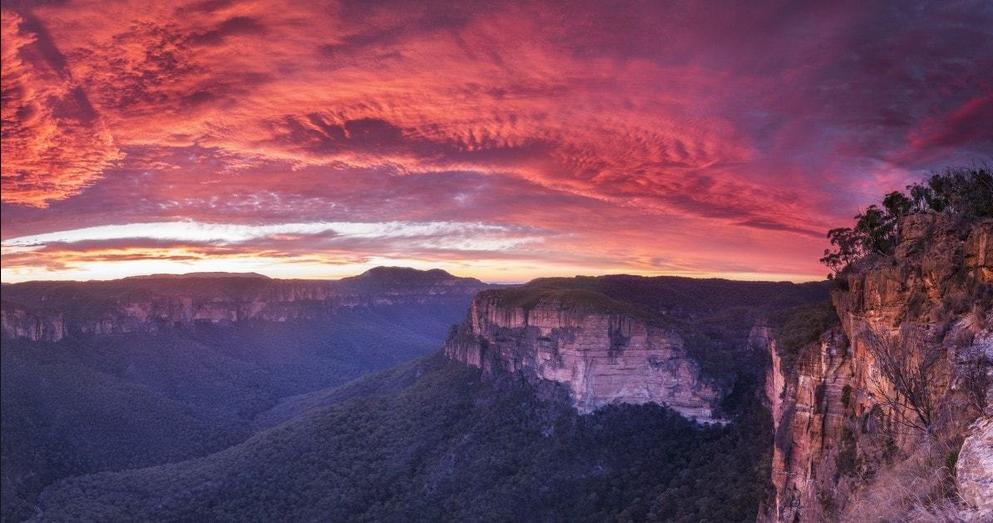
Central Blue Mountains
The Blue Mountains Region
The Blue Mountains Region is a vast naturally forested region in inland New South Wales characterised by raised plateaus, deep gorges, escarpments, mountains, upland swamps, and river valleys that contiguously span 220km north-south and 100km east-west.
Much of the is a series of dissected plateaus carved in sandstone bedrock separated by forested gorges up to nearly 800m deep. The highest point is at Mount Bindo with an elevation of 1,362 m AHD.
Geologically, The Blue Mountains is a distinct physiographic section of the larger Hunter-Hawkesbury Sunkland province. The geomorphology of the region dates 470 million years ago to the Ordovician Period of the Earth’s evolution when it was under the sea. This was followed by the Carboniferous Period when extensive forests emerged.
A movement in the earth meant that the quartzite landscape was flooded by a shallow sea from the east. Streams flowing into this sea carried huge amounts of sediment, which were deposited in horizontal layers. Later, these layers formed rock beds of shales, siltstones and mudstones. During the Triassic Period, large rivers dumped vast quantities of sand on top of the shales, burying them. Throughout this burial process, the weight of the accumulating sediments caused the layers to sink, creating a basin.
Sand collected in the basin, which continued to subside. As the deeper beds were buried, they were forged into hard metamorphic rock by heat and pressure. Above them, the first layers of sand formed the Narrabeen sandstones (about 200m thick).
About 170 m.y. ago, the sands stopped being deposited. Forces in the earth started pushing the rock strata upwards. The hard rock layers on the bottom bent and flexed, and the sandstone above them fractured into a series of vertical cracks.
Eventually, the rock layers rose into a broad plateau. Dramatic volcanic activity occurred around 150 m.y. ago forming volcanic vents which caused basalt lava to flow up through the cracks in the sandstone and shale, spread over the landscape up to 140m thick forming Mt Hay, Mt Wilson, Mt Irvine, Mt Banks and Mt Tomah, Mt Airly, Kerry Mountain, Nullo Mountain, Mount Coricudgy, Tayan Peak and others.
Subsequent erosion by rivers and weather over millions has produced deep valleys and gorges cut into the raised plateau that forms the dominant feature of the Blue Mountains landscape.
The Greater Blue Mountains Area was listed as a World Heritage Area by UNESCO on 29 November 2000 essentially on the basis of Eucalypt diversity of outstanding universal value, and outstanding diversity of habitats and plant communities that support its globally significant species and ecosystem diversity.
A large part of the Blue Mountains is incorporated into the Greater Blue Mountains Area World Heritage Site of some 10,000 square kilometres, including the Blue Mountains, Kanangra-Boyd, Wollemi, Gardens of Stone, Yengo, Nattai and Thirlmere Lakes National Parks, plus the Jenolan Caves Karst Conservation Reserve.
The Central Blue Mountains
We explore the two majestic valleys of the Blue Mountains National Park – Jamison Valley and the Grose Valley and the raised escarpmented plateaus adjoining. The custodial Parks Service terms this central region within the Greater Blue Mountains World Heritage Area, the Kedumba Sector. Much of the area is remote wilderness characterised by Eucalypt temperate old growth forest and heathland landscapes with botanical diversity and there are many historical hiking tracks throughout.
We also explore the Central Blue Mountains westward of Boddington Hill known by locals as the Upper Mountains. This takes in the villages of Wentworth Falls to Mount Victoria along the Great Western Highway. We also venture to basalt capped peaks of Mount Wilson, Mount Irvine and Mount Tomah.
- Upper Blue Mountains Escarpmented Plateau
- Villages from Wentworth Falls to Mount Victoria
- Narrow Neck Plateau
- Kings Tableland – lookouts and old growth forests
- Mount Hay Plateau – wilderness
- Mount Banks Plateau
- Mount Wilson and Mount Irvine
- Mount Tomah – botanical gardens
- Jamison Valley
- Grose Valley
- Cedar Valley
- Middle Mountains waterfalls and rainforest tracks
- The Blue Labyrinth
![]()
This webpage updated 5th January 2023.