Heat Stroke Death down Lockley Track in full summer western sun
So what fools plan to hike in Blue Mountains mid-summer in forecast high temperatures in the mid-30os Celsius (the mear shade temperature, that is) in scorching full sun?
Amateur hour ignorant fools? Or was there else perhaps something more sinister at play between the two hikers?
Tragically, one of the two teenagers died of likely heat stroke as a consequence; anyone is susceptible. Media reported that on the Thursday 29th January, emergency rescuers/searchers found the teen’s dead body in a nearby creek of their reported hiking route. The two hikers, reportedly known to each other, had set off the day after Australia Day (being 26th January – in Aussie hot mid-summer).
No less, another sad outdoors recreation tragedy has just occurred in our Blue Mountains World Heritage Area – as if that UNECO recognition means anything like custodial leadership, management and best practice visitation safety? That’d be the day!
The two hikers planned and set off regardless of conditions it seems, to hike with full backpacks for a 3-Day trek which was mostly to be atop a shadeless high altitude (~1000km AMSL) plateau roadway along a rocky unshaded and unmaintained goat track into the direction of the harsh hot western sun 40o+ Celsius, with no carried water left?
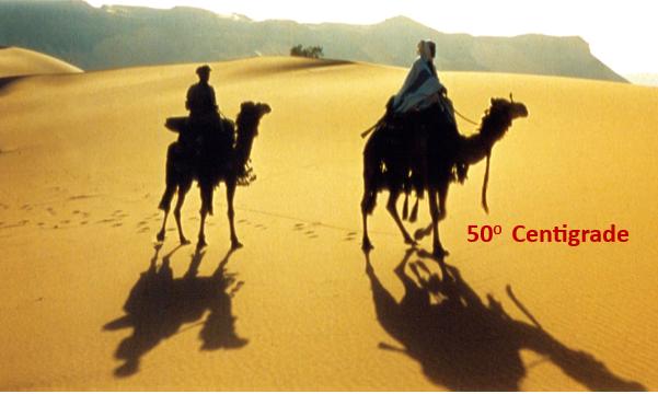
Outdoor exertion in such extreme heat, with no water is high risk and deadly. This image clearly is not of the Blue Mountains, yet real of Middle Eastern, Saharan, and indeed of Australia’s desert interior heat conditions. Such full-sun temperatures do reach 50+ centigrade, well above forecast max in-shade temps only. And these two cameleer types shown in this image are not hiking, likely local, experienced, suitably prepared, kitted up, and acclimatised, but note sitting 2m above the reflective hot ground surface and also the shadows are long, meaning…cooler.
One reflects upon such a tragedy again of late as a hiking tour operator/director locally in the same Blue Mountains. One has hiked this same track.
Two relevant experiences come to mind:
(1) 2010 in Abu Dhabi in the desert
(2) 2015 on the same track (different direction) participating as a TAFE Outdoor Recreation Diploma student on an overnight hike of 8th and 9th March 2015.
This author had such an brief experience of 50+ centigrade in Abu Dhabi, United Arab Emirates, when deciding to ‘experiment’ with a 24-hour stopover with Etihad Airways on one occasional flight from SYD-DUB at Abu Dhabi and do some brief local sightseeing.
This is a photo of this author at the time.
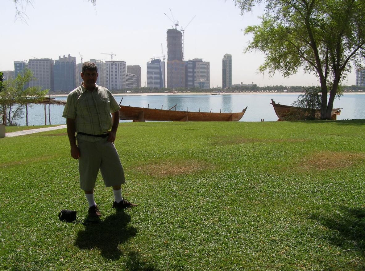
It doesn’t look like it, yet it was certified 50 centigrade in Abu Dhabi at that time. Never again! I was accompanying my wife to Ireland to catch up with her folks over there. My wife took this photo of me but then immediately told me that she was suffering from the heat severely and couldn’t cope. So I instantly ended this stop, got her and me back into an air-conditioned taxi (cooling on max cold and full blast) and were safely driven back to out stay in such outside extreme conditions. But never again will I take that risk! I was 46, so I ought to have known better.
Could have and should have young Andre’s death out trekking have been avoided? We suggest so. Can others learn wisdom from this? We suggest so – please read on.
This was their route:
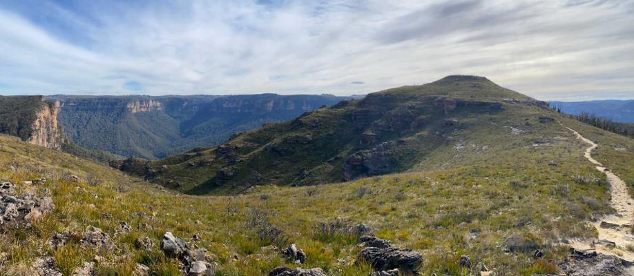
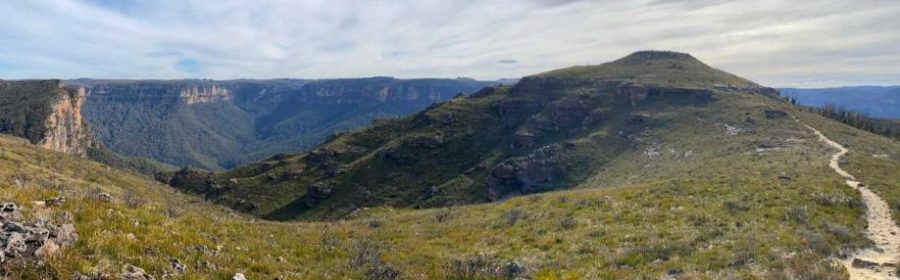
‘Lockley Track’ toward ‘Lockley Pylon’ (928m AMSL) a small grassy (and ancient basalt-capped symmetrical volcanic hill shown on the horizon on the right). This photo (on a shady day – mind you!) faces northward (NW) from this narrow hiking track near Mount Stead atop Mount Hay Range (plateau). The track is exposed to extreme sun and heat especially in the summer months (Dec-Feb). There is no shade. The track is akin to a goat track and is unmaintained. LOCAL WARNING: This is wild remote country, yet situated accessible to Leura Railway Station within a few hours road walk.

Andre Márquez (a visiting Filipino lad?/not a Blue Mountains trekking local?). We just don’t know as yet. He has been identified on the Internet as the 16-year-old boy who died on a hiking trip in the Blue Mountains last week. He is clearly much younger in this supplied photo to the media – perhaps 13? [Picture Source: GoFundMe, https://www.gofundme.com/f/in-loving-memory-of-andre-marquez]
His cause of death?
At the time of writing, we don’t yet know. We’re not holding out in the dark for further media (that have probably moved on to other topics) nor are we holding out for any coroner’s report made public that typically never comes.
This article meanwhile reviews and analyses yet another visitation death in the ‘great outdoors’ of our beautiful, majestic, yet wild Blue Mountains region in Australia. We here at Nature Trail consider any death from outdoors activities in the Blue Mountains, where we choose to live and operate, to be tragic, unacceptable and an unnecessary avoidable waste of human life.
We recommend this book as an insightful, knowledgeable and constructive read. It was published in 2023, so before Andre’s sad demise.
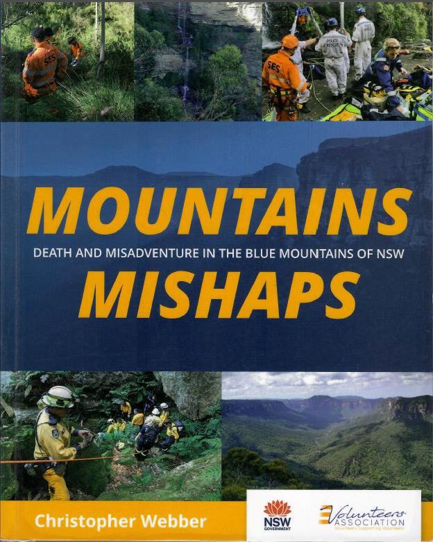
“Mountains Mishaps” (is a local documentary book by Christopher Webber)… “tells the story of search and rescue operations, the rescuers, the people who are rescued, and other incidents, in the Greater Blue Mountains World Heritage Area. Readers will not only enjoy some terrific stories, but also learn how to enjoy their trip in the Blue Mountains without embarrassment, injury or death.” The books Introduction provides insightful and pragmatic guidance for hiker safety. https://mountainsmishaps.com.au/
Yet, we really doubt whether the Blue Mountains National Park NSW Government’s custodian NPWS has any care factor for such? Such visitation deaths from outdoor activities like hiking and trekking repeatedly occur. The NPWS giftshop at Blackheath refuses to stock Christopher Webber’s book, claim it is not “family friendly”.
We herein this article seek to analyse this incidence because no-one else is nor reports the circumstances. Our purpose for doing so is to explain causation(s) and seek to educate others in an attempt to help prevent further repeats.
In this case, media reports indicate that extreme heat and dehydration were two causal factors. Such can quickly escalate to deadly heat exhaustion and then to heat stroke which probably became the cause of death of the 16 year old, but we still don’t know.
Yet there is no public reporting of such, so again no-one else learns from deaths in the mountains whilst undertaking activities like hiking in our great outdoors. The coroner rarely releases such information, except in the case of a criminal inquest – and then only sometimes.
What really is the public benefit then of a coroner? It is a head of some secret society.
Like, since the poor boy’s body gets medically examined away from the creek scene in an autopsy by a forensic pathologist to determine and report a testimony on cause of death – in this case likely drowning (since body found in creek) and so heart attack, (frankly the ultimate cause of all deaths).
But do we really get to know the causations of another local hiking death? We wish this to change this secrecy for privacy mentality (with the family’s blessing). They cannot bring back their beautiful boy, but many in such grief just resign as a minimum outcome that they wish such a tragedy can be averted to others, especially to children/teens.
From hiking experience and knowledge, we posit other contributory factors as well.
Here are a few:
- The two hikers’ skill-sets, hiking experience and local knowledge of the two teen hikers?
- The name of the 17 year old hiker is not know. Why? Does he perhaps have something to hide?
- The hiking route chosen?
- The trek planning and kit (or lack thereof) taken in?
- The actual weather was extremely hot and sun-exposed at altitude (mid-summer)
- The two hikers separated – Why? A dispute? Underlying interpersonal issues before the trip?
- Other contributory factors unknown?
The NSW Parks Service continues to bureaucratically encourage amateurs to do their own thing, with no responsibility or accountability for any visitation.
Yet the NPWS steadfastly makes it harder and unaffordable for commercial tour professionals to operate. Yet we only seek to follow best practise safety at Nature Trail – trained up, experienced, knowledgeable and so wisened to the risks, particularly that of such hiking route options and associated weather risks.
Yet, if legitimate, where is the photo of his older 17-year-old hiker buddy? Why is that buddy silent and hiding from the public media? Is there something going on here that his photo and identity is not also disclosed? Else why? Do we smell an interpersonal conflict that might have occurred out there?
What’s the bet the NSW Coroner just declares Andre’s death by the invariable and ignorant “misadventure” excuse or “accidental drowning“? Rubbish! Then a bloody useless non-investigation!
Do any of them in Sydney’s Coroners Court travel to death/crime scenes, like in this case to Govetts Creek down in the Grose Valley where Andre’s body was found? Have any NSW Coroners any local knowledge or hiking experience or seek such expert knowledge as witness accounts as part of the Coroners Report’ findings? Why do coronial findings reports or inquest reports not get published?
Why are NSW Coroners typically female? Is there some culturally gender bias?
At the time of writing, Her Honour Magistrate Teresa O’Sullivan is the NSW State Coroner and the Office of the State Coroner is located at 1A Main Avenue, Lidcombe NSW 2141.
The following Magistrates are Deputy State Coroners:
- Derek Lee – Lidcombe Coroners Court
- Harriet Grahame – Lidcombe Coroners Court
- Joan Baptie – Lidcombe Coroners Court
- Carmel Forbes – Lidcombe Coroners Court
- Rebecca Hosking – Lidcombe Coroners Court
- David O’Neil – Lidcombe Coroners Court
- Kasey Pearce – Lidcombe Coroners Court

NSW Coroner 2026, Magistrate Teresa O’Sullivan

NSW Deputy Coroner, Harriet Grahame
We note media criticism of the NSW Coroners Court. Please refer to our link to such external articles at the end of this article under the heading ‘Further Reading and References‘.
What is Heat Stroke?
Heat stroke is a life-threatening, emergency condition caused by a combination of high environmental temperatures, intense physical exertion, and dehydration. It occurs when the body’s ‘thermo-regulation’ system fails and its core temperature (normally 37°C) rises above 40°C (104°F).
Primary Causes During Hiking:
High Temperatures & Humidity: Exposure to extreme heat in direct sun, especially with high humidity, means that sweat evaporated to try to cool the body. When water intake (and hydrolytes) runs out so does the sweating.
Physical Exertion: Intense, prolonged activity (like hiking uphill with a heavy pack) generates high levels of internal metabolic heat that can overwhelm the body’s cooling mechanisms.
Dehydration: Inadequate fluid intake reduces the body’s ability to produce sweat, leading to rapid, dangerous, and sometimes fatal, increases in body temperature.
Contributing Factors:
Lack of Acclimatization: Hiking in high heat before your body has adjusted to the temperature (usually takes several weeks).
Inappropriate Clothing: Wearing heavy, tight, or non-breathable clothing that traps body heat. (Plus carrying a heavy backpack???)
Environmental Factors: Direct, prolonged sun exposure at altitude, with little or no breeze.
Alcohol/Medication: Consumption of alcohol or certain medications (like antihistamines or diuretics) that affect hydration and body temperature regulation.
Symptoms of Heat Stroke on the Trail:
Cognitive Issues: Confusion, disorientation, agitation, slurred speech, or delirium.
Skin Changes: Skin may be hot and dry, though it can still be sweaty in cases of exertional heat stroke.
Physical Distress: Rapid, strong pulse, fast/shallow breathing, nausea, and vomiting.
Loss of Consciousness: Fainting or collapse (…into a creek?)
Preventive Measures for Hikers:
Hydrate Properly: Drink plenty of fluids before, during, and after a hike, including electrolytes (sodium, potassium, magnesium) to maintain balance.

Available from ‘Snowys Outdoors’, https://www.snowys.com.au/
“Hydration during a game, tournament or workout ― not just before and after ― can fall below the radar of an athlete and their trainer, but performance depends on it. Getting dehydrated puts you at risk of headaches, cramping and more serious complications like heat stroke or other heat disease.”
Time Your Hike: Avoid hiking during the hottest part of the day (e.g., hike early morning or late afternoon).
Take Breaks: Rest frequently in the shade.
Dress Appropriately: Wear loose, lightweight, light-colored, and breathable clothing.
Know Your Limits: Turn around if you experience symptoms like headache, dizziness, or lightheadedness. (Or just find a shady place, sit down and dial emergency 000).
If you suspect someone has heat stroke, seek medical help immediately (call emergency services), as it is a medical emergency. Move them to a cool/shaded area, remove excess clothing, and try to cool them down with water, cold wet cloths, or ice pack.
The hikers’ chosen trekking route?
The media reported on Friday 30th January 2026 that two teenage lads apparently from the nearby Sydney’s outer suburb of Emu Plains (adjacent at the eastern base of the Blue Mountains World Heritage Area) were involved and had planned a 3-day backpack camping trek traversing the Grose Valley.
The dates concern were Tue 27, Wed 28, Thu 29 January 2026. They travelled by train from Emu Plains Railway Station to the Blue Mountains Leura Railway Station.
The media report that they planned to then hike from Leura Railway Station to camp at Mount Hay (Day 1), thence down the escarpment descending into the Grose Valley and camping at established and well known Acacia Flat remote camp site (end of Day 2), thence (on Day 3) to complete their hike climb out of the Grose Valley. Presumably the trekking route out was to be westerly up to Blackheath township outskirts and then walk to Blackheath Railway Station before training back home to their starting location at Emu Plains Railway Station.
This is our uninformed presumption. We say presumption because we don’t know the facts. So these present so-called ‘known unknowns‘ (by us), perhaps else the planned trek only communicated to their close friends and or family, or may be not at all. Again, who knows?
Tragically, the two didn’t make it to their trek’s intended Day 3.
Their chosen trekking route has not been reported at this time of writing and so is not known to us. Their route is still not yet reported publicly. A key question is why not? Can others not therefore learn wisdom from another such outdoors tragedy so as to prevent a recurrence, yet again? Hello!
[AUTHOR’S NOTE: Nature Trail defines a ‘hike‘ as being up to one day in duration, whilst a ‘trek‘ entails a duration of more than one day that necessitates backpack camping (not car camping). This enables us to be very clear in communication of what our guests can expect and so prepare for. Clarity in the great outdoors and activities in remote areas are vital for health and safety. Every participant deserves such and to return safely, well and injury free; not just to have ‘fun’].
So without such insight, we can only surmise from the scant media reports that the main hiking route options were taken; but from what source of ‘guidance’? From where did the two obtain their route source information? Likely online, but likely such online guidance was not officially certified as safe, rather as being some “adventure”, so appealing to teenage boys.
The custodial authority for the Blue Mountains National Park is the National Parks and Wildlife Service (NPWS). Yet, it still does not have a website with certified hiking and trekking routes that visitors can use and rely upon. It responsibly should and in 2026 (at the time of writing) such should be available outside mobile phone range en route anywhere throughout the Greater Blue Mountains World Heritage Area.
The parents ought to know this.
The chosen route taken is no less a challenging one overall, irrespective of which route options were taken and intended to complete the twos 3-day trek. To remote trek between the two railway stations (Leura and Blackheath) via Acacia Flat and presumably backtracking up via the Horse Track is roughly an estimated 30km, noting that that the quicker Rodriguez Pass track option continues to remain closed due to multiple landslips (after many years mind you).
[AUTHOR’S NOTE: We don’t know where the quoted “45km” trekked distance hiked comes from as reported in the media by local hikers helping out at the time. We can only surmise that the extra 15km (form our estimated 30km) was that the two hikers had in fact diverted Day 1 away from Lockley Track and indeed had ‘adventure’ camped away on Mount Hay itself (as a mission achievement perhaps?). That northerly track diversion is a separate ~7km hike each way between the track junction at The Pinnacles feature on Mount Hay Road. may be they anticipated a majestic view from the top of Mount Hay. No, having been there there are glimpse through tall trees. The trees grow well because Mount Hay is capped in rich volcanic soil, and rocks].
Alternatively, the two hikers could have planned to slightly backtrack after then camping Day 2 at Acacia Flat, on Day 3 northward through Blue Gum Forest then diverting NW up Perrys Lookdown track climb out the Grose Valley track and through into Blackheath. That is if they had properly researched their route options, and knew how to do so.
However, the road walking for some distance is seriously boring, not pedestrian safe due to vehicular traffic (and no footpaths) and not recommended.
Else alternatively, they could have returned the way they came (but such is not a normal choice for hikers – as perceived as a similarly boring repeat of sameness, especially in this case knowing the climb down is pretty marginal, let alone a return back up it!).
There is also another alternative hiking route option out but it is not well known, is very dangerous (cliff exposure, high grass snake risk, not maintained, and so not recommended. It is also nowhere near public transport, which presumably the two boys were dependent upon to return home on Day 3.
That hiking route as an emergency option is to hike from Acacia Flat south along Rodriguez Pass then just before Grand Canyon at a hiking track junction (left) right below the high electricity transmission line way above is to take a small (difficult to find) windy track diversion southward to the Grand Canyon Road and thence walk westward to Medlow Bath Railway Station, but it’s about a 5km hike/walk climb up and out of the Grand Canyon.
Our presumptive guesses of the two’s presumptive trip plan:
Day 1: Emu Plains (by train) to Leura Railway Station > Hike along Mount Hay Road > Mount Hay (presumably to bush camp)
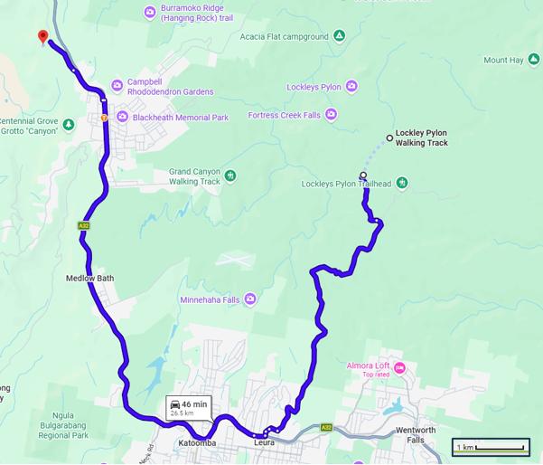
The aerial photo below shows the route from Leura Railways Station at bottom east along the Great Western Highway then northward (NNE) along Mount Hay Road to the entry point of the Blue Mountains National Park.
Here, without reported information to the contrary, the route is direct. Again it is presumed that the two hikers carried in self-sufficient supplies (water, food, kit) and did not divert to shop for anything in Leura village after arriving by train at Leura Railway Station.
It is about a 4.5km walk; not a track hike as such. The section shown below for the most part is a bitumen road through initially a residential area from the highway that then peters off into scattered rural properties and into the National Park. The road travels along the 1km high plateau top and typically is exposed to direct hot sun, high temperatures throughout, including extreme ultraviolet radiation rated at 11+ during the summer season in Australia (December-February). This can become cancerous.
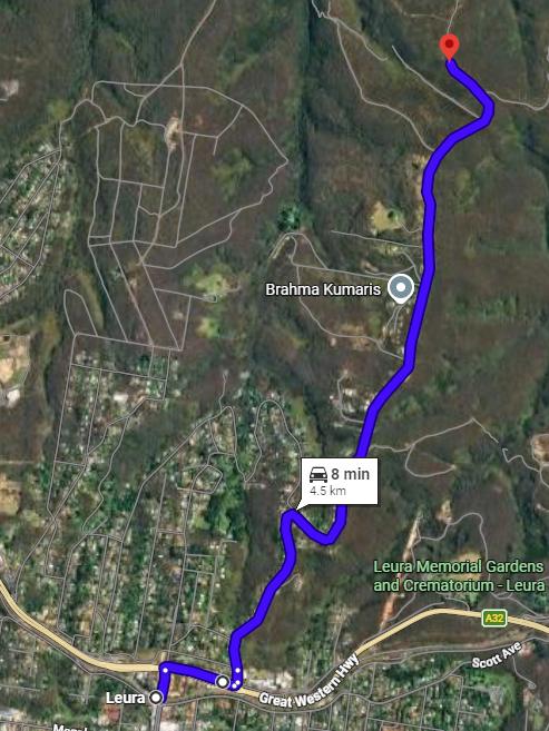
ROUTE LEG 1: (presumed) Aerial Photo Map of the southern section of Mount Hay Road, Leura (north) including between Leura Railway Station and the entrance of the Blue Mountains National Park. Note the indicated 8 minutes is by car, but that would be speeding. [Source: Google Maps]
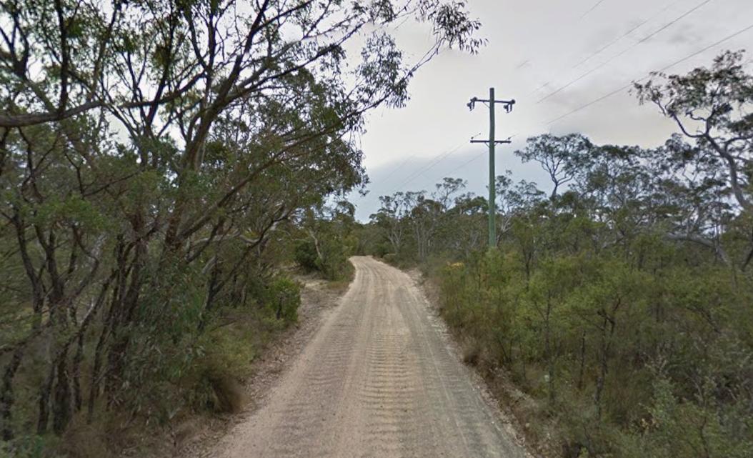
Mount Hay Road once past the ‘Brahma Kumaris‘ (being a spiritual meditation retreat) as indicated on the aerial photo map above, the northern narrow section road surface into the National Park deteriorates from being bitumen to a road-base (a sandy gravel surface as shown above). Hey, this photo is on a cool cloudy day, so don’t be hoodwinked of the mid-summer heat extremes making this full-summer to be extreme desert trekking! We don’t recommend doing such.
The Google Maps locator pin (red inverted tear drop-shaped icon), shown on the above map, marks the map location of the National Park entry point at a lockable road gate. The location is approximately 500m north of the high voltage electrical transmission lines crossing up high overhead the road, along the road.
The electrical transmission lines overhead of Mount Hay Road about 500m south of the Blue Mountains National Park road entrance gate. This is an unmissable reference point (in daylight).
The Grid Reference co-ordinates of the Blue Mountains National Park entrance gate along Mount Hay Road are Latitude 33°41’00.1″S, Longitude 150°20’48.9″E. Grid Referencing is useful software navigation feature offered by Google Maps. See below.
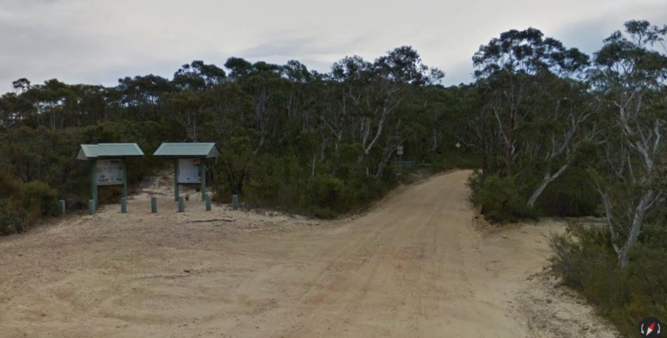
The location of the Blue Mountains National Park entrance looking northward along Mount Hay Road, Leura [33°41’00.1″S, 150°20’48.9″E]. Note the two NPWS tourist information signs on the left of this photo. The NPWS lockable road gate is just 50m further up the dirt road (out of sight in this street view toward the right of this photo). The gate is often times locked yet unannounced such by NPWS, so making this access route a tad Russian Roulette unreliable (unless one wants to use say an angle grinder on the lock – but so doing such is illegal, so be warned.)
We estimate that the walking duration between Leura Railway Station and the Blue Mountains National Park entrance (we term ‘Leg 1‘) would be in the range of 1.5 to 2 hours; allowing for the hikers’ unfamiliarity with this chosen route, so pausing for map navigational checking, road traffic allowances and the hot temperature.
Did the two hikers divert to Mount Hay of their trek Day 1 to bush camp overnight? This is not known.
Mount Hay is not exactly en route between Leura Station and Acacia Flat, but rather a significant 7km diversion NW from the Grose Valley traverse route (each way!). Is this what hiking adventure entails? No plans and just going ‘woop woop’ to a hilltop for fun?
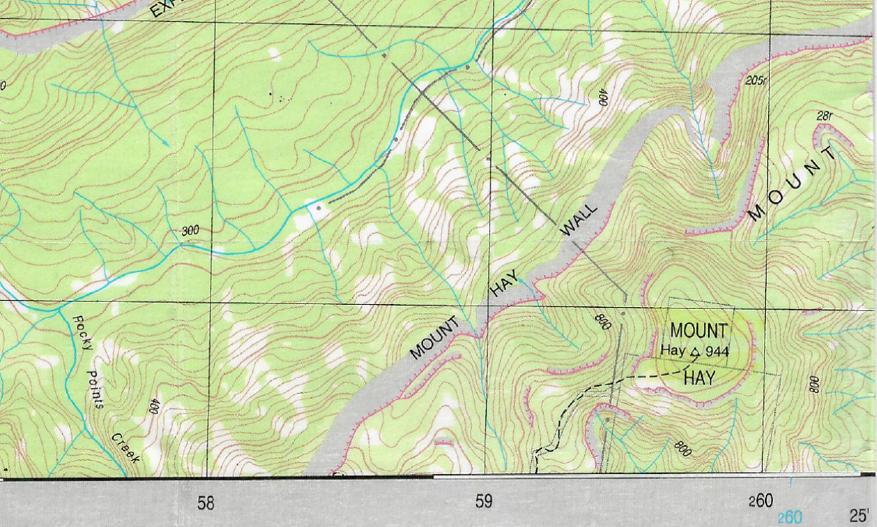
We have sourced the two relevant connected topographical map extracts of this Day 1 route, with labels below – note the aligned longitudinal reference lines that we have gone to the trouble to reproduce for explanative clarity.
On the adjoining topographical maps below, the star icon represents the track junction of Mount Hay Road and Lockley Track near and just south of ‘The Pinnacles‘ geographic feature. Route Leg 2: (Day 1) the arrow indicator shows the divergent route from The Pinnacles to Mount Hay itself – (arrow indicator ‘B‘) not exactly en route to the Grose Valley. Route Leg 3 (Day 2): the presumed outbound trek route, so backtracking ‘B‘ back to ‘The Pinnacles‘, thence (arrow indicator ‘A‘) along Lockley Track then down into the Grose Valley to Acacia Flat (camping ground) (off map).
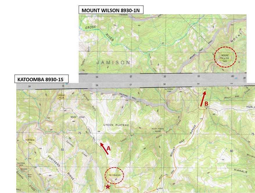
These two connecting topographic maps are relevant here. The standard topographical map is 1:25000 scale, so that each map square of 4cm x 4cm represents 1km x 1km on the ground. [NOTE: If you are looking at this article from a mobile phone and not a PC, then good luck with your eyesight!]
It is a hiking navigable scale. Yet are such topographic maps in print form available anymore. Does NPWS possess and sell these maps any more, say at its Blue Mountains Heritage Centre situated at 270 Govetts Leap Rd, Blackheath near Govetts Leap Lookout? Does NPWS even bother or care about providing hiking navigation information and such vital tools to visiting hikers/trekkers to the Blue Mountains World Heritage Area?
This is an aerial photo (shown in purple) on Google Maps between the Blue Mountains National Park entrance and Mount Hay summit:
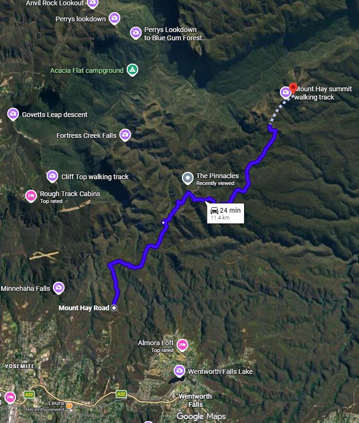
ROUTE LEG 2: (presumed): Trekked route from bottom to top of this aerial photo – being along Mount Hay Road from Blue Mountains National Park entrance at location Latitude 33°41’00.1″S, Longitude 150°20’48.9″E to Mount Hay. Note the location of Acacia Flat campground (shown in green) being along a different hiking route NW of the track junction near The Pinnacles. [Source: Google Maps]
‘The Pinnacles’ geographic feature (landmark) is a unique distinctive highly visible rock outcrop atop the Mount Hay Range. It is useful for navigational triangulation (one of two vectors required) observable from a distance. See close up photo below.
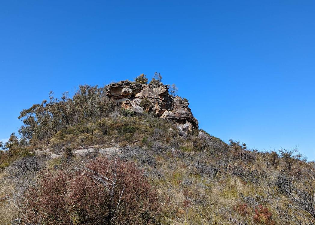
‘The Pinnacles‘ – a distinctive highly visible rock outcrop atop the Mount Hay Range. The location shown on the aerial photo above. It is a distinctive exposed ironstone rock outcrop landmark, situated 30m east of the Lockley Track (southern end track-head). In summer extreme temperatures reach in the high 40s in full midday sun, plus the rocky ground cops and reflects and compounds the ambient extreme heat. It is a deadly location under such conditions if not experienced, prepared, equipped and frankly if not sensible. This geographic/geological feature is also shown on the KATOOMBA-8930-1S 1:25000 topographical map at MGA Grid Ref. 737565 [Latitude -33.64415293319304, Longitude 150.37253105517087].
Mount Hay (Day 1 bush camp?)
This remote bush site was reported in the media as the two hiker’s intended Day 1 bush-camp location. Yet, it has not yet been confirmed whether this site was actually camped by the two hikers, or whether another more convenient bush-camp site more en route was chosen.
From this author’s local hiking experience, from Mount Hay Road car park (~2km) to the south (off this map), there is then a narrow unmaintained hiking track up to Mount Hay summit. But there are no camping facilities or camping ground on Mount Hay nor in the area. No night lighting, or mobile phone reception, no source of water. It is just a remote hilltop (Basalt Cap) at the end of an unmaintained remote hiking (goat) track. But going ‘remote’ can be what hiking adventurers often prefer. One needs to be self-reliant/self-sufficient.
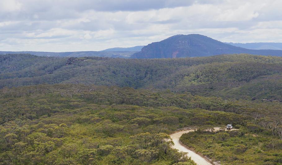
Horizontal aerial view to Mount Hay (in the background) from over Mount Hay Road looking northward. Mount Hay is covered in mature trees so provides shade atop the flat summit. Mount Hay (944m AMSL) is likely at least ten times the size of Lockley Pylon).
We do question this Day 1 camp site reporting by the media, because Mount Hay is well off route between the two hikers’ starting point at Leura Railway Station and their planned Day 2 bush camp site at Acacia Flat. It is of a prominent size seen from afar to be a luring beckoning destination.
See previous aerial map above showing the divergent hiking distance between the two camp sites of remote Mount Hay (Day 1) and the then intended Acacia Flat camping ground (Day 2). Frankly, it doesn’t make sense for them taking such a considerable diversion off their planned trek route.
Day 2: Mount Hay > hike to Acacia Flat (to bush camp)
Their presumed hiking route and waypoints:
- Mount Hay – depart bush camp Day 1 (presumably)
- Hike back south along Mount Hay Road
- ‘The Pinnacles’ track/road junction at a nearby natural rock outcrop geographic reference feature
- Lockley Track
- Mount Stead– not an obvious rise. The naming is a misnomer, so best using dead reckoning and trisection navigation position verification check
- Lockley Pylon
- Du Faur Head
- Du Faur Buttress
- Govetts Creek crossing – a shallow rocky ford crossing (in summer usually approx. 500mm deep) depending on rainfall
- Blue Gum Forest
- Acacia Flat (camping ground) – arrive at bushcamp Day 2
These two extracts connecting topographical maps with our route arrows show the presumed hiking route for Day 2 (align the grid eastings). We use the standard 1:25000 topographical maps here (rather than Google Maps) since this is a hiking route, not a car road route.
We have superimposed on these map extracts our presumed arrowed route of the two’s Day 2 hiking from Mount Hay (presumably) to their notified Day 2 campsite at Acacia Flat camping ground. The route crosses over two adjoining topographical maps, but whether they had carried such maps with them is unknown.
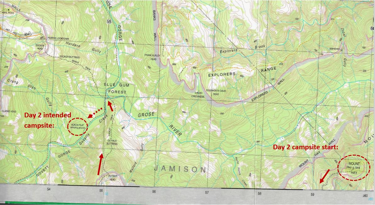
ROUTE LEG 2: (presumed): The media reports are that at end of Day 1 the two backpacked remote bush-camped on Mount Hay (circled left of map), or at least that had been the intent, but as yet unconfirmed. Then Day #2 they reportedly hiked toward Acacia Flat camping ground.
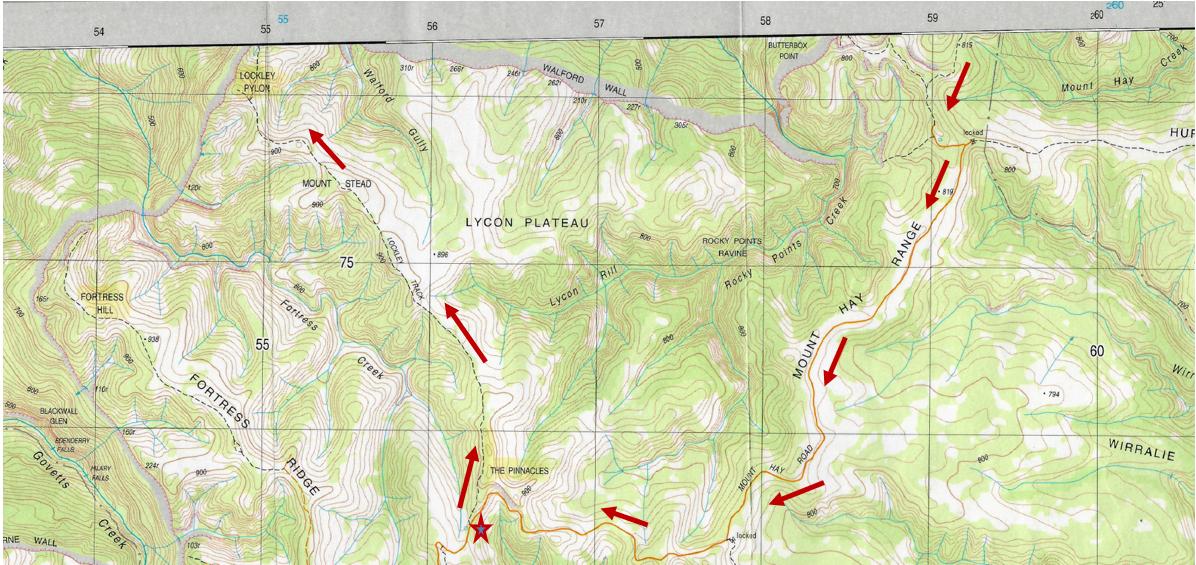
Day #2 would have required backtracking to the track junction at The Pinnacles, then resuming the hike along the Lockley Track around Lockley Pylon (shown) and then descending down the steep rocky escarpment (Du Faur Head and Du Faur Buttress) to then cross over Govetts Creek at the Grose Valley floor and then turn southward along a hiking track to camp at Acacia Flat. That was their reported intention. (See arrows on connecting both maps above).
However, these two hikers never made it to Acacia Flat on their planned trek (as per the media reporting).
The older of the two ended up contacting emergency rescue when somehow his buddy disappeared Day 2 in extreme heat and his supposed search failed to find his trekking mate, Andre. Then the older of the two (unnamed) triggered his emergency PLB device and was eventually winched by rescue helicopter from Acacia Flat camping ground to safety that evening (Wednesday 28th January 2026).
Day 3: Acacia Flat > hike to Blackheath Railway Station (via Horse Track?), then train back to Emu Plains where they reportedly started the trip from.
Yet, thereafter their planned Day 3 didn’t happen due to the two hikers separating for some reason on Day 2. This reportedly took place before arriving at Acacia Flat to bush camp together the night of day 2.
The Day 2 was walked in full sun throughout particularly in direct extreme heat, and then the reported tragic death of the younger 16-year old later “found in a creek near Acacia Flat” – presumably the adjacent Govetts Creek).
The media reporting of that separation of the two hikers on Day 2 has not been explained.
This raises questions as to why? What had transpired that Day 2 between the two of them, had there been underlying conflict? We don’t know.
Day 3 of the intended trek didn’t eventuate. The two’s intended exit route out of the Grose Valley remains also unknown.
So these accounts have what has been reported in the media.
The older boy and police would of course know more, yet such has not been disclosed publicly. There are many options, but who knows?
The Weather Conditions?
And all this would be made worse in extreme heat conditions.
We herein post an extract copy of the nearby Mount Boyce (Bureau of Meteorology – ‘BOM’) weather records for the hiking days concerned, and note those of specially their trip dates being 27th, 28th, 29th January 2026:
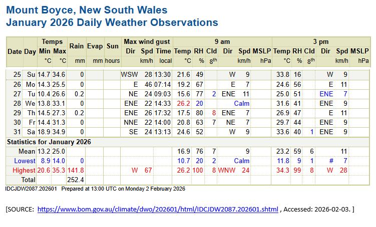
Check the dates of 27th – 29th January above. In hindsight it was relatively very hot at the time and with variable high humidity. So, 33o Celsius in the shade can escalate to the mid-40s Celsius under such full mid-afternoon sun in severe unshaded heat.
For those unfamiliar, the geographical distance juxtaposed between Lockley Pylon and (being a key hiking route location of the two boys hiking route) and the nearest weather station at BOM Mount Boyce is thus:
As the crow flies: about 10km between Mount Boyce (left) and Lockley Pylon (right)? So the same weather comparable?
So, Extreme Heat Exposure?
The two alighted a train at Leura Railway Station and then presumably walked from there directly to Mount Hay Road. Then they road-walked northward along Mount Hay Road for some kilometers. To camp where Day 1 is not known.
Yes, full sun exposure was likely around 40o Celsius from trekking from Day 2 in full sun down the northern spur of Du Faur Head and Du Faur Buttress. The spur is rocky and shadeless and the track rough and unmaintained by the Parks Service responsible.
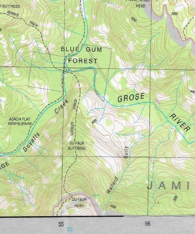
Extract of topographic map MOUNT WILSON 8930-1N specifically showing the Lockley Track section down the steep spur between Du Faur Head and Blue Gum Forest. Acacia Flat is shown.
High humidity naturally also induces increased sweating, so a loss of hydration. Sweat is our body’s natural way of cooling itself to cope with maintaining a healthy body temperature in hot environmental conditions.
Nature Trail is well familiar with the Lockley Pylon hiking track from Mount Hay Road down into the Grose Valley (or climbing out vice versa) via the hiking features of Flat Top, The Pinnacles, Lockley Pylon, Du Faur Head, and Du Faur Buttress down to Blue Gum Forest.
There is no shade to speak of, so when the ambient temperature is 33o Celsius, but that is in the shade. Yet, actually this temperature is misleading to those hiking in full sun. This particular western aspect descent of Lockley Track over Du Faur Head is over exposed rocky ground which reflects and accentuates the sun heat, meaning that the likely hiking temperature would have been 45o + Celsius or more for these two hikers.
That is unsafe.
Add Extreme UV Radiation
Yes, also at the altitude of 1000 metres, extreme UV radiation most likely was at 11+. This is potentially skin cancerous if without appropriate sunscreen protection.
The reported high humidity at 77% would have caused sweating and loss of hydration; so more consumption of carried in drinking water. Salt tablets to replenish the body salts to avoid muscular cramp?
Such is a serious medical condition.
Drinking Water?
How many litres of water did the two hikers carry in? It has not been reported. What may be 1 litre each as the typical hiking water bottle provides? Did they know the lack of water risk once hiking from Leura Railway Station along Mount Hay Road northward up and expose on the high plateau?
But water alone is not sufficient in extreme heat conditions. Body salts are also important to maintain a balanced hydration and avoid muscle cramping. But did the two hikers know that? Did they carry such body salt supplements?
“Sweating during exercise is a natural mechanism to regulate body temperature, but it causes the loss of water and essential electrolytes, primarily sodium and chloride, along with smaller amounts of potassium, magnesium, and calcium. While the body primarily loses water, significant salt loss can occur, particularly during high-intensity or prolonged exercise (lasting over an hour) in hot conditions.” [Source: Google AI]
We know from experience that there is no reliable drinking water source between Mount Hay Road and Acacia Flat (save initially resident tap water on Mount Hay Road), but once inside the Blue Mountains National Park there is no water source anywhere until down at Govetts Creek besides Acacia Flat. That water requires boiling first to be safe to drink.
So the two hikers had no water source (besides that which they carried in – how much we just don’t know but likely not sufficient; nor whether they had/took any salts or electrolytes as supplements to mitigate exercise heat stress along the Day 1 and Day 2 route atop Mount Hay Range, Fortress Ridge, Lycon Plateau or at Mount Hay in full sun.
En route there might be water at Henson Glen on the headwaters of Govetts Creek, but its off track and a bushbash and one would need the right topographical map or reliable GPS or detailed local knowledge of that location. Basically one would need to be a local hiking expert with intricate knowledge. Other nearby tiny watercourse headwaters en route are unreliable especially in summer, and Katoomba Creek flows down from toxic Katoomba Tip so avoid that like the plague!
It is still not known if the two hikers went to Mount Hay itself or where they camped Day 1. Mount Hay is well off the route to Acacia Flat. From the track head of Lockley Track at The Pinnacles off Mount Hay Road, to hike to Mount Hay itself is about 6km NE in another direction. So it is unclear whether the two hikers actually extended their route to Mount Hay. It is also not known where they camped Day 1 or Day 2.
Did they actually divert to Mount Hay as the media reported?
Is this trek a tragic repeat of 2007 David Iredale’s dehydration tragedy near Mount Solitary? [Reference: https://www.abc.net.au/news/2009-04-17/bushwalker-death-000-staff-went-unpunished/1653024]
So in this case, what happened?
Media Reports:
Well, we can only garner from what the media from various sources reported online, as follows.
According to the media, (NSW) Police say he (Andre) and his 17-year-old friend travelled to Leura train station on Day 1 (the Tuesday) before walking to Mount Hay to camp. Whether they actually hiked to Mount Hay itself and where they camped Day 1 is not known. Mount Hay is a 7km divergence situated well north-east further up on Lycon Plateau away from the Lockley Track junction of The Pinnacles geographic feature that leads down into the Grose Valley.
On Day 2 (Wednesday afternoon sometime unknown), the two walkers became separated.
As the pair approached Acacia Flat campground, northeast of the town of Blackheath, Andre vanished. Why is unexplained.
The 17-year-old say he tried to immediately search for Andre for up to 4 hours.
In the process he happened by other hikers camping at Acacia Flat.
One male said that from the 17-year-olds accounts the following:
“They were just going for a hike, and they’d run out of water, they dropped something, and he just ran into the bushes,” he told 7News.
Hearsay from one search states that apparently, the younger one fell down a small rock ledge going down Lockley Track between Mount Hay Road and the Grose Valley. The track is a sun-exposed goat track that is unmaintained by the Parks Service and there are two particularly difficult tracks sections to negotiate – Du Faur Head ad Du Faur Buttress.
Reportedly, the older hiker then said to the younger hiker (Andre) to stay put and he would seek help. But the young one was dehydrated and exhausted and took off to get to the creek to find water. He dropped his pack in the process. It was a track section exposed to extreme heat from the sun.
The older boy came back and couldn’t find his friend so spent four hours looking for him along the track without success. By 5.45pm the older boy activated his emergency personal locator beacon (PLB).
Police launched a land and air search for the pair and the 17-year-old was winched to safety from the Acacia Flat campground in the Blue Gum Forest. The younger walker could not be found at the time. Police continued to search for the younger 16-year-old, assisted by the Blue Mountains rescue squad, PolAir, NSW Ambulance and the TOLL rescue helicopter.
The body of the missing boy was found by other hikers about 1pm on Thursday in a creek in the Blue Gum Forest. It would have been likely Govetts Creek (from our experience and local knowledge of the area).
A post-mortem examination will be conducted on the 16-year-old to determine how he died. And wait for it…the media conclude “a report will also be prepared for the coroner.” It’s standard media drivel.
Then as part of the search, Blue Mountains Police Rescue had seconded local bushwalking clubbers of the notorious the Upper Blue Mountains Bushwalking Club – the same club that offers unqualified canyoning and lost two women to drowning at Wollangambe in 2021.
The president of the Upper Blue Mountains Bushwalking Club, Sonya Muhlsimmer, was quoted in the media that it was possible to become lost near the popular campsite.
“It can be a wild sort of an area. There’s a couple of footpads [narrow tracks] down there, if you just wander off, you might not be able to find that little track again. It’s quite easy to get disorientated and lost.”
Ms Muhlsimmer said she was relieved one of the teenagers was rescued thanks to their PLB.
“It can literally save your life, I wouldn’t go out without a PLB. It’s a pretty rugged environment and it’s hard to get to, you’re a few hours away… especially if you get bitten by a snake or something like that, the activation of a PLB, you can get rescued pretty quickly. Have a map you can use offline, have your PLB, and don’t separate from anyone.”
She urged walkers to tell others their hiking plans and be prepared to navigate without technology.
Stephanie Beehag from Epiphany Tours was out walking with clients as emergency crews responded said “I am an experienced hiker, and I would not tackle that hike in summer.”
One camper said the 17-year-old had trekked about 42 kilometres. “They were just going for a hike, and they’d run out of water, they dropped something, and he just ran into the bushes,” he told 7News (media).
Our Critique:
So above, that’s what the various media has reported thus far.
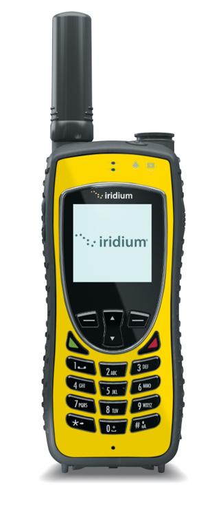
(1) The only information we have about this tragic death is what we have read in the online media reports. References to those are provide at the end of this blog article. We point out that Nature Trail does not contribute in voluntary Search and Rescue activity per se, except if we’re in the field and asked in an emergency situation to assist then of course we would/will support by way of limited temporary coms (we carry a Telstra satphone – Iridium Extreme Model 9575, as shown below).
Plus navigation and any first aid support; but to then quickly return to our prime responsibility for our tour guests to best manage the trip risks. Search and Rescue is a government responsibility for paid professionals.
(2) Avoiding Separation on a Trip
Here’s a tale of previous hiking separation and its consequences:
[Source: ‘Mountains Mishaps’ (book), p.104 ]
We at Nature Trail carry in UHF radios in order to facilitate such an arrangement with reliable remote communications in the field. – two UHF/CB radios are delegated on our hikes and one is permanently installed in our tour vehicle. All three connect by two-way voice transmission when set to the the same channel frequency.
These communication tools enable remote communication by UHF for line-of-sight to 4km+ when mobile phones are outside cell phone reception. This technology continues to provide a vital communications back-up in the field in remote areas.


(3) We at Nature Trail have hiked this Lockley Track at different times and in both directions between Flat Top (off Mount Hay Road) and the Blue Gum Forest. We have also backpacked camped at Acacia Flat camping ground which is situated about 1km south of the Blue Gum Forest.
(4) At Acacia Flat camping ground there are no facilities. It’s just a well established small flat semi-cleared remote reserve and close to and west of Govetts Creek. It is to prevent hikers camping in the nearby and highly valued Blue Gum Forest. We wouldn’t recommend drinking the water out of Govetts Creek since it is downstream of stormwater from the townships of Katoomba (including the tip) and of Blackheath.
(5) If Nature Trail had been asked to lead this hiking trip, well we would not have recommended the route chosen by these two lads. The hiking along Mount Hay Road is not only boring. It is expose to hot direct sun (no shade) and also is inherently dangerous due to pedestrians sharing this windy dirt road with vehicles that from our experience travel at speed. There are better hiking routes in and out of the Grose Valley.
(6) A preferred hiking route to Blue Gum Forest would normally be from Govetts Leap Lookout at Blackheath down via Rodriguez Pass track (except that track has long been closed by the Parks Service for a decade due to landslips and with no sign or intention to have it repaired and reopened.
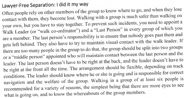
The old Horse Track down from Evans Lookout to Govetts Creek and via Junction Rock would be the better option. The photo below is of a hiking track sign near the Evans Head Lookout atop the eastern end of the Grand Canyon track. The sign points to the right (southerly) to the Grand Canyon track options. The Horse Track top trackhead starts directly behind this sign along the clifftop about 20 metres beyond and descends left (northward down into the Grose Valley).
The Horse Track trackhead junction near Evans Lookout., Blackheath. [Source: Photo by author, 2016-02-28]
However, from our direct hiking experiences, although the old Horse Track is reasonably discernible, it is very steep and uneven in many parts around the top sections.
However, worse is that approaching the valley floor, due to be track route long having been unmaintained by the custodial Parks Service (NPWS) upon the tracks connection with the Grose Valley floor at Govetts Creek, the then Govetts Creek track (Rodriguez Pass track) poses a risk too.
Due to recent bushfires let burn or lit by the Parks Service (2006, 2019) the grass along the hiking track railing Govetts Creek is very overgrown, so susceptible to snakes, so therefore to the risk of snake bite.
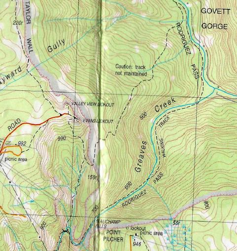
A bite from a local Eastern Brown snake there is deadly – just minutes to live! Yet the Parks Service cares not and neglects maintaining the safety of the track for hikers. “Caution: track not maintained” is even a permanent description on the KATOOMBA 8930-1S topographic map. [Grid Ref: MGA-5274] (See map extract below).
(7) Alternative hiking exit tracks up and out of the Grose Valley from Acacia Flat camping ground are:
(Option a:) Perrys Lookdown – northward along Govetts Creek Track via Blue Gum Forest then at a track junction NW up Perrys Track up Perrys Lookdown
(Option b:) The Horse Track – Back tracking the Horse Track
(Option c:) Lockley’s Track – backtracking same route up to Mount Hay Road
(Option d: Pierces Pass – northward along Govetts Creek Track via Blue Gum Forest then at a track junction
(Option e:) Rodriguez Pass – (currently only if you want to illegally run the Parks Service gauntlet. We’ve been known to. 😎 Fines apply so don’t caught.
(Option f:) Victoria Falls – northward along Govetts Creek Track via Blue Gum Forest then railing the Grose River NW to Burra Korain Flat and climb to Victoria Falls and to Victoria Falls Lookout.
(Option g:) Mount Banks – up the old Gordon Smith Chimney below Mount Banks (but that is dangerous and unmaintained and not recommended. It is beyond rock scrambling up the escarpment cliff and really only for experienced rock climbers.
Such options are mostly further distance hiking routes, so in most cases another 1-Day or 2-Day trip extension to the 3-Days. Distances can be estimated on the relevant topographic maps.
Such options also require transport logistics since the train stations are many kilometres away and the area around the circumference of the Grose Valley is not serviced by taxis so days more track hiking and dangerous road/highway-walking to reach any railway station.
(8) We also would not have undertaken this trip when the weather forecast was to be over 30o Celsius, as it was. And that was a shade temperatures maximum not full sun temperature which is typically much higher. For health and safety reasons this is a Nature Trail policy. Nor do we hike in thunderstorms or snow for that matter. Others can if they so choose.
In all practicality and safety (especially for hiking) the forecasting of Sun Temps are more vital than Shade Temps! How many hike in full shade? Yet how many so perish from heat stroke as a result of the BOM-substandard forecasting of maximum shade temperatures? Compare the 1998 Sydney to Hobart Yacht Race weather forecast of just average wave height, but not about maximum wave/swell height. Think about it.
(9) So the current president of the Upper Blue Mountains Bushwalking Club, Sonya Muhlsimmer, said it was possible to become lost near the popular campsite.
“It can be a wild sort of an area. There’s a couple of footpads [narrow tracks] down there, if you just wander off, you might not be able to find that little track again. It’s quite easy to get disorientated and lost.”
Well, at least this so-called bushwalking club has a new president since its honorary canyoning president resigned since the Wollangambe tragic deaths. Good.
Yes, Lockley Track between Lockley Pylon (hill) and Acacia Flat (valley camping ground) is a goat track down a sun-exposed rocky spur. Best avoided on hot days and especially in the afternoon since the western sun hits it perpendicularly.
(10) So, Lockley Track from Mount Hay Road descends a steep rocky hiking goat track down a spur northward into the Grose Valley toward the Blue Gum Forest. This is the relevant topographic map again. Here’s the relevant extract (track bottom to top) of the subject trip where the separation likely occurred during extreme heat hiking down exposed Lockley Track is blistering hot extreme direct sun toward Govetts Creek and Acacia Flat. (shown of map below).
Count the contour lines between Du Faur Head and Govetts Creek. (The vertical contour interval being 10 metres).
(11) The president of the Upper Blue Mountains Bushwalking Club, Sonya Muhlsimmer, said she was relieved one of the teenagers was rescued thanks to their PLB. “It can literally save your life, I wouldn’t go out without a PLB,” she said.
Yes, that’s wise advice. A GME Accusat MT610G (Personal Locator Beacon) is the best brand/model .
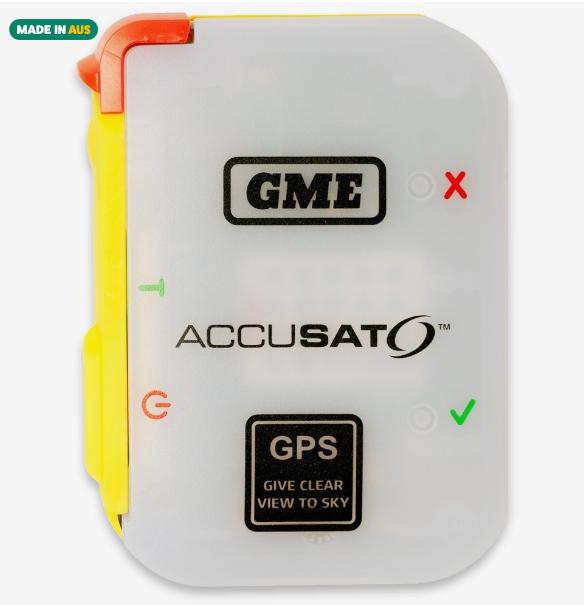
We recommend shopping at Snowys – https://www.snowys.com.au/
(12) This president of the Upper Blue Mountains Bushwalking Club, Sonya Muhlsimmer also urged walkers to tell others their hiking plans and be prepared to navigate without technology. “Have a map you can use offline, have your PLB, and don’t separate from anyone.”
Yes, mobile phone reception is non-existent down in the Grose Valley, even with the best reception of the Blue Mountains being from Telstra’s cellphone network.
However, from where to purchase non-technology paper topographic maps these days? No-one sells them anymore. Nature Trail possess all the topographic maps of the entire Blue Mountains World Heritage Area, costing us over $500. They are scaled 1:25000 and include a aerial ‘orthophoto‘ map on the reverse side. We might be the only ones with such a comprehensive map kit. We have doubled-sided cover these maps with Contact adhesive to make them waterproof and infinitely durable. It’s a professional approach.
(13) The choice of public transport is not ideal, but supposedly the most affordable option. These two lads may not even had a drivers license anyway.
Well, was this trip wise? We suggest not. Yet nothing changes and visitors keep dying unnecessarily. We just feel so sad once again.
(14) One recalls participating in a previous hiking trip into the Grose Valley from near Medlow Bath airstrip (via Juggler and Grand Canyon) to the Acacia Flat camp and thence the next day climbing up Lockley Track over the rocky ridge of Du Faur Buttress and Du Faur Head to Mount Hay Road.
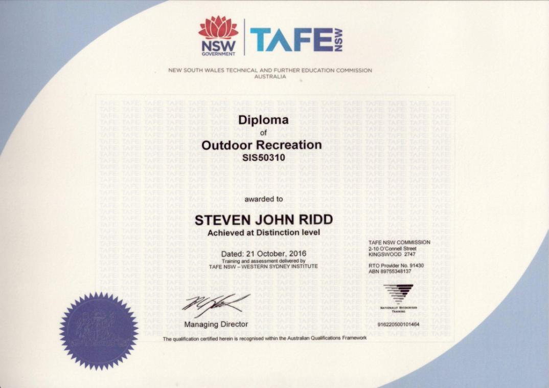
It was a group (say 10 participants?) overnight hike of 8th and 9th March 2015. It was with Blue Mountains TAFE (Wentworth Falls) as part of this author’s since gained Diploma in Outdoor Recreation. (See copy below)
Whatever!
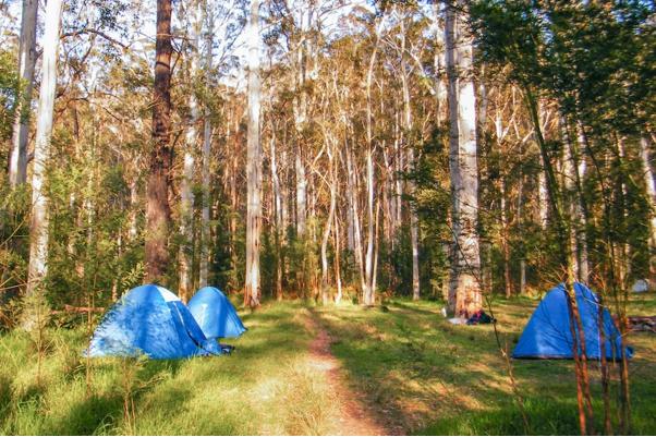
Acacia Flat camping ground
But it was not a good experience due to the poor decision making of the then responsible teacher in the field, one Adam Darrah. He had delayed our TAFE training group by hours on two occasions (Day 1 and then Day 2) by rattling on to us students about some hiking theory interpretation of his. Ego has no place on hiking or in Outdoors Recreation, especially during hiking training trips with incumbent students.
The hiking route chosen was similar to that taken by the two teens of focus in this herein article, yet in reverse direction. The route chose by Mr Darrah was via Grand Canyon Road at Medlow Bath near the Katoomba Airfield, then down railing the Juggler Canyon to connect up with a lower section of the Grand Canyon Track, thence on to Acacia Flat to camp overnight.
The ambient temperature also was similarly horridly hot, particularly in the afternoons.
In the morning after our TAFE group camp at Acacia Flat, the teacher preached some sermon for hours about some Outdoor Recreation theory topics that one doesn’t recall. So it pretty much was a waste of time. Then after he was finished at around lunch time it was hot at 30o+ Celsius and we were required to ascend out of the Grose Valley with full backpacks up the exposed Du Faur Head spur in extreme afternoon heat in full sun with no shade.
What a bloody reckless idiot! So one had lodged a formal complaint for observed instances of negligence by this particular teacher following the trip.
Yet, my complaint about this teachers’s reckless behaviours (and they were multiple) was not dealt with at all by the TAFE Wentworth Falls college. Every detail remains on file for the record. Instead, one received the following glowing award, which upon reflection, one takes as an undeserved censorship of the complaint. I was far from distinction on that course. I was 50 years old and not as fit as the 20-something year olds participating.
In contrast to TAFEs’ reckless and dangerous decision of its hiking/camping instructor to venture in extreme afternoon heat conditions, experienced hiker, rock climber and canyoner Ken Eastwood, a local to the Blue Moutains recommends hking the Blue Gum Forest on winter mornings.
We highlight the following extract from his 2024 guide book ‘Top Walks in New South Wales’ in this case ‘ The Blue Gum Forest’ at page 113.
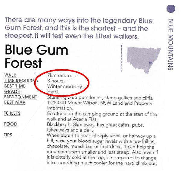
Mr Eastwood recommends the hiking route from Perry’s Lookdown and return, not Lockleys Track.
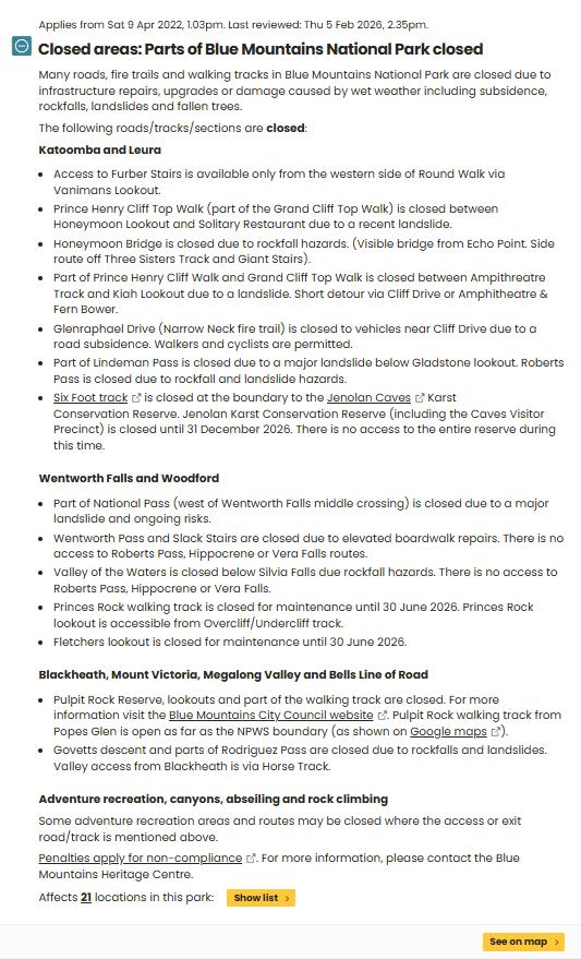
(15) The following is the current alert notice by the NPWS online about closed access to the Blue Mountains National Park. The closures are chronic and makes any trip planning unreliable.
(16) Now what online websites sell Blue Mountains “adventures”?
‘Gum Forest Trail Loop‘, by All Trails, https://www.alltrails.com/trail/australia/new-south-wales/blue-gum-forest-trail-loop
And:
‘10 Best Blue Mountains Walks‘, https://www.bmac.com.au/blog/best-blue-mountains-walks …
Lockleys Pylon to Govetts Leap (via Blue Gum Forest)
“This Blue Mountains walk is a committing day walk or an overnight hike for the adventurous. The walk to Lockleys Pylon offers some of the most spectacular views of the Blue Mountains across the Grose Valley wilderness. The open heathland of the ridge tops closes in on your rugged descent into the Grose Valley as you enter the forests of the valley floor. The Blue Gum Forest, nestled in the depth of the valley, is one of the most renowned bushwalking sites in Australia as a result of its beauty and history as a catalyst for the Blue Mountains National Park being realised. Continuing past Acacia Flats campsite and on to Junction Rock you now begin your climb out of the valley towards Govetts Leap. In time, the serious climbing begins up the epic Rodrigues Pass, which at times clings to the sheer walls of the escarpment. Not to be missed by the adventurous.”
Hey dudes, Rodriguez Pass has been closed for years!
What would Nature Trail have done?
(1) Well, as a professional ‘commercial’ tour operator based in Katoomba, Nature Trail would start well in advance (weeks) in dialogue with the two as paying tour guests. to discuss their trip intentions and aims (each of them separately).
- Each of their hiking experiences – where, distances and when?
- Their fitness regimes and levels?
- Each of their overnight trekking experiences – where, distances and when?
- Their respective hiking/backpack camping kits, water, food, safety gear, transports?
- Their trip intentions?
- Their trip aims? Just do Blue Gum Forest?
- Their intended duration? Why 3-days?
- Their budget? Our daily fee to lead a trek group (min 4/ max 6 pax) would be AUD$50 plus full fuel tank cost divvied up ($120), but each participant would need to be wholly experienced in trekking, self-reliant/self-sufficient – with kit, shelter, sleeping, gear, water, food (and to prove it to us in advance). Clearly, we’re not in this for profit, just sharing safe trips and cost recovery.
(2) We would offer our informed suggestions about the best options (location, route, timing, logistics, kit, expectations, risks) – all in writing by email to both.
(3) A Trip Agreement (with our terms and conditions) would be drafted and communicated – in writing to both, well in advance, requiring acceptance by signatures and witnesses to those signatures. Route options would be included, timing would be pending availability and environmental conditions (including weather). Credit card full pre-payment would be transacted in advance with receipts.
(4) We would not have taken the route they chose. There are superior and safer routes.
(5) We would not have timed the trip on the days they chose. The temperatures were forecast to be too hot amd so dangerous to health ad well-being for all.
(6) We may not have proceeded with their trip request at all. For remote safety we only undertake hiking/trekking trips with between 4 and 6 participants, never just 3, 2 or 1 participant.
(7) The credit card full pre-payment would be duly refunded in full.
(8) In any case, Nature Trail would not accept any legal minor (under 18 years of age in Australia) on any of our hiking/trekking trips, even with parents.
The risks, problems, insurance and consequential legal implications are unacceptable. Such has been demonstrated in this particular case. We at Nature Trail do hiking, not legal drama. Others are happily welcome to take on such stupidity at their peril.
“Mad Dogs and Englishmen” are traditionally and foolishly renown to go out in the mid-day sun.
Further Reading and References:
[1] ‘In Loving Memory of Andre Marquez‘, GoFundMe, https://www.gofundme.com/f/in-loving-memory-of-andre-marquez
“Andre was an adventurous boy, full of joy and laughter. Unfortunately, he went missing around 3pm Wednesday 28/1/26 during a hiking trip with his mate in the Blue Mountains. At 1pm Thursday 29/1, his deceased body was found in a creek.He was a boy with many aspirations and achievements. He was a Leading Airforce Cadet, who had many younger cadets that looked up to him. He was a black belt in Karate, a sport of discipline and strength. He wanted to get into ADFA to study Aeronautical Engineering. He was not only smart in academics, but he knew all sorts of survival skills; swimming, first aid, camping. He was a boy with a shining bright future.Andre had a kind heart, a friend and comforter to everyone who crossed his path. He always saw the positive in things and only wanted peace for the world.We are raising money for his funeral, to honor his impact on everyone. A young and special soul, who will forever be 16.”
– Marquez Family
[2] ‘Teenage bushwalker found dead in the Blue Gum Forest in Blue Mountains National Park‘, Friday 30th January 2026, by Lani Oataway, ABC media, https://www.abc.net.au/news/2026-01-30/teen-bushwalker-found-dead-in-blue-mountains/106285992
[3] ‘Teen’s body found after Blue Mountains camping trip disappearance‘, 30th January 2026, by Jorge Branco, 9 News (media), https://www.9news.com.au/national/blue-mountains-hiking-teens-body-found-after-camping-disappearance/613cd48c-40bf-418f-a6f1-9c37a5d85a22
[4] ‘Teen hiker found dead in Blue Mountains tragedy‘, 7 News (media), https://7news.com.au/video/news/teen-hiker-found-dead-in-blue-mountains-tragedy-bc-6388531555112
[5] ‘Teen found dead on Blue Mountains hike camp trip named‘, 3rd February 2026, by David Wu, News (media), https://www.news.com.au/travel/travel-updates/incidents/teen-found-dead-on-blue-mountains-hike-camp-trip-named/news-story/96d8da0c5a4292ba943e5c8b200f315e
[6] “Mountains Mishaps: Death and Misadventure in the Blue Mountains of NSW’, 2023, by Christopher Webber, (documentary book), published by Carmarthen Highlands Press, Katoomba, Blue Mountains, Australia, ISBNs: 978-0-6458099-0-9 (paperback) | 978-0-6458099-1-6 (e-book), https://mountainsmishaps.com.au/
[7] ‘Reading a Grid reference from a Map‘, National Parks Association, https://www.bushwalking101.org/grid-references
[8] ‘Bushwalker death: 000 staff went unpunished‘, 17th April 2009, by ABC (media) https://www.abc.net.au/news/2009-04-17/bushwalker-death-000-staff-went-unpunished/1653024]
[9] ‘GME Accusat Personal Locator Beacon (PLB)‘, https://www.gme.net.au/au/emergency-safety/mt610g/
[10] ‘Mount Hay Road Leura‘, by (NSW Government’s) NSW National Parks and Wildlife Service (website), https://www.nationalparks.nsw.gov.au/things-to-do/cycling-trails/mount-hay-road-leura
[11] ‘The Basics of Navigation‘, 17th
[12] ‘Coroners Court New South Wales‘, (website), https://coroners.nsw.gov.au/coroners.html#:~:text=Her%20Honour%20Magistrate%20Teresa%20O,Main%20Avenue%2C%20Lidcombe%20NSW%202141.
[13] ‘1998 Sydney to Hobart Yacht Race‘, https://en.wikipedia.org/wiki/1998_Sydney_to_Hobart_Yacht_Race
[14] ‘Snowys Outdoors‘, (Australian retail shop for hiking and camping gear – shelters, packa and bags, lightweight sleeping gear, hike accessories, cooking, hydration, hygiene and safety, hiking clothing, etc – all made in Australia), https://www.snowys.com.au/
[15] ‘Sports and Hydration for Athletes: Q&A with a Dietitian‘, by Rayven Nairn, https://www.hopkinsmedicine.org/health/wellness-and-prevention/nutrition-and-fitness/sports-and-hydration-for-athletes
[16] ‘Blue Mountains Best Bushwalks‘, 4/e, by Veechi Stuart, 2022, published by Woodsland Press, in paperback print form, 280 pages, retails for $35, https://www.paddypallin.com.au/blue-mountains-best-bushwalks.html
“The thoroughly revised fourth edition of the bestselling Blue Mountains Best Bushwalks is the perfect companion for the bushwalking fan. The book features: 67 different walks, varying in length from 30 minutes to two days, accurate, full colour maps and step by step directions, detailed walk statistics including distance, total ascent/descent, grade and estimated time, detailed information on Blue Mountains history and natural environment, walking ideas for families with children, including safety tips, and over 200 full colour photographs. With over 4 million Australians now regularly walking for fun and fitness, this guidebook is the perfect companion for any Sydney-sider looking to bust out of the city and explore the raw beauty of the NSW Blue Mountains.”
[17] ‘Top Walks in New South Wales‘, by Ken Eastwood, 2ed, 2024, published by Hardie Grant Explore, Sydney Australia, https://publishing.hardiegrant.com/en-au/books/top-walks-in-new-south-wales-2nd-edition-by-ken-eastwood/9781741178265
[18] ‘The Blue Mountains on foot‘, 2ed, 2001, by Bruce Williams and Reece Scannell, published by New Holland Publishers (Australia) Pty Ltd, paperback book, retails for AUD$22, https://www.dymocks.com.au/blue-mountains-on-foot-by-bruce-williams-and-reece-scannell-9781864365306
[19] ‘Blue Mountains for World Heritage‘, 1989, by Geoff Mosley, paperback printed book, published by Colong Foundation for Wilderness, Sydney, Australia, ISBN 0 9599347 3 1, Library Dewey code: 333.7816099445.
[21] ‘Top Walks in New South Wales‘, 2ed, 2024, by Ken Eastwood, hardback 360 pages, published by Hardie Grant Explore, ISBN 978 1741178265.
[21] ‘Mad Dogs and Englishmen‘, song by Noel Coward, ℗ 1928 His Master’s Voice Released on: 1928-02-03 Composer: Noel Coward Lyricist: Noel Coward Music Publisher: Chappell Music Ltd, provided to YouTube by Zebralution GmbH Mad Dogs and Englishmen · https://www.youtube.com/watch?v=6lEkHonfL7E