We sense that the ‘Climate Cult’ fad continues to promulgate its ideology propped up in overloaded government bureaucracies

At times, Nature Trail’s motivation in this magazine blog is triggered to write a pensive piece and share some reflections of our own with readers. But we’re not religious and certainly not evangelical.
The particular trigger in this case has just been a reflection of us here in Katoomba emerging from a widespread impacting torrential rain event over the past 24 hours, but unforecast.
So much so, one took a computer Internet satellite image of this rain event today as it continued to saturate our region all the way 100km inland to us from the Pacific Ocean coast off Sydney. Such events are in Sydney and beyond into affected hinterlands locally as an ‘East Coast Low‘. [See map below]
In Katoomba, this weather system has been going on for the past 24 hours or so.
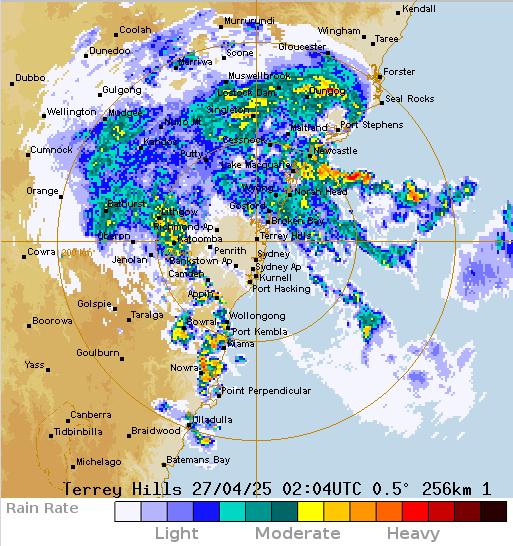
SOURCE: Australian Government’s Bureau of Meteorology website, Sydney Radar, 2025-04-27
This is a recurring meteorological rainfall pattern event that typically stays overhead of a particular widespread region (often Sydney) in a slow clockwise swirl dumping heavy rain for hours on end.
We emphasise that there was no wind, rather just heavy concentrated rain over this wide region for many hours. It was not a cyclone nor a hurricane, just another Australian ‘East Coast Low‘.
In this case today, heavy rainfall from this moist low-pressure ‘cyclonic’ (clockwise slow spin) system continued to plummet and linger (not technical terms) extending some 600 km in diameter between the coastal town of Forster in the north to inland Katoomba (we we are) and further west out to the inland township of Mudgee, then also south to impacting down to the NSW the coastal township of Ulladulla.
We acknowledge that whilst we are not meteorologists nor weather experts, it would seems logical to us that this East Coast Low has been like many lingering over the years impacting Sydney’s widespread coastal ‘basin’ and hinterlands beyond. Our short online research shows that such East Coast Lows are mostly influenced by the weather conditions associated with the adjoining massive Pacific Ocean directly off the east coast of Australia. However, we stand to be corrected.
Our concern as a tour operator in the Blue Mountains, is that such a heavy rain event had not been adequately forecasted by the responsible Australian Government department responsible. So this posed a serious safety risk to many reliant upon trusting such expert analysis for their safe operations in the great outdoors, especially to overnight campers.
For instance, what if Nature Trail had been on a hiking tour at the time, had checked the weather forecast on the BoM website as ‘mild’? Yet then our actual unforecasted inclement weather experience would have been far worse.
What if this unforecast torrential rain had forced us a last minute tour cancellation? Worse, what if whilst on tour this actual (unforecast) torrential rain and cold had directly caused physical suffering to our unprepared guests – such as hypothermia for instance? This would have triggered an emergency.
On Saturday 26th April 2025, the Blue Mountain actually copped unforecasted torrential rain for hours (perhaps 200mm) and the temperature plummeted down to 8o Celsius overnight. Such weather conditions when remote hiking and camping can become life threatening to those exposed in an outdoors remote hiking environment.
Outdoor Recreation deserves reliable weather forecasts for the safety of each and every outdoor trip. The BoM doesn’t estimate rainfall levels, rather offers just vague guesstimates of percentage chances of rain. We recall that back in 1998, the BoM only provided estimate average wave heights in the Tasman Sea to the Sydney to Hobart sailing fleet. It’s guesstimates of 7 metres were so misleading. In fact, there was a major storm and a rescue helicopter reported a wave of 44 metres in height at the time.
The 1998 race was the most disastrous in the race’s history, with the loss of six lives and five yachts in an unexpectedly severe storm on 27–28 December 1998. Had maximum wave heights been forecast, the race would have certainly been cancelled before it started.
Try suing the BoM for wrong weather forecasts as direct result of its incorrect weather forecast reporting causing our guest(s) physical suffering, injury, remote emergency evacuation costs to hospital, or worse, death.
Our Blue Mountains weather varies throughout each given year, but more or less remaining generally predictable, mostly. Situated on a semi-inland plateau (at 1km above the ocean and 100km inland west of Sydney) we get relatively mild summers and also cold winters which occasionally bring snow under the right ambient moist air conditions if the temperatures from the New South Wales (NSW) inland ranges drop to freezing.
In the Mountains, we have’t yet copped a doomsday Book of Relevations like ‘global warning’ nor ‘global cooling’. Rather its just changing weather on a seasonal basis, and occasionally and expectedly influenced by periodic oscillating Pacific Ocean La Niñas and El Niños. It’s all good, and so we appropriately dress for the seasons.
Our Mountains continues to receive seasonal rains, winds, storms, then after the rain, typically low thick cloud blankets hanging over.
Actually, to prepare us better for this known recurring low-cloud event, Nature Trail is next week finally having proper yellow flog globes installed on our Range Rover where the current white driving lights are positioned low to the road but useless in fog. It’s to cut below the fog line for safety.
The seasonal weather variety is comparable to many other regions, each having their own characteristic, prevailing conditions and weather patterns, we’ve noted in may cases of travelling.
Mostly, weather generally variability remains all very normal, and rather expected just with the occasional extremes. It has been going on for decades, hundreds of years and indeed over millennia. It’s just like Humans have always had two arms and two legs for the last 200,000 years evolving from Homo Erectus and prior. So, no news here and frankly nothing to be alarmed at.
We observe that Gen-Z hasn’t yet evolved with huge thumbs due to the advent of habitual mobile phone texting since Nokia’s first SMS mobile launched back in 1993. Evolution and the Earth’s Climate has evolved and continues to do so, but not so radically like since just a lifetime ago when the alarmist cult of Al Gore’s 1976 pronouncement of ‘global warming’ became akin to a fear-mongering religious Revelation 18:1–8 of impending planetary doom.
We recognise that broader longer-term weather patterns occur beyond the four seasons and that these are similarly timeless, recurring and predictable. Like, Dorothea MacKellar was right in her poem of 1908 “My Country” (originally she entitled it entitled ‘Core of My Heart’) – with the famous impassioned stanza:
“…I love a sunburnt country,
A land of sweeping plains,
Of ragged mountain ranges,
Of droughts and flooding rains….”
At a Federation time of a new Australia from 1901, this immigrant girl’s impressionable experience of Australian life growing up in the countryside and witnessing the extremes of weather (near rural Gunnedah, NSW)
After a period of proven scientific La Niña brought heavy widespread torrential rain along the east coast of Australia 2020-2023, BoM’s long range forecast guesstimates in late 2023 predicated an oscillating phase of the El Niño dry spell into 2024 and beyond.
Anyone stepping outside is entitled to lick their index finger into the ambient air and do same – “what is the weather about to do?”

Testing for climate change or just reference to a higher bean… ‘climate scientology!!’
However, to better predict what the weather might do in just the next few hours, one prefers to rely more upon a tad more established scientifically-proven set of weather measuring instruments such as a barometer, hygrometer, rain gauge and good old wind sock.
However, the weather the very next day may well change like the wind, let alone how can we guess it might do next year? Yet, Canberran BoM’s long range weather forecasters reckon they can predict over the horizon like having a direct link to God or Druidism.

BoM would get one of these if allowed
The BoM are oft proven wrong, but the of course quick to apply blame for their theory to others or dark forces. It’s only to justify their jobs and pay packets with perks only public servants can muster.
Back on 19th September 2024, the Bureau of Meteorology formally announced an El Niño event for Australia during the 2023/2024 summer. BoM’s official public ‘Henny Penny‘ sky falling in doomsday warning of 20th November 2023:

“..parts of Australia will likely experience warmer and drier conditions with minimal rainfall, increasing the risk of heatwaves and fire danger.”
The health and wellbeing of our students and staff is paramount. In the lead up to and during summer, we’ll follow the forecasting guidelines of the Bureau of Meteorology (BoM) to ensure our community stays safe during extreme weather. We have emergency responses in place in the case of severe heat, poor air quality and bushfire events.
We will proactively communicate with you when there is a change to campus access and activities due to weather-related conditions, and what you need to do to stay safe.
________________________________________
If you need help
Visit the NSW Health website to learn the signs of heat-related illness and when you might need to seek medical help.
If you develop symptoms related to extremely poor air quality or severe heat and are concerned about your health, please call the 24-hour HealthDirect helpline on 1800 022 222 or in an emergency call triple zero (000) for an ambulance.
Our student wellbeing team offers a range of confidential and free health, wellbeing, and personal support, and is available 24/7.
________________________________________
There are a number of precautions you can take at home, on campus, or while travelling to protect yourself from extreme weather.
Beat the heat
An El Niño increases the risk of unusually hot weather and heatwaves. Warmer weather can affect everyone; however, some people are at greater risk than others.
Our Central Operations Services team has reviewed the available air-conditioning systems across our campuses, and where the best indoor locations on campus are for offering respite from the high temperatures outdoors.
Teaching and exam spaces have been prioritised to ensure minimal disruption if you’re studying over the summer, and when you return in Semester 1, 2024. If you require adjustments, please visit the special consideration webpage for more information.
University libraries will be closed during the shutdown period, 23 December 2023 to 7 January 2024.For opening times outside of the shutdown period at each library, please check the Library website.
Air-conditioned study spaces on our campuses that are open 24/7 are:
• Abercrombie learning hub
• Brennan MacCallum learning hub
• Carslaw learning hub East
• PNR learning hub
• Camden access labStay hydrated
Keep cool
Plan ahead.
Read commentary on the BoM website from CSIRO experts explaining what we know about the strength, behaviour, and significance of this El Niño, along with what it means for the climate and the world more broadly.
NSW Health has tips and resources available to manage your mental health during bushfire season if you’re experiencing anxiety or feelings of not coping.”
Grain of salt! BoM’s Armageddon climate model theory didn’t eventuate. The sky did not fall in. Instead New South Wales copped more east coast low rain events. Woops!
Then by 15th October 2024, weather reality finally kicked in for the BoM bureaucrats from their climate scientology inner sanctum headquarters in its Canberra:
Quote:
“La Niña is becoming less likely, Australia’s weather bureau says”
The Canberra BoM Arch Druid:
“The likelihood of a La Niña weather event in coming months has decreased, Australia’s weather bureau said on Tuesday, adding that if the phenomenon did appear, it would be weak and short-lived.
“The chance of a La Niña event developing in the coming months has decreased,” the Australian Bureau of Meteorology (BoM) said in a two-weekly update.
The bureau said its in-house climate model suggests La Niña will not develop and four of the six other climate models it surveys now agree.

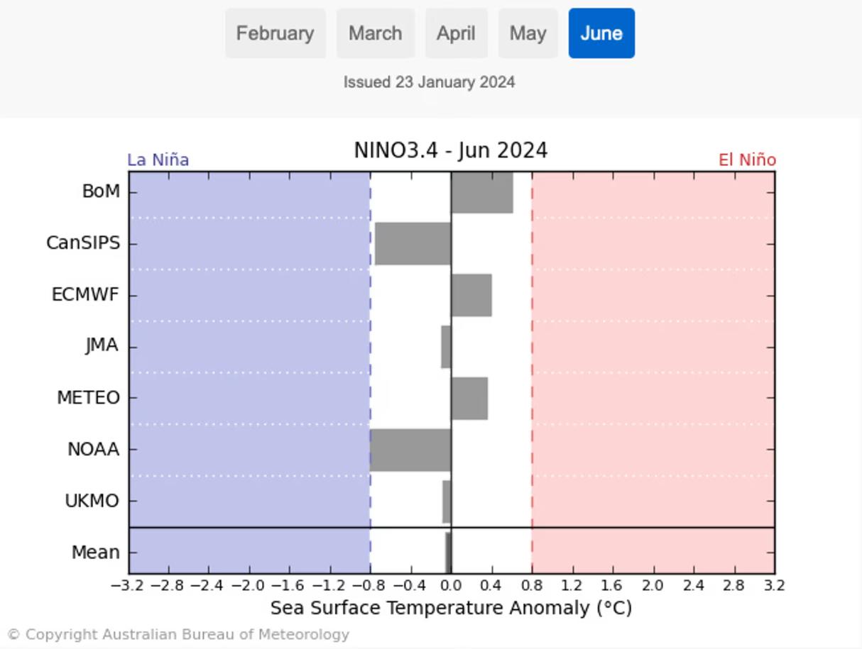
Canberra’s BoM 2014 El Niño prediction was globally the most extreme
International climate model forecasts for June 2024. Photograph: Bureau of Meteorology
Since 1900, half of the years have featured either a La Niña or an El Niño, and there’s about a 40-50% chance that an El Niño will be followed by a La Niña, the person said.

Did BoM get it wrong? Blood oath!
Nine months later, the insular Bureau of Meteorology Druids in September 2024 (kicking a screaming) ultimately joined other global weather agencies to declare an El Niño event to be under way in the Pacific. Then widespread, and in some cases flooding, rains arrived in December.
BoM Excuse Propaganda Sub-Agency:
“The bureau’s website makes it clear El Niños “usually” reduce rainfall across the eastern and northern parts of the continent. It’s not a certainty.
Wenju Cai, a leading CSIRO researcher before his recent retirement (about time), says that there have been La Niñas and El Niño years after each other. However, “I don’t see any analogy in history – of three La Niñas, an El Niño then switching to another La Niña,” Cai said. “If I had to flip a coin, I’d predict an El Niño” for 2024.
Agus Santoso, director of the China-based CLIVAR centre studying climate ocean variability (an ex-CSIRO but now on better pay), said there is “still uncertainty” how 2024 will play out but a return of La Niña can’t be ruled out.
“The chance of a La Niña tends to be higher when we have an El Niño the year before, especially a strong one,” Santoso said. “That is because a strong El Niño tends to leave the upper equatorial Pacific Ocean to be deficit of heat, which is favourable for La Niña to develop.”
Longer-range weather models don’t have the same year-round accuracy because of what’s known as the “predictability barrier” that runs roughly February to May. That’s when the temperature difference, or gradient, naturally diminishes across the tropical Pacific.
“Model outlooks for predictions through autumn and beyond should therefore be treated with caution,” the bureau’s spokesperson said.
Cai agrees that model confidence is “poor” during autumn when trade winds are typically “very weak”. “The whole thing is full of noise,” he says.
Hello! It’s climate gambling theory to prop up bureaucrat ideologists milking the public purse.
Then there’s was this announcement from BoM in April 2024:
BoM declares the El Niño is over and another La Niña ould be on the way
Seven months after an El Niño associated with hotter and drier weather got under way, conditions have returned to neutral.
The Bureau of Meteorology has declared the El Niño weather event of 2023-24 to be over, with odds increasing that its cooler counterpart, the La Niña, will return by the coming spring.
The bureau noted that predictions made in mid-autumn “tend to have lower accuracy than predictions made at other times of the year. This means that current forecasts of the ENSO state beyond July should be used with caution”.
That run of record-breaking heat might also add to the uncertainty about how conditions evolve in the Pacific and the resulting weather impacts.
“The global pattern of warmth is affecting the typical historical global pattern of sea surface temperatures associated with ENSO variability,” it said. “As the current global ocean conditions have not been observed before, inferences of how ENSO may develop in 2024 that are based on past events may not be reliable.”
In a nutshell, are we climate sceptics? Worse than that…full-blown bullshit detectors!
References:
[1] ‘The Bureau of Meteorology has predicted an El Niño this summer: what you need to know‘, 2023-11-20, ^https://www.sydney.edu.au/study/student-life/student-news/2023/11/20/the-bureau-of-meteorology-has-predicted-an-el-nino-this-summer-what-you-need-to-know.html
[3] ‘How likely is another La Niña for Australia in 2024?‘, 2024-01-31, by Peter Hannam, The Guardian newspaper, ^https://www.theguardian.com/australia-news/2024/jan/31/la-nina-weather-pattern-australia-2024-chance-bom
[2] ‘La Niña is becoming less likely, Australia’s weather bureau says‘, 2024-10-15, by Reuters, ^https://www.reuters.com/business/environment/la-nina-is-becoming-less-likely-australias-weather-bureau-says-2024-10-15/
[4] ‘BoM declares the El Niño is over and another La Niña could be on the way’, 2024-04-16, by Peter Hannam, ^https://www.theguardian.com/australia-news/2024/apr/16/bom-el-nino-weather-pattern-classification-australia-over-la-nina