Blue Mountains ‘Grand Cliff Top Walk’ Our Critique – SEGMENT 1: Wentworth Falls Railway Station to Conservation Hut
This Trail Segment 1: Specifications:
| This Nature Trail Tour Title: | Grand Cliff Top Walk Trek |
| NT Tour Code: | MT-GCT/1 |
| NT Tour Code Description: | Multi-Day Trek |
| Tour Category | Tailored |
| Trail Official Opening Date: | Monday 25th March 2024 |
| Tour Current Status: | Scouted> Recce > Trail partial closure, with roadway detour |
| Nature Trail Version: | Grand Cliff Top Walk – Original Bicentennial Version |
| Trek Segment Title: | Weatherboard Inn site to Conservation Hut or vice versa |
| Trek Segment ID: | Segment 1 |
| Trail Hike Length: | 5 to 6 km (depending on lookout choice diversions) |
| Trail Hike Duration: | Allow 4 hours, plus lunch 1.5 hours |
| Trail Hike Length: | 24 km |
| Tour Starting Location: | Wentworth Falls Railway Station |
| Tour Finishing Location | Wentworth Falls Railway Station |
| Tour Style: | Easily paced, interpretative Q&A, photo/rest pauses, physical grades 1 to 3, convenient transfers, |
| Transport Transfers: | Transfers included – available within the Blue Mountains stays/or alternate choice as with all Nature Trail hiking tours and trekking tours by pre-arranged car shuffle at each tour end location. One or two of our tour guests will need to pre-arrange a second vehicle for shuffle (start <> finish). |
| Transfer Distances: | From Tour Start: (Katoomba Railway Station) to Hike Start: 500 m
From Hike End (Conservation Hut ) shuttle back to Hike Start: 3 km |
| Tour Price: | No charge (Free). Nature Trail has decided to no longer seek to operate commercially. Food not included. |
| Nature Trail’s business logo encounted en route has been plagiarised by Council and Parks Service how many times?:
|
13 plagiarised copyright logos
(see below) |
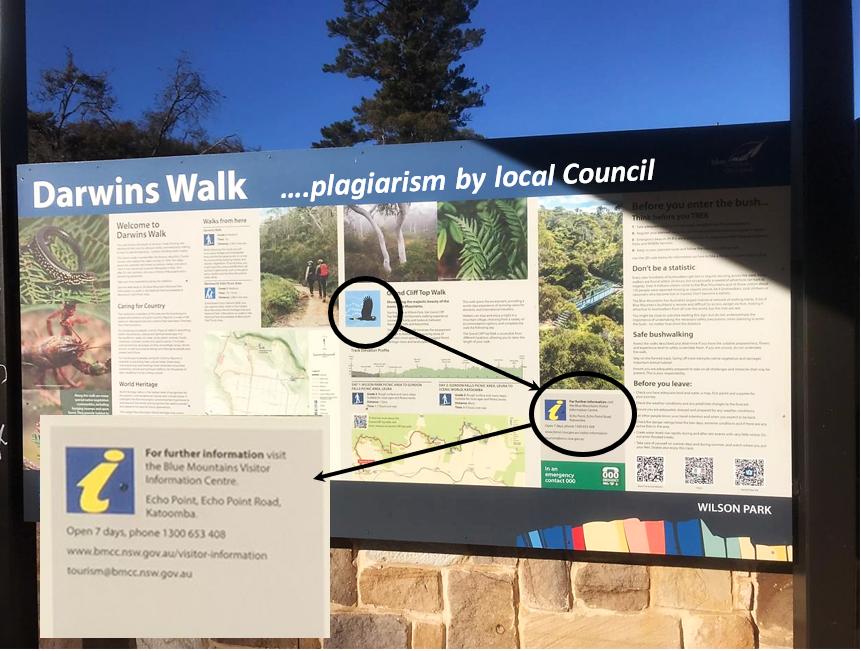
Segment 1: Nature Trail’s ground–truthing reconnoitre of Blue Mountains Council’s so-called ‘Grand Cliff Top Walk’ Segment 1 (Jun-Jul 2025) is photographing and documented wayfinding signage posts of 13 plagiarised replica images of Nature Trail’s business logo en route by jointly Blue Mountains Council (BMCC) and Parks Service (NPWS) .
Nature Trail’s professional touring policy is to first reconnoitre any proposed tracks and trails we consider like this new one before deciding whether the tour route is accessible, consistent with our style and operational policies, worthy, safe, complete and makes for a valued experience to offer to our tour guests.
Nature Trail’s Tour Director, Steven Ridd, author of this critique article series about the 2024 ‘Grand Cliff Top Walk’ trail.
Nature Trail, under its risk management policy always safely undertakes ‘ground-truthing’ reconnoitring before evaluating offering a subject tour. The following photos of this article have been taken by this author Wednesday 18th June 2025, unless stated otherwise.
As an option for offering potential hiking tour options along this trail, Nature Trail is currently ‘ground-truthing’ the recent upgrades to this old trail. We are previously well familiar with the tracks along this trail for many years.
We have already decided to vary the trail’s offering and divided it into 7 half-day segments for our own reasons. We consider from our hiking experience of this trail that by doing so, it’s akin to restoring the tradition of its many interconnecting historic short tracks, which this new ‘mega’ trail seeks to replace, rename and culturally cancel.
Our chosen half-day numbered segments 1 to 7 are just our own discrete identifying labels, but not suggesting any order of travel. This trail is across public land so legally accessible after all, so no hiker is compelled to follow the Park’s Service (NPWS) flyer recommendation to attempt the overall 20+km distance as a half marathon in a ridiculous 2 days!
Have you read the Park’s Service (NPWS) flyer for its 2024 ‘Grand Cliff Top Walk’? This is it – we avail downloadable, and thus re-printable:
 Loading...

Seriously, 20+km in just 2 -days? Parks Service needs to get out more.
We have observed that this new mega trail avoids the best vistas and experiences en route. No signage along this trail encourages any side track diversion and back in order to experience the vistas of the magnificent Jamison Valley below from the cliff top! So who decided to design and rename this series of historical hiking tracks into some ‘Grand Cliff Top Walk‘?
From our ‘ground-truthing’ reconnoitring we are beginning to presume that this fancy 2024 elongated trek concept was done over perhaps drinks from a bureaucrat’s sheltered workshop desk. Like, they’ve never actually hiked this ‘Grand Cliff Top Walk’ end-to-end, if any section at all, so haven’t a clue of the interminable demands of its advertised half marathon.
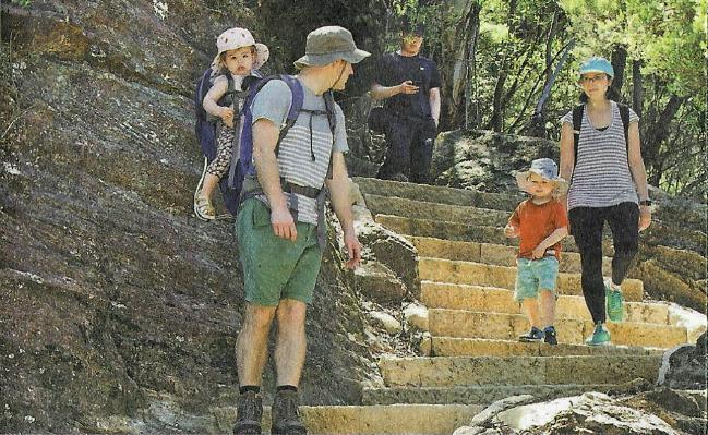
This is Parks Service’s official flyer included photo targeting toddlers to take on its 20+ kilometre half marathon hundreds of stone staircases quest in 2-days.
Nature Trail frankly calls this out as reckless and culpable negligent advertising by this government that is wilfully and wrongfully luring innocent tourists into deadly harm!
Nature Trail has done this trail. We consider this trail attempted in the government’s officially recommended 2-days marathon duration to be life threatening. Take this to your lawyer!
In stark contrast, we refer readers to a very sensible and responsible local hiker’s guidebook for the Blue Mountains, written by local Blue Mountains experienced hiker, Veechi Stuart. Her book is entitled ‘Best Blue Mountains Bushwalks‘ and we have previously purchased editions #2 and #3.
Veechi in this hiking guidebook of her special Blue Mountains hike recommended as: ‘A short walk for young children‘ at page 70. We provide a copy of her guidance thus:
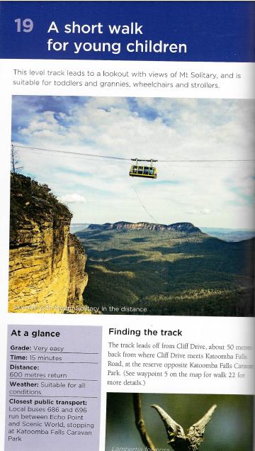
‘At a glance’: Toddlers on a hike with their parents can probably manage a hike of 600m return, not 20+ km one-way!
We offer that each and any of these segments of this ‘Grand Cliff Top Walk’ may be selected by a private tour guest group in any number of segments (even just one), in any sequence, in any direction and at random as they care to choose. Nature Trail is not beholden to the Parks Service official flyer recommendations.
Nature Trail’s Tour Director, Steven Ridd, has hiked all segments of the trail many times since the mid-1990’s and is very familiar with the many track segments of this particular concept trail and many other hiking tracks in this region. He has a lifetime of hiking experience, and is well familiar with the Blue Mountains Region and westward beyond having lived with his family in Katoomba since 2001.
Steven is currently (June-July 2025) ‘ground-truth’ reconnoitring the 2024 upgrades to the overall trail segment by segment at a slow interpretative pace with Friends of Nature Trail, documenting features en route, taking many photos and then writing up a travel journal and critique on this website for each segment. We group this under our Tour Yarns Menu item.
This is a recent concept trail of 20+km in length, and is an amalgamation of many shorter popular hiking tracks, some being historic.
In our current critique (2025) we break this back into manageable segments approximating a half-day each, for flexibility and to divide up our critique into readable articles rather than as a web-book. We offer positives and negatives for readers as hikers.
Trail Segment Introduction:
We begin with the government’s recommended start at Wentworth Falls, which we term ‘SEGMENT 1: Wentworth Falls Railway Station to Conservation Hut‘. The direction may be pre-arranged in reverse.
The hiking distance from a convenient Wentworth Falls Railway Station to Conservation Hut on this trail is about 5km (one-way). This does not factor in a few short side tracks to lookout vistas along the way. So we allow for 6km and a slow pace to savour the journey, so allow say a leisurely 4 hours hiking. This duration of course does not factor in waiting for coffee at Fed beforehand nor for lunch at the Conservation Hut.

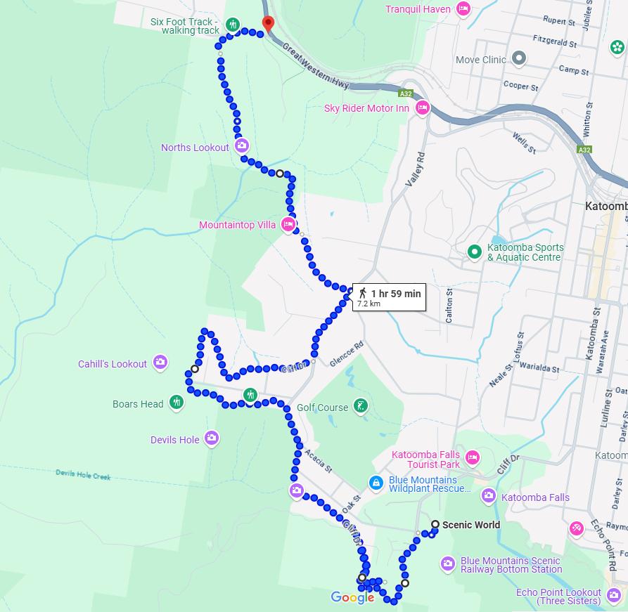
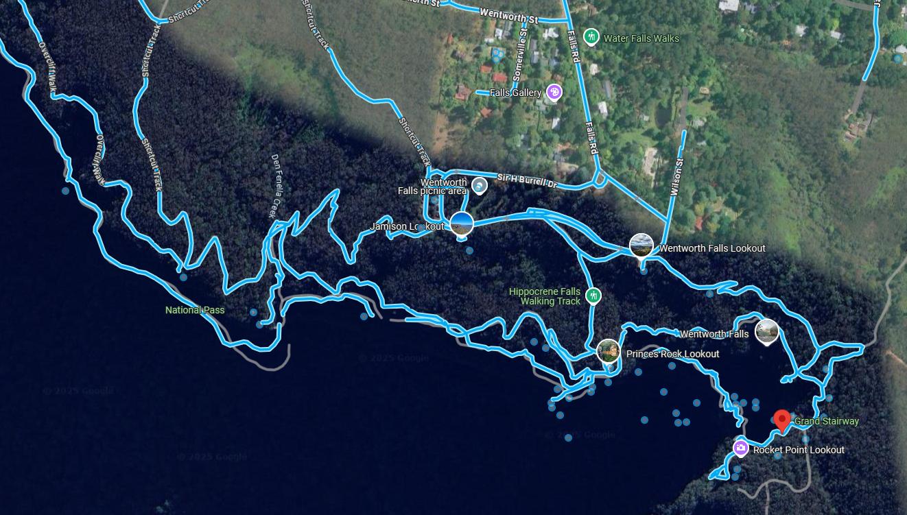
Trail Segment 1: hiking route (shown in blue) starting from top (Wentworth Falls) to bottom (Conservation Hut – shown on left). The 1 hour 14 minutes is a gross understatement using AI. It fails to take account of the many hilly stairway climbs and descents, let alone side tracks to lookout vistas of the Jamison Valley nor pauses and rest breaks. [Source: Google Maps, satellite photo 2025].
Following is Nature Trail’s photo, one of many missed vistas off this government “grand” trail. Both the flyer and the actual trail signage en route of this 2024 Grand Cliff Top Walk fail to mention Fletchers Lookout below.
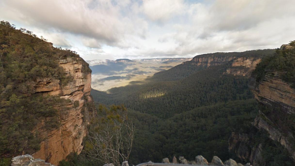
‘Fletchers Lookout’ atop the Wentworth Falls escarpment overlooking the Jamison Valley southward below. Yet this lookout is but a short sidetrack off-course from this ‘Grand Cliff Top Walk’. Why, given government’s fancy new clifftop re-naming?
A suggested gentle interpretative pace at about 2 kph will allow a hiker/small hiking group to complete this Segment 1 comfortably in 4 hours or less. This allows for due energy pauses and scenery breaks to enjoy the natural environment en route and also time to respect the less fit hikers in a generally fit hiking group. So we consider this segment comfortable manageable as a half-day hike for most hikers.
We note that this Segment 1 heads southward and follows most of the original ‘Charles Darwin Walk‘ track perpendicularly to the clifftop edge of the Jamison Escarpment. Then the trail take a westerly direction connecting on to other tracks to the famous Conservation Hut.
Here we explain each of these two sections of Segment 1 in turn.
‘Charles Darwin Walk’ track section:
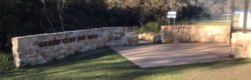
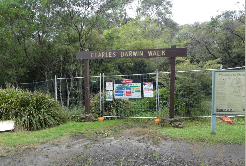
The trail’s officially recommended starting location is at Wilson Park Picnic Reserve and after fours years of closure due to flooding damage and upgrade it now features an improved information board and weather shelter at the start.
This section is entirely on Blue Mountains Council bushland. As we’ve pointed out, the wayfinding signage is a plagarism of Nature Trail’s business logo.
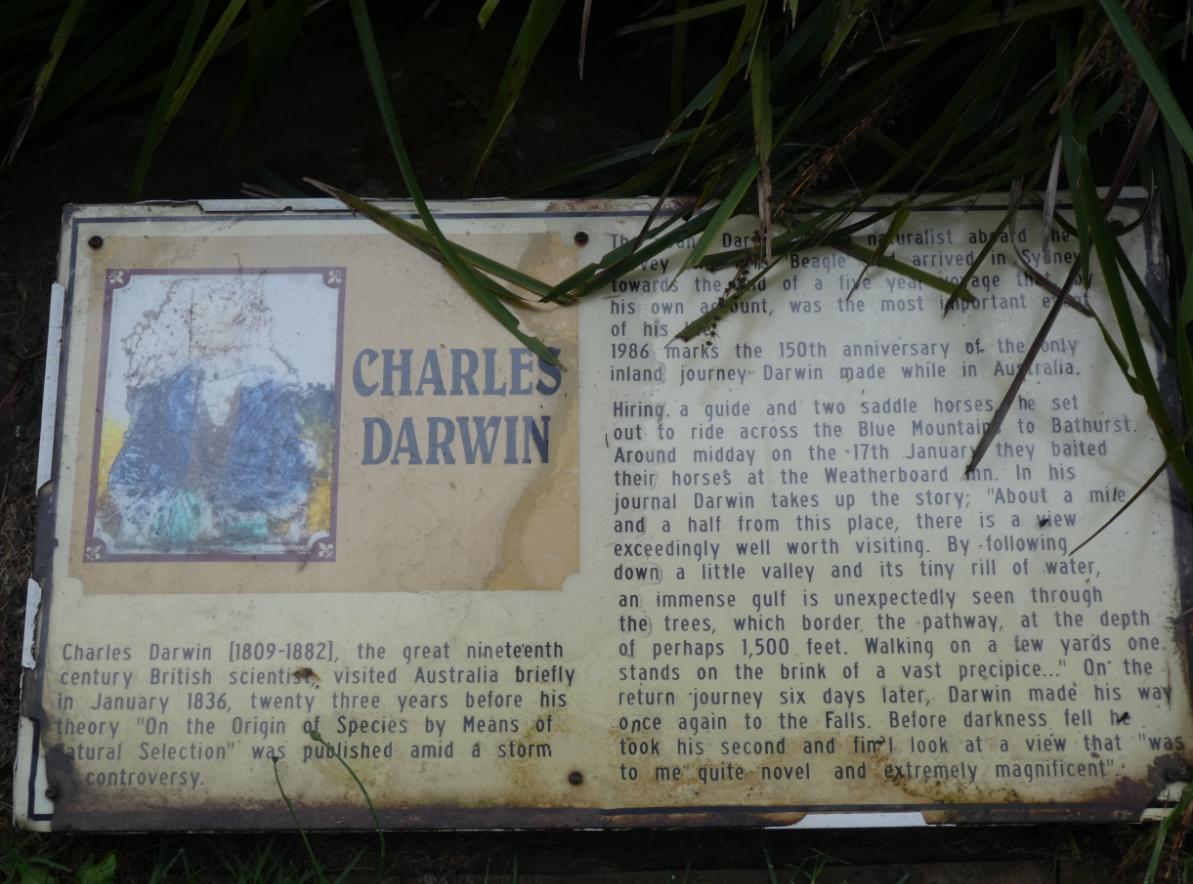
We point out that the first half section or so of this Segment 1 is the ‘Charles Darwin Walk‘ trail section eponymously dating back to early colonial pre-Australia from 1836).
Old signage along the Charles Darwin Walk before the Blue Mountains Council’s 2024 upgrade. We note that Council leftist politics (its colonial cancel culture) has destroyed it and provided no further notice of such Australian heritage. [Photo by Steven Ridd, Thursday 31st December 2020]
This trail ‘rails’ and crisscrosses through the habitat riparian zone of the Jamison Creek very gradually downstream with almost no noticeable grade, rather follows through a bushy level creek gully.
The foot track starts from the Great Western Highway (under which it is sadly a drain culvert) and then heads southward through Wilson Park then along the creek’s shallow gully toward the Jamison Valley escarpment clifftop for almost 3 km.
However, this creek has a poor abused history spanning over nearly two centuries, having suffered the following exploitation and damage:
- Bush-bashing exploration (1836)
- Colonial railway damming upstream to create Wentworth Falls Lake (1878) – water supply for new steam trains
- Repeated flooding damage from the spillway overflowing
- Sewage network trenching works (hikers pass under a massive sewage pipe)
- Pesticide pollution of Bifenthrin (July 2012) by a pest control contractor to The Grand View Hotel adjacent, which via the hotel’s stormwater drainpipe directly into the creek, exterminated the creek’s aquatic invertebrate wildlife and all downstream into World Heritage Kedumba River.
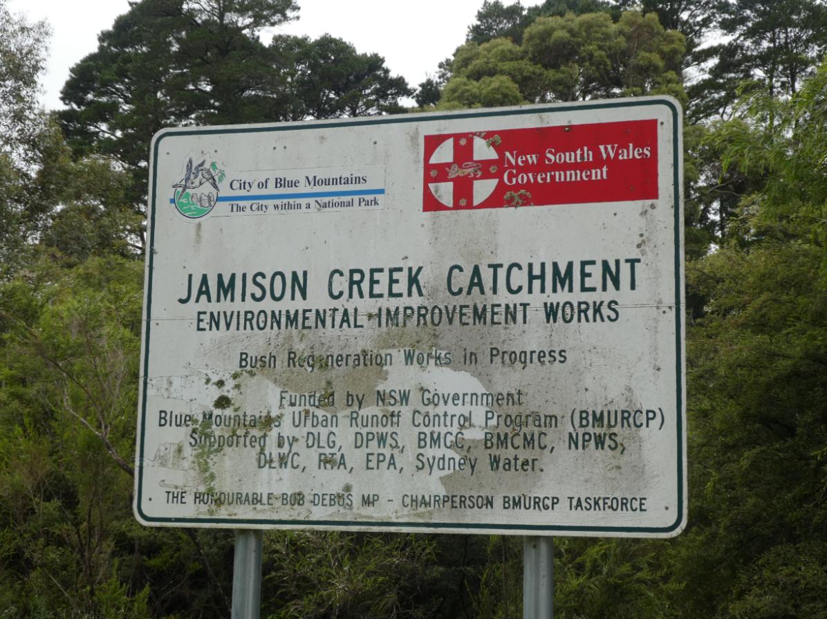
So much for the Blue Mountains Urban Runoff Control Programme (1996-2003) to rehabilitate the abused and long neglected Jamison Creek Catchment. The state of the sign and its recent removal sends what message? [Photo by Steven Ridd, Tuesday 31st December 2020].
This author happens to be old enough (61 at the time of writing) to also recall the traditional bushwalking fraternity hiking the ‘Charles Darwin Walk‘ and other local tracks, many of whom arriving early in the morning from Sydney.
Afterwards, before heading back to Sydney, they had grown a tradition of gathering for afternoon tea with cake at a then well-known café on the corner of Station Street and the Great Western Highway, Wentworth Falls. Yes, for those of my vintage and older, it was called The Elm Tree Tea Room, named after the heritage Elm Tree across Station Street in Coronation Park, just by the railway station at Wentworth Falls (colloquially ‘Wenty’).
The railway station happens to be adjacent to the current Fed café. Wenty is an old village; think origins from 1826.
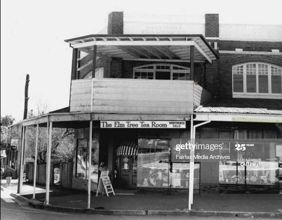
Many old timer ‘bushwalkers’, particularly having trained up from Sydney (2 hours each way), will recall this afternoon tea classic following a good day’s hiking before then returning by train back to Sydney. The combination experience became a tradition amongst the Sydney-based bushwalking clubs fraternity.
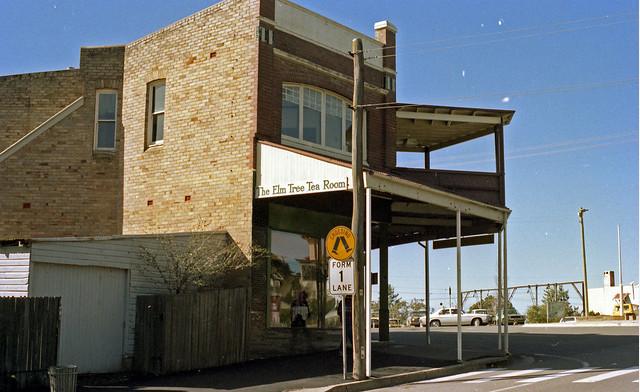
A side view of same looking from across the Great Western Highway at Saville Motors?
A direct walk over this pedestrian crossing leads towards the traditional beginning of Charles Darwin Walk foot track connection. It commenced about 100 metres or so then from along the footpath westward passed historic Saville Motors situated on the other side of the highway. See map below.
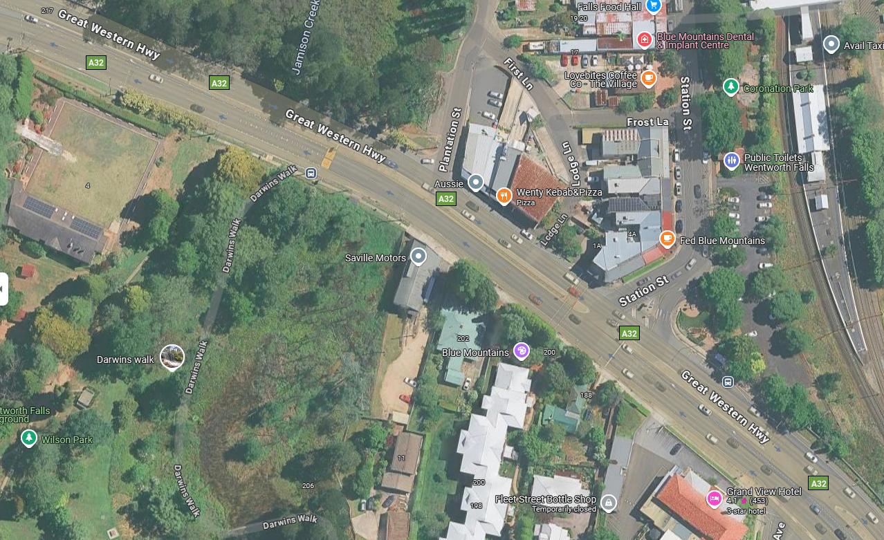
Satellite photo of the map between Wentworth Railway Station, Fed café and the start of ‘Charles Darwin Walk’ track. [Source: Google Maps, 2025]
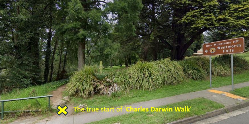
The location of the original starting point of Charles Darwin Walk unobtrusively aside the south side of Great Western Highway at Wentworth Falls. It is situated about 150 metres north of Council’s more recent elaborate gateway entrance which is constructed next to the tennis courts.
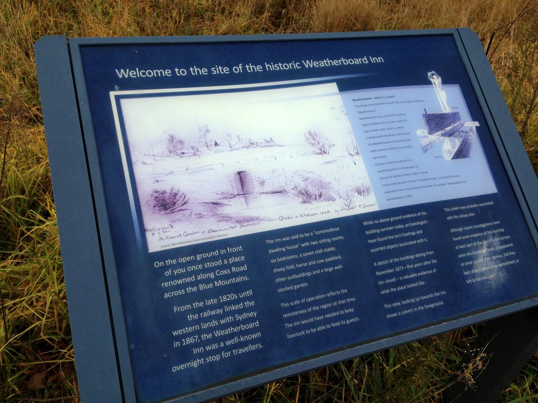
The original ‘walk’ commenced from Weatherboard Inn in 1836:
I do add a historical correction to this starting point, which dates historically accurately.
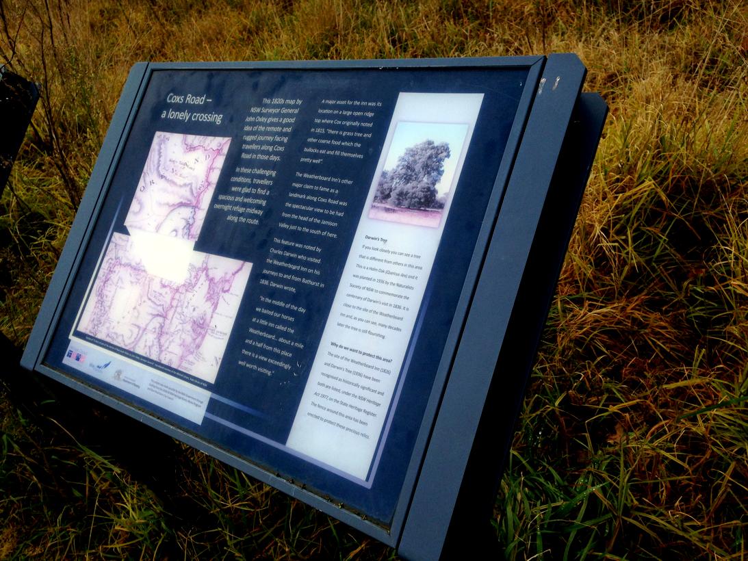
The namesake of ‘Charles Darwin Walk‘ is the famous English naturalist, geologist, and biologist, Charles Robert Darwin [1809-1882] who stayed at the original first Weatherboard Inn (the site of Wentworth Falls village) and back in 1836.
Whilst exploring this still unexplored region (by colonialists) on horseback from Sydney Cove to Bathurst, on foot he walked from the Inn to the Jamison Escarpment and back following Jamison Creek. Hence the eponymous ‘Charles Darwin Walk‘ hiking track.
The original starting point of his ‘walk’ (more likely a bushbashing and wading hike) along the original pristine creek was from the Inn downstream following this same creek until he reached the clifftop atop the impassable chasm of the Jamison Valley below.
The location of what was ‘Weatherboard Inn’ at the time is now and has for a century of so been abandoned to be a derelict remnants of only the inns foundations. The ruin site is located in a small fenced off bush reserve off Adele Avenue as it turns left and becomes Matcham Avenue, adjacent and east of the grass running oval of Pitt Park.
On that bend on the right hand side, there is a green heritage sign by the roadside on a telegraph pole indicating a grassy walk to the ruin site.
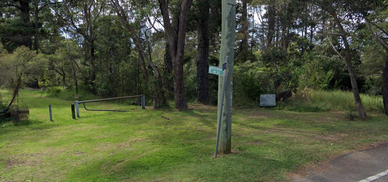
The green sign reads ‘Weatherboard Inn Site’. [SOURCE: Google Maps, Street View, Image Capture: Feb 2025]
After parking in the nearby car park and then taking about a 200 metre stroll down this grassy pathway, one reaches the site which features two heritage interpretive signs that help explain the history of the Weatherboard Inn.
As for the ruin site, there is little to see nor understand, since almost nothing remains of the inn. But the interpretative information boards is what matters to learn about Blue Mountains colonial heritage.
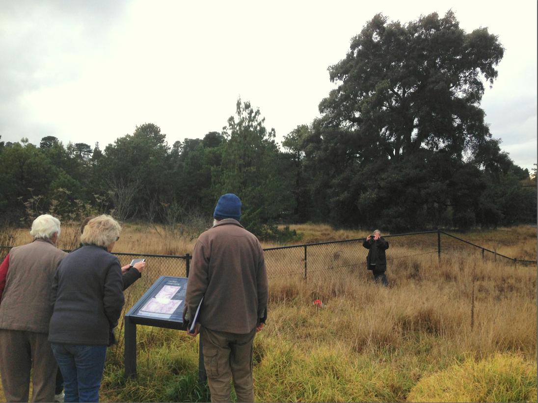
On a short tour shown in front of the ruin site of the Weatherboard Inn (Wentworth Falls) in the background. In the foreground, leading this historical tour is Blue Mountains local historian and author John Low, OAM (wearing a beanie) and fellow members of the ‘Bee Hive Group’ of Hoskin’s Memorial Uniting Church. [Photo by Steven Ridd, 2018]
These are the two interpretive information boards introducing the Weatherboard Inn ruin site:
[Photo by Steven Ridd, 2018]
[Photo by Steven Ridd, 2018]
Such is the traditional beginning of ‘Charles Darwin Walk‘, which is Nature Trail’s preferred alternative starting (or finishing point) for this trail segment. It is different to the 2024 version of the current recommended ‘Grand Cliff Top Walk‘.
The 1980’s original ‘Grand Cliff Top Walk’ concept:
Our research has revealed that the original ‘Grand Cliff Top Walk’ concept was to ultimately link the Weatherboard Inn (Wentworth Falls) to the Explorers’ Marked Tree (1813) at Pulpit Hill located about 4 km west of Scenic World in Katoomba. The trail was intended to eventually connect up with the historic ‘Six Foot Track‘ thereafter by constructing additional cliff top hiking tracks. Read below.
Extract of the original Grand Cliff Top Walk concept from the 1980s. [Source: ‘How to See The Blue Mountains’, a printed book, re-published in 1989 (Wentworth Falls), 2nd Ed., by Jim Smith Ph.D, page 138-139].
So the 2024 ‘Grand Cliff Top Walk‘ trail by Blue Mountains Council is but hybrid of the planned originally intended trail as part of celebrating the Explorers Crossing of the Blue Mountains bicentenary in 2013.
The following map sourced from Google Maps shows what is a current trail route extension from Scenic World to the Explorers Marks Tree, being the official starting point for the heritage Six Foot Track.
The trail continues for the most part following the cliff top of the Jamison Escarpment. It rails Cliff Drive from Scenic World to Boar’s Head and Cahill’s Lookout, but then currently the trail is forced to return to Narrowneck Road for a stretch to Stuarts Road and then travel through Bonnie Doone Glen.*
As an aside:
This author Steven John Ridd correctly spells “Doone” with an “e” because this is the original English spelling. It is the spelling of the classic romantic novel ‘Lorna Doone‘ of 1869 by R. D. Blackmore which is set in Exmoor in north Devon, to which this author has fond connections and ancestral heritage. “Doone” is an old Scottish word for hill.]
Unfortunately Google Maps fails to show Bonnie Doone Track properly from the western dead end of Stuarts Road.
Instead in reality, the Bonnie Doone Track starts from the dead end of Stuarts Road, continues along the clifftop of the Western Escarpment (overlooking Nellies Glen down to the west), passes by the short side track of Therabulat Lookout, then descends into the glen across a small unnamed watercourse and then ascends out the other side of the glen up to a junction with a vehicular track.
The following map is a little clearer about Bonnie Doone Track section. An alternative exit route out of Boone Doone is to follow a northerly track via the old disused quarry site of what was Katoomba Brick and Tile works to foot track which leads up to Pulpit Hill and the Explorers Marked Tree.
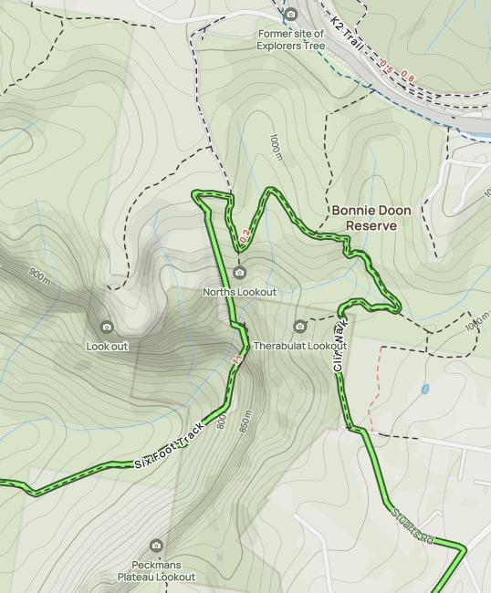
Bonnie Doone Track with track options northward to the Explorers Marked Tree. [Source: Alltrails website, ^https://www.alltrails.com/trail/australia/new-south-wales/nellies-glen-and-devils-hole]
Council has relocated the starting point of Charles Darwin Walk to being 400 metres south of the Weatherboard Inn ruin site (250m south to the highway, then another 150 metres south of the highway beside the tennis courts to allow for Council’s Wilson Park to be created. This has become the subsequent start of Charles Darwin Walk, since renamed by Council to Darwin’s Walk. Perhaps in time renamed again to just its 2024 ‘Grand Cliff Top Walk’ (yet along the dammed creek), so cancelling history completely.
Nature Trail’s proposed alternative interpretative guided tour is to respect the original history and either start or finish this Segment 1 as follows:
- Morning tour only
- No breakfast stop – (for guests to have completed before our hiking tour)
- Transfers/shuffles (including from/to Wentworth Falls Railway Station <> Conservation Hut)
- Interpretative commentary at both sites
- Parking at Pitt Park/else near Fletcher Street
- Transfer Shuffle
- Pre-booked lunch options as one guest group in Wentworth Falls village /Conservation Hut (allow 90 minutes)
- Local Blue Mountains transfers
In 2020, the track was closed due to another flooding event caused mainly from the upstream Wentworth Falls Lake spillway overflowing from a periodic La Niña torrential rainfall events from February 2020.
Council’s relocated start ‘Charles Darwin Walk’ to make way for Wilson Park to the highway. Here readers can see that Blue Mountains Council had already started abbreviating ‘Charles Darwin Walk’ to ‘Darwin’s Walk’ on its information sign (see right). [Photo by Steven Ridd Saturday 6th November 2021]
The ‘Grand Cliff Top Walk’ trail is newly well signposted in order to adhere to this particular amalgamated trail.
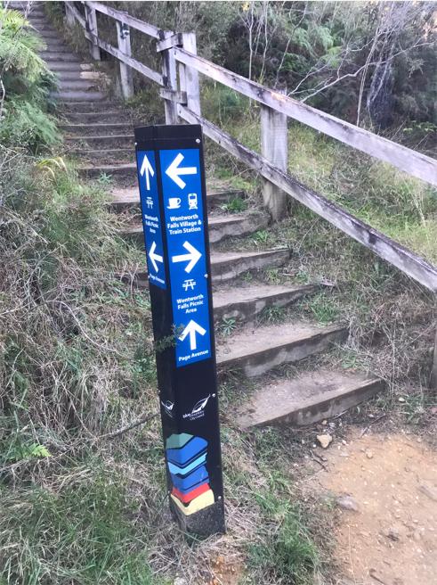
This new signage is a much welcomed improvement to help clearly guide unfamiliar hikers. On this particular track sign, we appreciate local Council’s use of its own recognisable logo at the base. But the old staircase in treated pine and dilapidated fencing remains.
Our Photographic Journey along the Charles Darwin Walk section:
Wentworth Falls Lookout to Conservation Hut section:
Please note that there is a network of other connecting tracks along the way to be aware of, but it this new Grand Cliff Top Walk trail is now mostly signposted.
The complex network of tracks along the Jamison Escarpment of (south) Wentworth Falls. [Source: Google Maps 2025]
However, this recently renamed trail roughshods over heritage track namings. It also remains still unfinished despite being officially launched by government back on 25th March 2024.
Frankly, we consider it to be a wasteful scandal in more ways that one.
Governmental ‘Grand Cliff Top Walk‘ of which few hikers will ever undertake as promoted be done in just 2-days, rather mostly in sustainable half-day segments. This mega-trail concept by Blue Mountains Council jointly with the NPWS (Parks Service) has flaws galore!
Let’s begin with the segment of Charles Darwin Walk at Wentworth Falls, being the recommended official start of this trail concept.
(1) This hiking track ‘concept’ remains ongoing incomplete over a year following its governmental official opening (at time of writing in July 2025);
(2) Many track sections remain of the old treated-pine or warn down sandstone step construction – neglected and dangerous to slippage and tripping injuries;
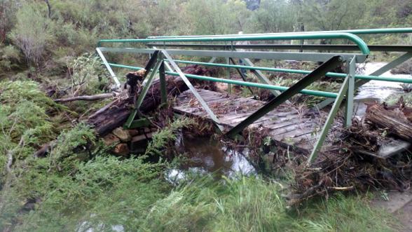
(3) Old timber boardwalk sections crossing over Jamison Creek continue to be exposed to overnight frost during winter of clear skies, so making them slippery and creating a hazard for hikers of slipping into the creek.
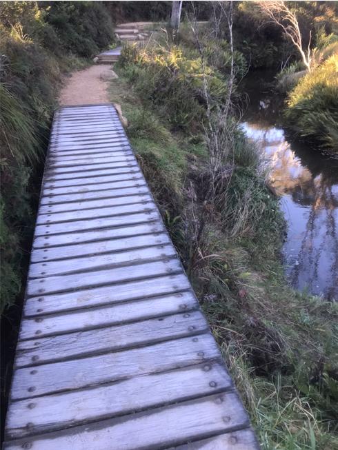
It’s 8am along the Charles Darwin Walk track segment of Grand Cliff Top Walk trail. Here the morning sun has still not risen over the hill to the east. So a number of timber boardwalks like this one remain frosted over and slippery underfoot. [Photo by Steven Ridd Wednesday 18th June 2025].
- The governmental plagiarism by both Council and Parks Service (NPWS) copying Nature Trail’s established copyright business logo as their own track wayfinding signage (see image below)
- Blue Mountains {city} Council has attempted to rename this classic track, now twice:
(A) From originally ‘Charles Darwin Walk‘ to ‘Darwin’s Walk‘
(B) Then from ‘Darwin’s Walk‘ to killing off Darwin by re-branding it as a ‘Grand Cliff Top Walk’, so culturally cancelling Charles Darwin’s historical legacy eponym. So Generation Alpha: “…so who was Darwin?“
Blue Mountains Council has long sought to change the traditional starting location of historic ‘Charles Darwin Walk’. Lately it has had taxpayer-funded contractors install yet another copy-cat sandstone ‘welcome wall’ reinforced relocated entrance to this classic track. Then Council had the temerity to nick and use Nature Trail’s established business logo and claim it as aboriginality. Cancel culture or just nicked culture?
As an aside:
And as we have observed over the years, of late, Council’s habitual creation of sandstone walls at upgraded track heads over time. But they fade from spanking golden to dull grey from in ultraviolet sunlight during successive summers. Then the unprotected sandstone also gets wet by regular rains, which naturally attracts mould to cover the sandstone surface so blackening it.
Black mould on sandstone is a common issue due to sandstone’s porous nature and susceptibility to moisture. Council doesn’t bother sealing the sandstone from moisture at the time of construction. The project funding is typically from the NSW Government, so it can’t be blamed on cost saving excuses; more so ignorance and Council’s short term lack of care factor!
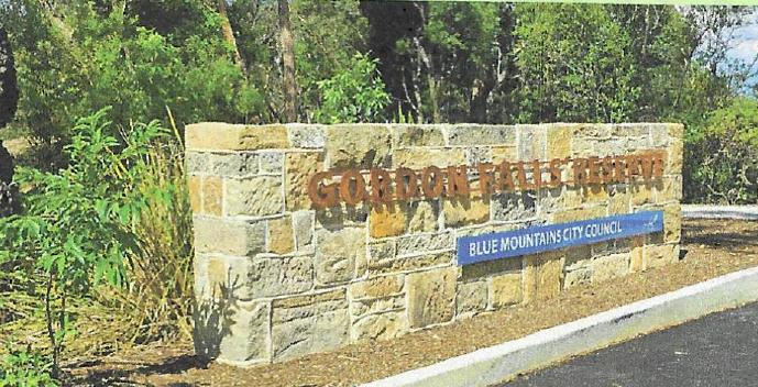
This Council has habitually done these welcome walls at Echo Point (1999 and 2020), in The Gully (2013) and most recently at Gordon Falls (2025). These fancy sandstone block walls look great for the first few years or so, but then like neglected gravestones years later…
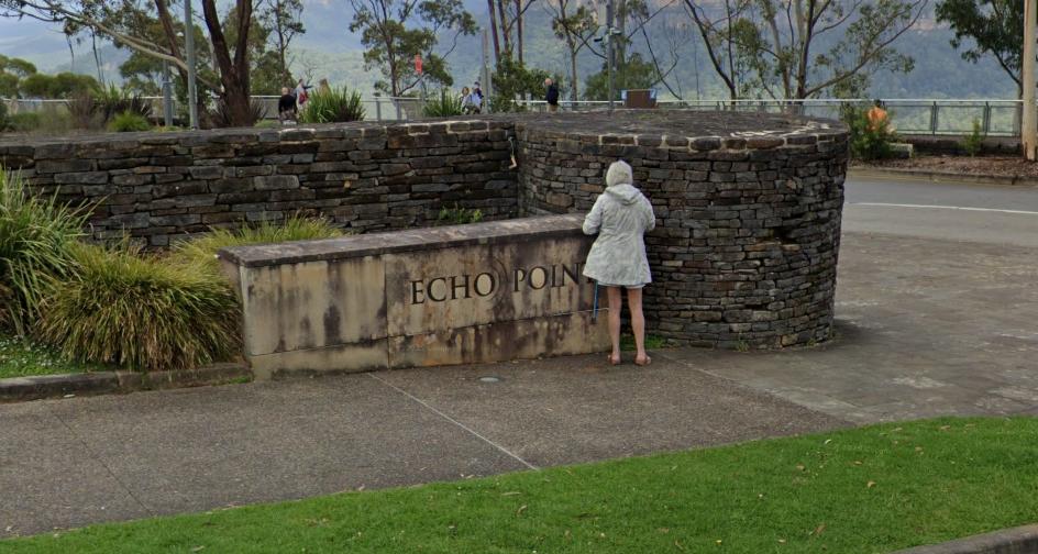
Echo Point sandstone grotty ‘welcome wall’ built circa 1999 as part of Council’s “revitalisation project”. The glossy revitalisation has definitely been abandoned. [Source: Google Maps, Street View March 2025].
Notably, in the above image, the more traditional and durable use of the harder and more dense ‘ironstone’ (of local legendary garden landscape designer Paul Sorensen style) for the high wall, does not have the same porous characteristics as does unprotected sandstone. The ironstone has mostly retained its colour, but likely similarly unprotected from water ingress and so therefore black mould.
Council’s Gully sandstone grotty ‘welcome wall’ in Katoomba from 2013. This local author (who lives nearby and regularly walks around The Gully) noted within a few years the various unprotected sandstone walls of Council increasingly allowed to be contaminated with black mould. And above is the result. [Photo by Steven Ridd 12th August 2022].
Is this part of Blue Mountains sustainable strategic plan? Lookout Graveyard sites?
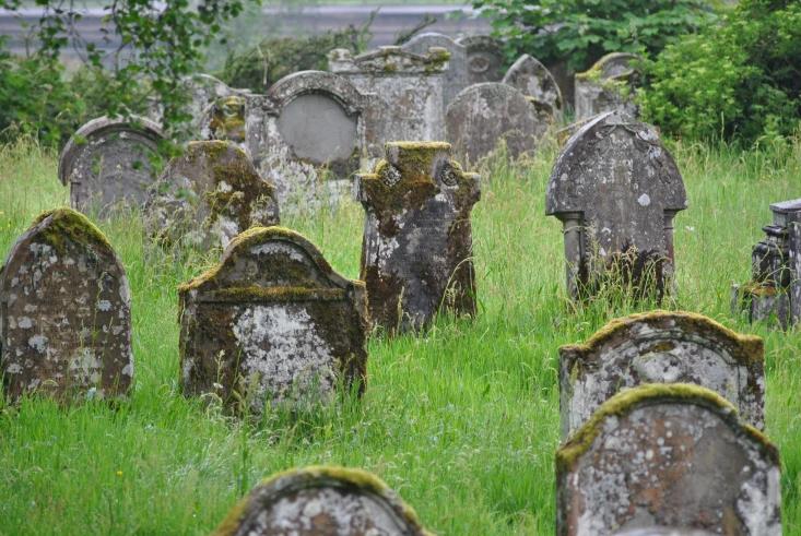
Council’s habitual contracted use of sandstone wall signage is flawed. Over decades the bright golden hewn sandstone will cop rain ingress and black mould growth and coverage to resemble old graveyards and the likes of Cambodian Ankor Wat temple.
Here are two more recent ignorant wasteful examples of Council’s ‘Sandstone Dreaming’…
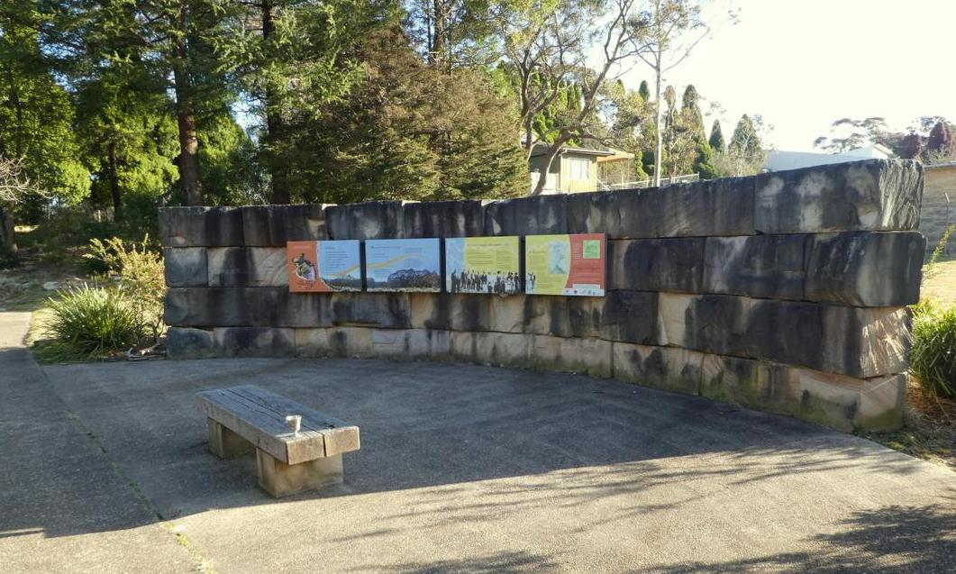
Council’s recent sandstone ‘yarning circle’ wall in The Gully – no community consultation. It just appeared one day by the dam. Good for piles, not veins – no wonder I’ve never seen anyone using it. Give it a few years of rain and it will be similarly blackened. [Photo by Steven Ridd, Wednesday 3rd August 2022]
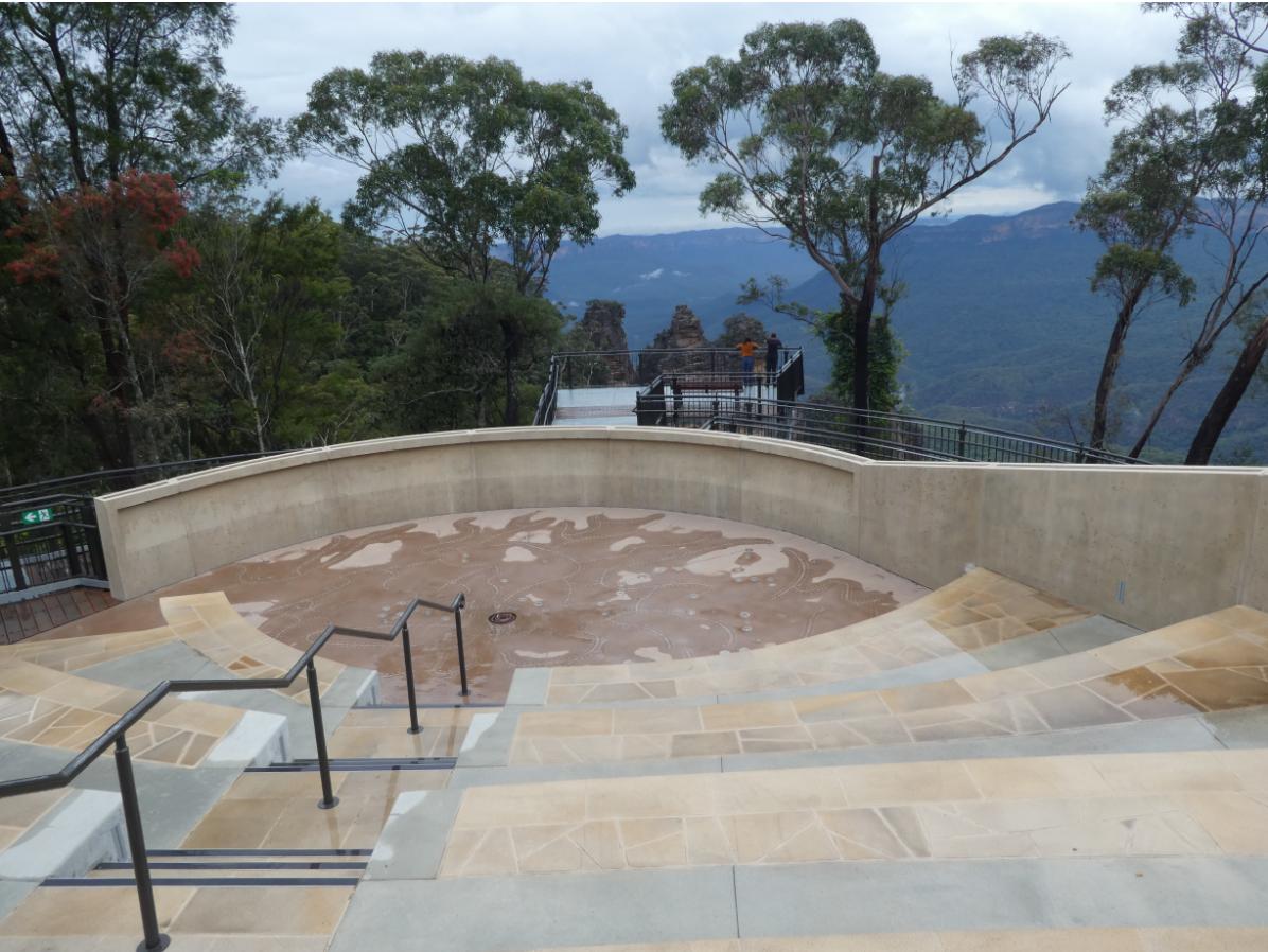
Council’s Echo Point 2019 extravagant $6 million sandstone ‘Haemorrhoid Gathering Place’ being a joint 50:50 funding venture between the Australian Government and Blue Mountains ratepayers (Council). To justify the views, Council killed several native Eucalypts (see gap). So much for UNESCO listing because of Eucalypts. This white elephant is always empty as well. It too will be covered in black mould in a few years. [Photo by Steven Ridd, 26th November 2020].
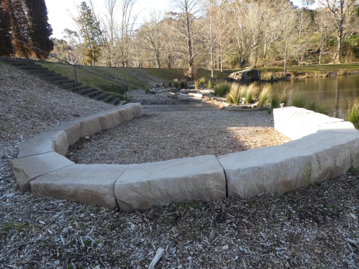
So at Gordon Falls Picnic Reserve, situated in a different segment of this 2024 ‘Grand Cliff Top Walk’ trail, here’s yet another one of Council’s ‘pre-mouldy’ welcome walls installed at its recently upgraded Gordon Falls Picnic Reserve.
Clearly it would seem given this pattern persisting, some influential senior manager at Blue Mountains Council holds sway on lookout redesign, having an obvious penchant for big sandstone welcome walls. It’s like a static welcome to country equivalent to fancy new lookouts, and with Council’s stamp in bold to passively state: ‘aren’t we great at Council.’
The above image was clearly taken very shortly after this new welcome wall was constructed, probably by the stonemason as the mortar dried. It is bright and brimming.
Yet Council did not fund it.
“The Gordon Falls Reserve upgrade is part of the overall development of the Grand Cliff Top Walk, funded by the Australian and NSW Governments Bushfire Local Economic Recovery Fund. The upgrade is also funded by $2.4 million from the NSW Government’s Western Sydney Infrastructure Grants Program, in association with Blue Mountains City Council.”
[^Source]
But Council Mayor Mark Greenhill lavishes the credit. The upgrade project commenced around June 2020 and was officially declared open by government on 29th April 2025.
Yet, comparing the previous photo, in the following official opening photo the wall already starts to show signs of black mould contamination. We have received lots of heavy La Nina east Coast Low rains of late. The porous sandstone wall would be saturated, then the warm weather has been an ideal ‘petri-dish’ conditions to encourage black mould spore growth.
Current image of The Conservation Hut below…
Conservation Hut, Fletcher Street, 2025.
Previously…
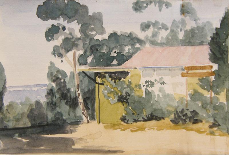
This is a painting of the original Hut by Lloyd Jones.
References and Further Reading:
[DISCLAIMER: Nature Trail researches its source information as part of this article, which we privately record for our own personal referencing. If any of the references below ever become ‘dead links’, that is, deleted from public access online; we always have retained a full documented copy of that original reference document and every other listed in this section below. This ensures our article stands up truthfully to having relied upon the factual record made public online which we have sourced at the time. So, if ever challenged later in law, we can reproduce that and any document in toto as evidence.]
[1] ‘Grand Cliff Top Walk unveiled in Blue Mountains‘, 2024-03-25, Blue Mountains Gazette (newspaper), ^https://www.bluemountainsgazette.com.au/story/8566633/grand-cliff-top-walk-opens-connecting-wentworth-falls-to-katoomba/
[2] ‘Grand Cliff Top Walk – Blue Mountains‘ brochure, National Parks and Wildlife Service of NSW, (undated), DCCEEW, 2 pages
Loading...
[3] ‘NPWS (Parks Service) plagiarises Nature Trail’s copyright logo‘, 2025-05-30, Steven Ridd, Tour Director, Nature Trail, Mountains Drums blog, ^https://naturetrail.com.au/blog-post/npws-parks-service-plagiarises-nature-trails-copyright-logo/
[4] ‘Blue Mountains Council (BMCC) plagiarises our business logo and then falsely claims it to be Gundungurra?‘, 2025-07-14, by Steven Ridd, Tour Director, Nature Trail, Mountains Drums blog,^https://naturetrail.com.au/blog-post/blue-mountains-council-bmcc-plagiarises-our-business-logo-and-then-falsely-claims-it-to-be-gundungurra/
[5] ‘Blue Mountains ‘Grand Cliff Top Walk’ – Misleading Flyer & Press Release‘, 2025-07-05, by Steven Ridd, Tour Director Nature Trail, ^https://naturetrail.com.au/blue-mountains-grand-cliff-top-walk-misleading-flyer-press-release/
[6] ‘Blue Mountains ‘Grand Cliff Top Walk’ – a misleading promotional article‘, 2025-07-05, by Steven Ridd, Tour Director Nature Trail, ^https://naturetrail.com.au/blue-mountains-grand-cliff-top-walk-a-misleading-promotional-article/
[7] ‘MT-GCT Grand Cliff Top Walk Trek‘, 2025-07-05, by Steven Ridd, Tour Director, Nature Trail, ^https://naturetrail.com.au/mt-gct-grand-cliff-top-walk-trek/
[6] ‘Blue Mountains ‘Grand Cliff Top Walk’ Our Critique – SEGMENT 1: Wentworth Falls Railway Station to Conservation Hut‘, 2025-07-05, by Steven Ridd, Tour Director, Nature Trail, ^https://naturetrail.com.au/blue-mountains-grand-cliff-top-walk-our-critique-segment-1-wentworth-falls-railway-station-to-conservation-hut/
[7] ‘Blue Mountains ‘Grand Cliff Top Walk’ Our Critique – SEGMENT 2: Conservation Hut to Fairmont Resort‘, 2025-07-05, by Steven Ridd, Tour Director, Nature Trail, ^https://naturetrail.com.au/blue-mountains-grand-cliff-top-walk-our-critique-segment-2-conservation-hut-to-fairmont-resort/
[8] ‘Blue Mountains ‘Grand Cliff Top Walk’ Our Critique – SEGMENT 3: Fairmont Resort to Gordon Falls Picnic Reserve‘, 2025-07-05, by Steven Ridd, Tour Director, Nature Trail, ^https://naturetrail.com.au/blue-mountains-grand-cliff-top-walk-our-critique-segment-3-fairmont-resort-to-gordon-falls-picnic-reserve/
[9] ‘Blue Mountains ‘Grand Cliff Top Walk’ Our Critique – SEGMENT 4: Gordon Falls Picnic Reserve to Leura Cascades Picnic Reserve‘, 2025-07-05, by Steven Ridd, Tour Director, Nature Trail, ^https://naturetrail.com.au/blue-mountains-grand-cliff-top-walk-our-critique-segment-4-gordon-falls-picnic-reserve-to-leura-cascades-picnic-reserve/
[10] ‘Blue Mountains ‘Grand Cliff Top Walk’ Our Critique – SEGMENT 5: Leura Cascades Picnic Reserve to Echo Point Lookout‘, 2025-07-05, by Steven Ridd, Tour Director, Nature Trail, ^https://naturetrail.com.au/blue-mountains-grand-cliff-top-walk-our-critique-segment-5-leura-cascades-picnic-reserve-to-echo-point-lookout/
[11] ‘Blue Mountains ‘Grand Cliff Top Walk’ Our Critique – SEGMENT 6: Echo Point Lookout to Reid’s Plateau‘, 2025-07-05, by Steven Ridd, Tour Director, Nature Trail, ^https://naturetrail.com.au/blue-mountains-grand-cliff-top-walk-our-critique-segment-6-echo-point-lookout-to-reids-plateau/
[12] ‘Blue Mountains ‘Grand Cliff Top Walk’ Our Critique – SEGMENT 7: Reid’s Plateau to Explorers Marked Tree‘, 2025-07-05, by Steven Ridd, Tour Director, Nature Trail, ^https://naturetrail.com.au/blue-mountains-grand-cliff-top-walk-our-critique-segment-7-reids-plateau-to-explorers-marked-tree/
[13] ‘Blue Mountains Best Bushwalks‘, 2016, 3rd Ed., by Veechi Stuart, printed paperback book, published by Woodslane Press Pty Ltd, Warriewood, Australia, ISBN 978 192540 32 9 9, Dewey No. 919.440504
[14] ‘How To See The Blue Mountains‘, 1989, 2nd Ed., by Jim Smith Ph.D, printed paperback book, published by Second Back Row Press Pty Ltd, Katoomba, Australia, ISBN 09093255 2 9
[15] ‘Upper Blue Mountains Geographical Encyclopaedia‘, 2001, 2nd. Ed., by Brian Fox, published by Brian Fox, Bathurst, Australia. ISBN 0 9578737 1 9
This webpage updated: 2025-07-24.