Blue Mountains ‘Grand Cliff Top Walk’ Our Critique – SEGMENT 7: Katoomba Falls to Megalong Head
(A) Brief Background
Let the truth be known, the ORIGINAL ‘Grand Cliff Top Walk‘ as proposed in the 1980s was to construct a hiking track to extend from the original Weatherboard Hut (from 1814) site all the way to the Explorers’ Marked Tree (from 1813) – to create an epic 30+ km amalgamation mega trail concept to link up old and new hiking tracks dating back to times of early colonial exploration, The Great Depression and to provide a timeless education legacy about early Australia for future generations.
It was conceived by Blue Mountains Council engineers for the then proposed bicentennial celebration of the first colonial crossing of the Blue Mountains between 11th and 28th May 1813 – just 18 days.
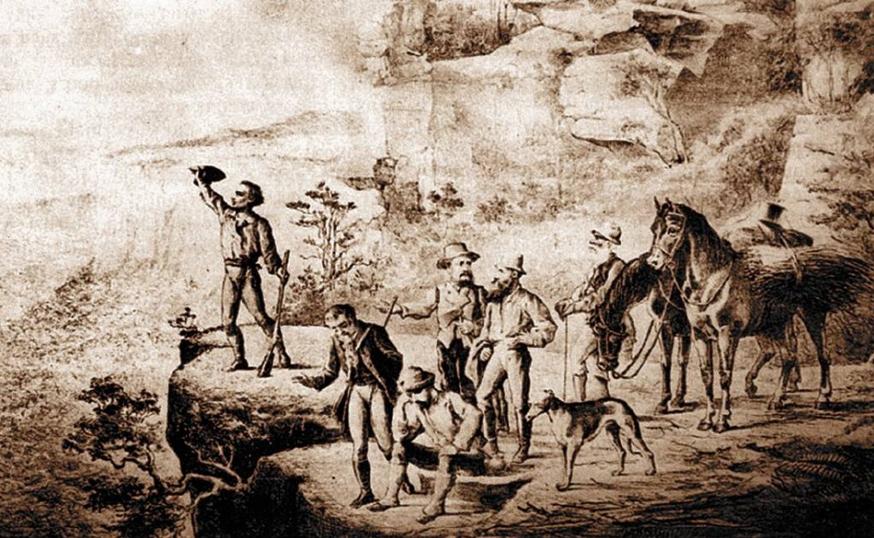
Earliest pictorial representation of the first successful colonial crossing of the Blue Mountains at Mount York in wonder of the hope of desperately needed pasture westward beyond to save the fledgling Sydney Cove colony. This being a key historical event in Australia’s history. [Image Source: The Sydney Mail, 25 December 1880].
“The Birth of Wentworth Falls Village
In 1813 Gregory Blaxland, William Lawson and William Wentworth found a way across the Blue Mountains, reaching what is now Wentworth Falls on Sunday 22nd May 1813.
The job of building a road across the mountains was awarded to William Cox, in 1814. In six months he and his convict workers – who were rewarded with their freedom – built the road 4 metres wide and 170 kms long, from Emu Plains to Bathurst.
Wentworth Falls was originally known as Weatherboard because of the weatherboard construction of the first building in the area. This continued until 1879 when the name became Wentworth Falls due to other towns already having the name of Wentworth.
Cox’s Weatherboard Hut
On 8th October 1814, The Weatherboard Hut was completed at the site on the eastern side of the Jamison Creek, approximately at the rail embankment below the road bridge at Wentworth Falls. It was used to house the men and tools as they pushed the road forward (Blaxland Road). The straight stretch that borders the BMHS was constructed by Lt Thomas Hobby, and called by Cox, Hobby’s Reach.
The hut was in use as a military post, by soldiers stationed there to check passes allowing travellers to use the road. It ceased to be used in approximately 1832.
The Weatherboard Inn
The Weatherboard Inn raised the standard of accommodation in 1827.
The site is on the southern border of Pitt Park, on the western side of Jamison Creek. It was built in 1827 when licenses were not yet issued. The first license was issued in 1833 and it was named The Bathurst Traveller.
On 17th January 1836, after tethering his horse at The Weatherboard Inn, Charles Darwin walked to the Wentworth Falls along the wooded valley (now known as Darwin’s Walk). On 23rd January, on his return from Bathurst en-route to Sydney, he stayed overnight at The Weatherboard Hut.
It was not named ‘The Weatherboard Inn’ until 1847 and was in operation until 1867 when the railway arrived, causing the closure of most of the inns.”
[Source: © 2009 Wentworth Falls Chamber of Commerce and Community Inc. ^ https://www.wentworthfalls.org.au/history-of-wentworth-falls/]
But by 2021, communist ‘cancel culture’ politics by a Labor/Greens controlled Council unravelled this historical concept. They schemed the iconic remnants of the Explorers Marked Tree be deemed “unsafe”, and so on Saturday 20th February 2021, Labor Mayor Mark Greenhill had the decades-long neglected iconic symbol destroyed, disappeared (if not incinerated) as a contemptuous statement of cancel culture against Australia’s colonial heritage.
So, what to do to celebrate the ORIGINAL ‘Grand Cliff Top Walk‘ and the historical crossing legacy? Start or finish at the now two sites of cancelled heritage culture? For either options it would be an anticlimax to such an epic hiking trail – but from one death site to another, either directions?
Instead, Nature Trail, since curretly completing the politically correct 2024 abridged version of the ORIGINAL ‘Grand Cliff Top Walk‘, has since elected to extend the trail further. And what better place to start or finish than at Megalong Head!
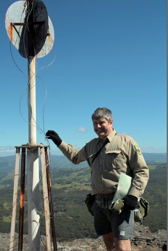
Nature Trail’s Tour Director Steven Ridd at Megalong Head trig point (the Megalong behind), whilst reconnoitring with Friends of Nature Trail back in 2012 – a tad more salt and pepper atop back then.
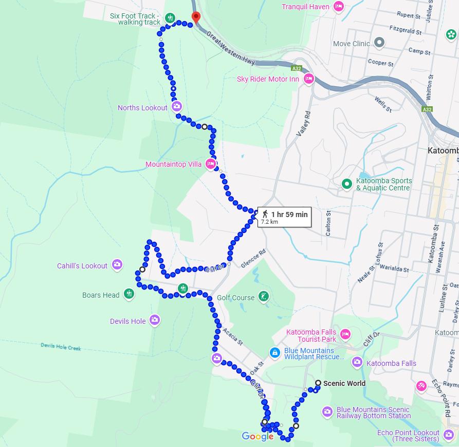
The following map sourced from Google Maps shows what is a current trail route extension from Scenic World to the Explorers’ Marks Tree, being the official starting point for the heritage Six Foot Track.
The trail continues for the most part following the cliff top of the Jamison Escarpment. It rails Cliff Drive from Scenic World to Boar’s Head and Cahill’s Lookout, but then currently the trail is forced to return to Narrowneck Road for a stretch to Stuarts Road and then a hiking track traversing Bonnie Doone glen, up to the site of the Explorers’ Marks Tree, then along the cliff top of Radiata Plateau to Megalong Head overlooking the historical Megalong below.
As an aside:
This author Steven John Ridd correctly spells “Doone” with an “e” because this is the original English spelling. It is the spelling of the classic romantic folkloric novel ‘Lorna Doone‘ published in 1869 by R. D. Blackmore which is set in Exmoor in north Devon in England, of which this author has fond connections and holds ancient ancestral heritage. ‘Doone’ happens to be an ancient Scottish word for ‘hill’ – hence the ‘highlander’ troublesome Doone family in the novel.]
Unfortunately Google Maps fails to show Bonnie Doone Track properly from the western dead end of Stuarts Road.
Instead in reality, the Bonnie Doone track starts from the western dead end of Stuarts Road, continuing along the clifftop of the Blue Mountains Western Escarpment (overlooking Nellies Glen down southwestward). The track passes by the short southern side track of Therabulat Lookout, before descending into the glen across a small unnamed watercourse and then ascending up the other side to a junction with a fire trail track.
Readers are invited to independently explore this little known hiking track.
The following map is a little clearer about Bonnie Doone Track section. An alternative exit route out of Boone Doone is to follow a northerly track via the old 1950s disused quarry site of what was Katoomba Brick and Tile works to connect to a foot track which leads up to Pulpit Hill where the Explorers Marked Tree site is situated.
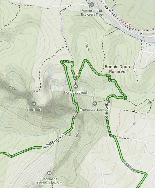
Bonnie Doone Track with track options northward to the Explorers Marked Tree. [Source: Alltrails website, ^https://www.alltrails.com/trail/australia/new-south-wales/nellies-glen-and-devils-hole]
(Content TBA)