Grand Cliff Top Walk Trail (MT-GCT)
(A) Brief Background:
On Monday 25th March 2024, the historic 1930s ‘Prince Henry Cliff Walk‘ track, after being mostly repaired, upgraded, extended in a joint tourism infrastructure project by NPWS (Parks Service) and BMCC Blue Mountains {city} Council over about four years, was officially and publicly launched.
But the red ribbon was publicly ceremoniously cut before this trail was finished.
Why? Politics? Go figure!
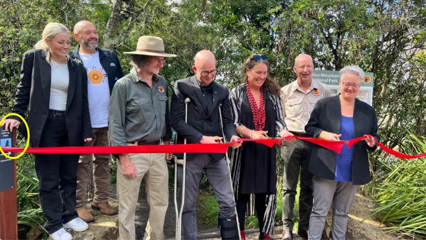
The grandiose bureaucratic triple ribbon-cutting opening of newly named ‘Grand Cliff Top Walk‘ on 25th March 2024. Yet one surmises that not one of these folk in the photo have walked the entire track. [L-R: Artist Kelsie King, Gundungurra Elder David King, Parks Service employee (unknown), Council Mayor Mark Greenhill, Blue Mountains Local Member Trish Doyle MP, Blue Mountains Director of the NPWS David Crust, NSW (mega) Minister for Climate Change, Energy, Heritage and Environment Penny Sharpe, MLC (with the scissors). [^SOURCE]
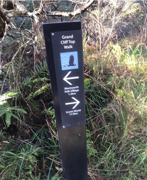
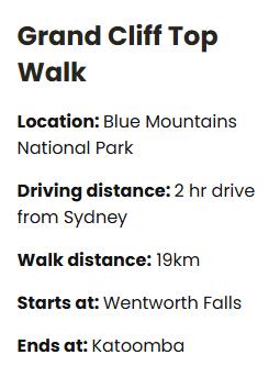
It has been jointly renamed as now the ‘Grand Cliff Top Walk‘ trail which links up with many shorter tracks extending from ‘Charles Darwin Walk‘ track in Wentworth Falls to feed into mass tourism complex ‘Scenic World’ in Katoomba. The trial is officially claimed and signposted to be 19.7 km in length and officially recommended hikeable in just 2-days – (11 km on Day 1,then 8 km on Day 2).
However for the record, Nature Trail vehemently rejects this ridiculous schedule. We explain this in more detail below in this article’s ‘Critique’ Part (D).
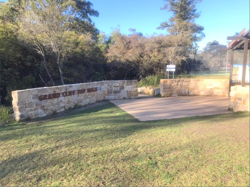
This is the official starting location of the 2024 Grand Cliff Top Walk at Wilson Park by the tennis courts in Wentworth Falls. [Photo by author Wednesday mid-morning 18th June 2025].
(B) This Trail Introduction:
The recently named ‘Grand Cliff Top Walk‘ is a trail that is officially claimed to be 19.7 km in length by foot.
It is an amalgamation of many hiking tracks, many historic, and extends between Wentworth Falls to Katoomba (either direction) following in many sections through the plateaued bushland atop the Jamison Escarpment.
However, this trail is not just a series of interconnecting hiking tracks, but also requires en route walking over a kilometre along a busy tourist road (no footpaths), and many sections remain closed as we write, and the first ‘half’ of the trail is far from any actual cliff top.
In our view, the ‘Grand Cliff Top Walk‘ naming is a misnomer or what?
The following map shows a very high level (small-scale) map of this trail (shown in red) as included on the official double-sided A4 colour flyer provided by the Parks Service we obtained at its heritage centre at Blackheath.
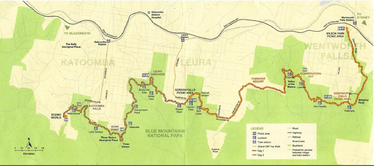
The odd scale (bottom left) shows up to 0.08 km (or 800m). Note that the green shaded area is bushland – being a mix between that custodially owned by Blue Mountains {city} Council or the Parks Service. it is not a map worth replying upon for hiking, rather just indicative. [Source: Grand Cliff Top Walk flyer, (undated), A4-sized double-sided printed colour flyer, by NPWS, The NSW Department of Climate Change, Energy, the Environment and Water (DCCEEW), NSW Government – could they have come up with a longer name?].
Blue Mountains {city} Council offers a larger version of this map in PDF format currently on its website [^Source]. We include a downloadable copy as follows. However, whereas the above map points north to the top of the map, Council’s map is upside down showing north at the bottom instead the standard top of the map. We’ve noticed similar odd mapping orientation by the Parks Service out along the track.
 Loading...
Official information about this trail may be found from either the Parks Service website [^SOURCE] or on the Blue Mountains Council website [^SOURCE].
(C) Our Reconnoitre 2025:
Nature Trail’s professional touring policy is always first to reconnoitre any proposed tracks and trails that we consider may be deliverable and worthwhile as a tour. We do this as operating policy, before deciding whether a tour route is suitable, that is:
- The track is complete
- It’s accessible (open to the public) including transport transfers
- It’s safe in all respects
- Hiking difficulty grades range under Grade 4
- The route is consistent with our style, pace and hiking duration limits
- It’s worthy of scenic value, else for a valued visitor experience
- Plus offers delivery standards consistent with our policies.
Let us first say that based upon our preliminary research and road scouting, even before our ground-truthing reconnoitring, we fail this trail on many grounds. But we maintain an open mind and have reconnoitred this end-to-end for self education and guidance to others.
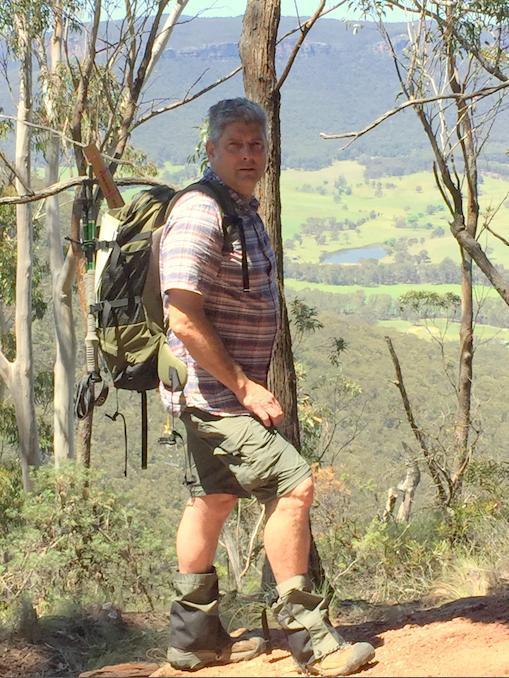
Nature Trail’s Tour Director, Steven Ridd, author of this critique article series concerning the 2024 version of the ‘Grand Cliff Top Walk’ trail.
Nature Trail, under its Risk Management policy safely undertakes ‘ground-truthing’ reconnoitring before evaluating offering a subject tour. The following photos in this article have been taken by this author Wednesday 18th June 2025, unless stated otherwise.
As an option for offering potential hiking tour options along this trail, Nature Trail is currently ‘ground-truthing’ the recent upgrades to this old trail. We are previously well familiar with the tracks along this trail over many years since the 1990s.
We have already decided to vary the trail’s offering and divided it into 7 half-day segments for our own reasons. We consider from our hiking experience of this trail that by doing so, it’s akin to restoring the tradition of its many interconnecting historic short tracks, which this new ‘mega’ trail seeks to replace, rename and culturally cancel.
Our chosen half-day numbered segments 1 to 7 are just our own discrete identifying labels, but not suggesting any order of travel. This trail is across public land so legally accessible after all, so no hiker is compelled to follow the Park’s Service (NPWS) flyer recommendation to attempt the overall nigh half marathon in a ridiculous 2 days!
Have you read the Park’s Service (NPWS) flyer for its 2024 ‘Grand Cliff Top Walk’? This is it – we avail downloadable, and thus re-printable:
Loading...
The Grand Cliff Top Walk as it is currently being promoted is a ‘concept trail’ appealing to an elite marathon fraction of Blue Mountains visitors who enjoy hiking.

Seriously, 19.7 km in just 2-days? Parks Service needs to get out more, learn the range needs of typical hiking visitors, and get more realistic with its offerings.
We have observed that this new ‘mega’ trail avoids the best vistas and experiences en route. No signage along this trail encourages any side track diversion and back so as to experience the vistas of the magnificent Jamison Valley below from the cliff top! So who decided to design and rename this series of historical hiking tracks into some ‘Grand Cliff Top Walk‘?
From our ‘ground-truthing’ reconnoitring we are beginning to presume that this fancy 2024 elongated trek ‘concept’ was done over perhaps drinks from a bureaucrat’s sheltered workshop desk. Like, they’ve never actually hiked this ‘Grand Cliff Top Walk’ end-to-end, if any section at all, so haven’t a clue of the interminable demands of its advertised half marathon.
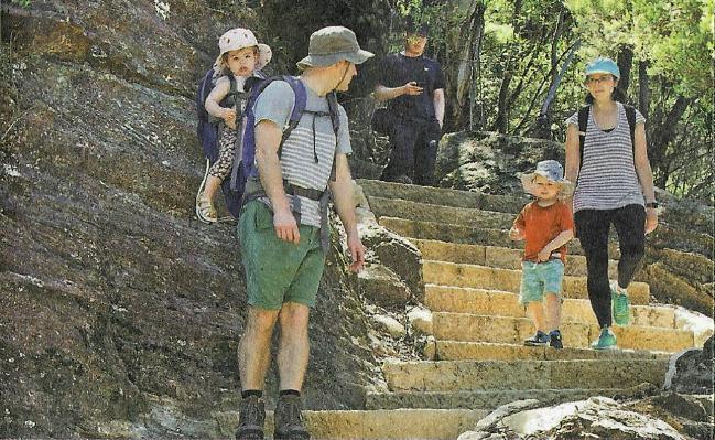
This is Parks Service’s official flyer included photo targeting toddlers to take on its 20+ kilometre half marathon hundreds of stone staircases quest in 2-days.
Nature Trail frankly calls this out as reckless and culpable negligent advertising by this government that is wilfully and wrongfully luring innocent tourists into deadly harm!
Nature Trail has done this trail previously as distinctly separate shorter tracks. We consider this amalgamated mega trail attempt in the government’s officially recommended 2-days marathon duration to be life threatening. If any hiker tries this on and gets injured or benighted, let us know, and take this to your lawyer!
If the challenge of exercising up and down a 40 floor highrise fire escape is your thing, like this Sydney Grosvenor Tower was for us during our young twenties at lunch time, then The Grand Cliff Top Walk is for you.
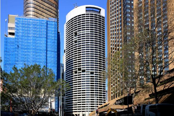
The Grosvenor Tower in downtown Sydney’s CBD.
In stark contrast, we refer readers to a very sensible and responsible local hiker’s guidebook for the Blue Mountains, written by local Blue Mountains experienced hiker, Veechi Stuart. Her book is entitled ‘Best Blue Mountains Bushwalks‘ and we have previously purchased editions #2 and #3.
Veechi in this hiking guidebook of her special Blue Mountains hike recommended as: ‘A short walk for young children‘ at page 70. We provide a copy of her guidance thus:
‘At a glance’: Toddlers on a hike with their parents can probably manage a hike of 600 metres return, not 20+ km one-way!
We offer that each and any of these segments of this ‘Grand Cliff Top Walk’ may be selected by a private tour guest group in any number of segments (even just one), in any sequence, in any direction and at random as they care to choose. Nature Trail is not beholden to the Parks Service official flyer recommendations.
Nature Trail’s Tour Director, Steven Ridd, has hiked all segments of the trail many times since the mid-1990’s and is very familiar with the many track segments of this particular concept trail and many other hiking tracks in this region. He has a lifetime of hiking experience, and is well familiar with the Blue Mountains Region and westward beyond having lived with his family in Katoomba since 2001.
Steven is currently (June-July 2025) ‘ground-truth’ reconnoitring the 2024 upgraded version of this trail but on a manageable segment by segment basis. The reconnoitre is just that, done at a slow interpretative pace with Friends of Nature Trail, documenting features en route, taking many photos and then writing up a travel journal and critique on this website for each segment. We group this under our ‘Tour Yarns‘ menu item located on the front page of our website.
This is a recent concept trail of 20+km in length, and is an amalgamation of many shorter popular hiking tracks, some being historic. In our current critique (2025) we break this back into manageable segments approximating a half-day each, for flexibility and to divide up our critique into readable articles rather than as a web-book. We offer positives and negatives for readers as hikers.
(D) Overall Critique of This Trail:
Nature Trail’s Tour Director, Steven Ridd, decided in 2025 that after a year of this recently renamed ‘Grand Cliff Top Walk’ trail after being repaired, upgraded and officially opened at a combined cost of $13 million, that it warranted a scouting perusal to consider as one of Nature Trail’s hiking tour offerings.
However, his trail scouting perusal to firstly research it online, obtaining an official flyer for this trail, driving around..well it quickly indicated that any ‘ground-truthing’ reconnoitre would not do-able in just two days.
We herein provide an overall critique of this trail below, however more detailed evaluation is provided in a series of articles as we reconnoitre, photograph and document segment by segment.
We clarify that the word ‘critique‘ means “a carefully expressed judgment, opinion, or evaluation of both the good and bad qualities of something“. [^SOURCE]. It is not just negative but positive, as the shoe fits.
Critique #1: Many Track Sections have been repaired and upgraded
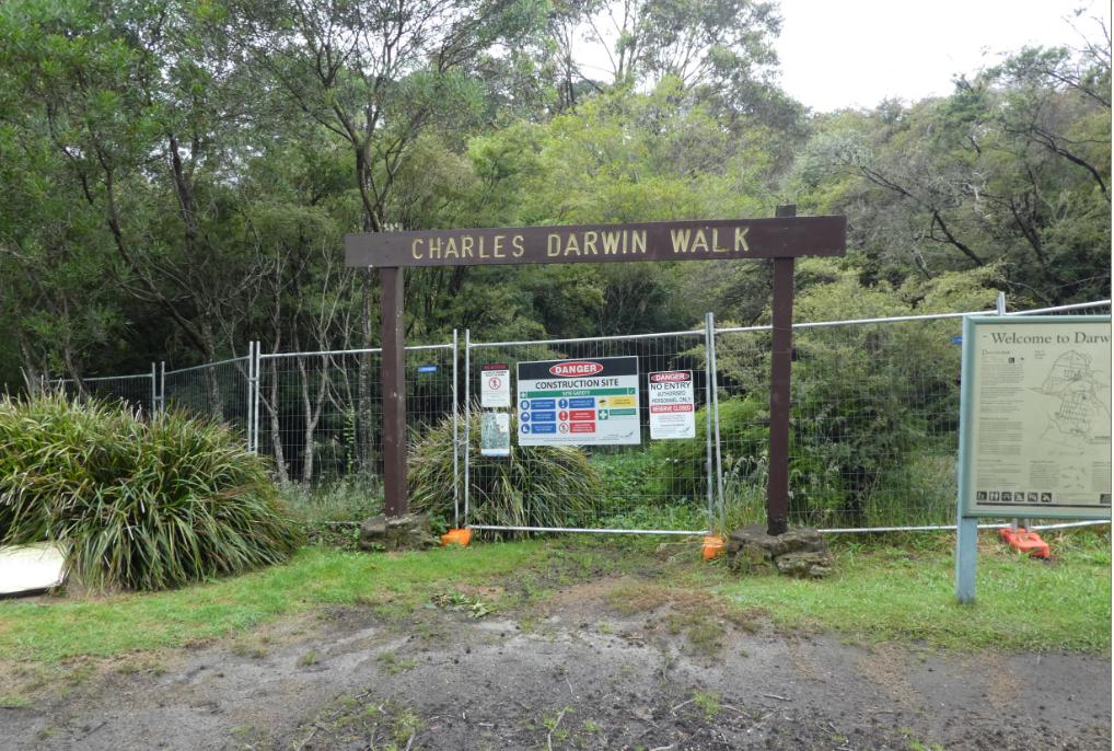
As we reconnoitre this 2024 trail in the officially recommended hiking direction, we commence with Charles Darwin Walk track section heading generally southward, then linking up with other connecting hiking track network generally heading westward over a series of different days to Scenic World.
Having hiked nearly all the track components of this trail over decades, the first impressions we observe are the new quality and robust track infrastructure having replaced the old and damaged. So well done!
This has been critical particularly along the Charles Darwin Walk track section due to the extensive destructive storm flooding from 7th – 9th February 2020 and later through 2021 and 2022. Charles Darwin Walk track has been closed pretty much since 2020 and was partly re-opened on 25th March 2024 as part of the opening of the Grand Cliff Top Walk.
However, we stop short of blaming the weather for the destructive flooding of Charles Darwin Walk track. This track section rails (parallels) Jamison Creek pretty much from The great Western Highway (under which it has long been treated culvert drain) 3 km south to then tumble over the actual falls of Wentworth Falls.
The main cause of the destruction of the track and debris damage to the creek was the flash flooding from the Blue Mountains Council spillway at Wentworth Falls Lake situated about 700 metres upstream of the highway culvert. Also contributing has been the decades of Council neglect of the track infrastructure, poor stormwater controls and absence of hydrological management of the riparian zone of the creek through Council lands.
Council’s old start version to Charles Darwin Walk. It was completely closed at the time following the flooding destruction, and remained closed for four continuous years. The true start is 400 metres upstream from the Weatherboard Inn site by the Jamison Creek adjacent to what has since become Pitt Park. [Photo by Steven Ridd, Thursday 31 st December 2020].
This new footbridge is an example of the robustness of the infrastructure.
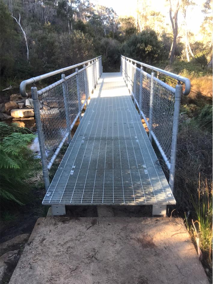
A new quality galvanised steel footbridge over Jamison Creek, this one located just north of the sewer-pipe bridge. It is very safe. [Photo by Steven Ridd, Wednesday 18th June 2025]
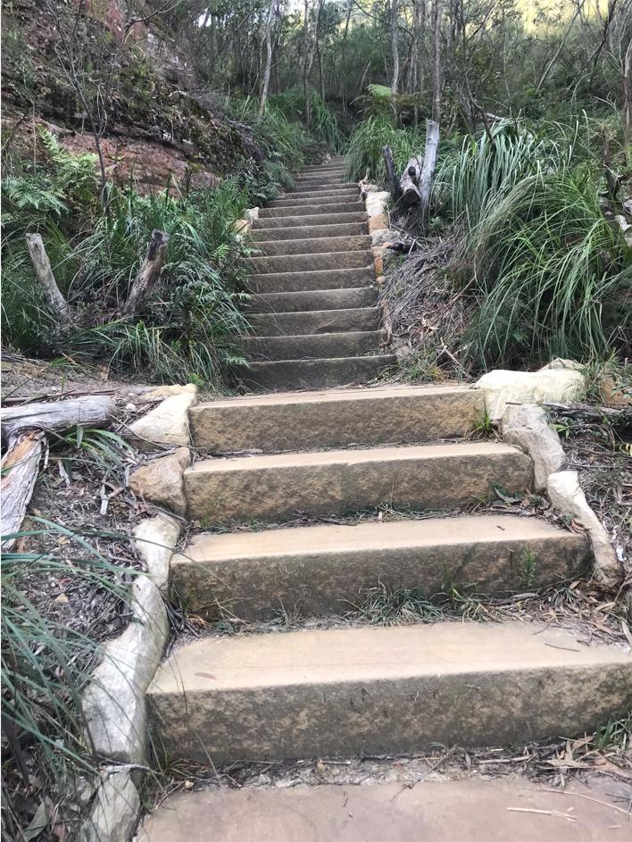
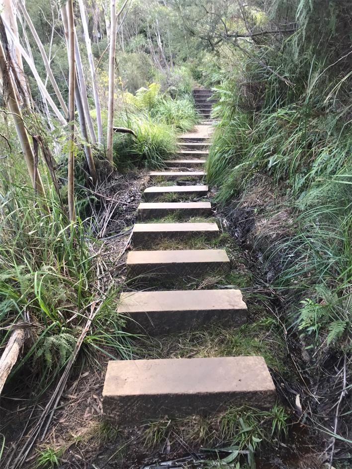
We also note the quality new ‘convict pick’ hewn style sandstone staircases which have made this track slight wider than previously so as to better accommodate opposing hikers en route. The stone steps seem to be of a consistent size and dimensions for consistency in step ‘tread’ and ‘riser’ for both safety and consistency in hiking gait (step length and stead height).
The top surfaces of the steps have a consistent pick mark pattern which adds to the boot grip to minimise slippage in wet and mossy conditions. The staircases are of a manageable angle of around 30 degrees, and the additional side stone edging assists in mitigating erosion, keeping hikers on track, protecting the native vegetation and assisting with hiker visibility in poor visibility conditions (depleting daylight/low cloud).
These successful results would seem to be consistent with Australian Standards, namely:
- AS2156.1: 2001 Walking tracks – Design, construction and maintenance
- AS2156.2: 2001 Walking Tracks Infrastructure Design
An example of a new best practice Australian Standard sandstone hiking track staircase work of art constructed along a section of this Grand Cliff Top Walk trail. It is located along this trail we label as Segment 4 ‘Gordon Falls Picnic Reserve to Leura Cascades Picnic Reserve’. It is specifically between Olympian Rock lookout and Tarpien Rock lookout. [Photo by Steven Ridd, Thursday 17th July 2025].
We observed the 30 degree angle grade, the consistent tread/riser/standstone block steps adding extra track width, plus the side rock bedding enveloping the staircase. It is a work of stone-masonry art, its a very durable and natural material and it aesthetically blends into the natural landscape. That’s why the hiking track photos look good.
So again, well done to all involved – staircase designers, stonemasons, track labourers, and of course the helicopter pilot(s) who treacherously crane-lifted the materials into convenient positions down through the trees – it’s not gone unrecognised.
Raised stepping stone track along the Prince Henry Cliff Walk track section between Olympian Rock and Tarpien Rock These sandstone blocks are raised above the natural ground because this section passes through a sensitive wet swamp due to the presence of a watercourse flowing frequently from right to left, so allowing for the water flow. We observe the stone blocks are uniformly the same dimensions and spaced equidistant apart – about 500mm centre to centre, 600mm wide and with a 30mm depth and 20mm above the ground. They make for an easy gait traverse for anyone about 183cm tall like me. [Photo by Steven Ridd, Thursday 17th July 2025].
Other noted trail upgrades are of many key lookouts – notably Elysian Rock (below), Olympian Rock, Tarpien Rock and Honeymoon Point. We also note the new steel bridge spanning the recent landslip near Buttenshaw Bridge below historic Leuralla mansion.
Elysian Rock lookout upgraded (in background), having added a new wide platform (in foreground) to facilitate visitor groups to congregate back from the limited small fenced lookout itself. [Photo by Steven Ridd, Thursday 17th July 2025].
This new platform suggests a Council intended facilitation to encourage bus/coach load visitation as a tour stop at Elysian Rock lookout. This location is a track junction of the Prince Henry Cliff Walk main track section with a staircase shortcut (350 m) ‘Elysian Rock Access Walk’ up to nearby exclusive residential Olympian Parade near Balmoral Road, Leura.
‘Elysian Rock Access Walk’ – offers a shortcut foot staircase and pathway connection between residential Olympian Parade to tourist attraction ‘Elysian Rock lookout. [Photo by Steven Ridd, Thursday 17th July 2025].
We observe that there is an existing shared local bus stop/Blue Mountains Explorer bus stop at the top of ‘Elysian Rock Access Walk’ in Olympian Parade, just opposite the Balmoral Road intersection.
Perhaps by Council creating this wide platform it has future plans to encourage private coaches to use this specific lookout as a short vista tour stop on a regular basis? If so, did Council ever engage in any prior resident community consultation about this?
We know they and Parks Service did with Gordon Falls Picnic Reserve just down the street, since Nature Trails Tour Director, Steven, attended a number of onsite community consultation sessions in his capacity as Conservation Consultant for The Habitat Advocate.
Critique #2: Trail Wayfinding Signage Plagiarism of Nature Trail’s logo
We were informed by our mates in May 2025, that they had observed a copy of Nature Trail’s business logo on multiple wayfinding hiking track signages along Prince Henry Cliff Walk, plus similarly publicised in the local newspaper.
The images looked just like Nature Trail’s tour business logo.
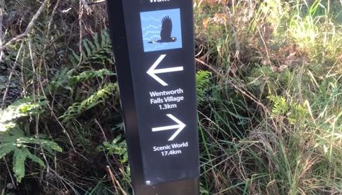
Official trail wayfinding signpost specific to this ‘Grand Cliff Top Walk’ which has plagiarised Nature Trail’s business logo. (Close up below). Note the sign distances don’t add up to the 19.7 km; try 18.7 km may be? [Photo by Steven Ridd along Charles Darwin Walk track just south of the Council sewerpipe bridge, Wednesday, 18 June 2025].
This is Blue Mountains Council’s plagiarised/unauthorised theft of Nature Trail pre-existing business logo. (See our logo since 2018 below). Council and their Parks Service brethren have used since 2024 as the wayfinding sign throughout the trail for this new marathon concept trail. It features the exact same copy of our black cockatoo silhouette with the only difference being Council shot her mate – hence the ghostly white entrails. We’re content to thus modify it for our use.
Nature Trail’s copyrighted business logo since 2018:
Nature Trail’s Tour Director, Steven Ridd, created this integrated logo/motto/tagline design back in 2014, modified in 2018.
It is a version of our original one (below) that Steven designed in 2013, who had commissioned Katoomba Blue Mountains local artist Lyn Naismith to paint specially for Nature Trail. In the original version it was a pair of endangered Glossy Black Cockatoos native to the Blue Mountains – male and female, each having slightly different in feather colourings.
![]()
Soon after, Steven in June 2025 discovered the government’s plagiarism of his business logo design. He soon rightly complained to both Blue Mountains {city} Council and to the Parks Service (NPWS) to communicate his displeasure of having Nature Trail’s creative original logo ‘nicked’ by government.
We point out that since 2019, Nature Trail has copped continual intimidation and business denial ongoing by the NSW Government in many ways:
- Bushfire emergencies lockdowns
- Ongoing landslip closures due to government stormwater neglect
- Pandemic lockdowns – (Feb 2020 through to Nov 2022)
- NSW Government grant repayment extortion (Service NSW)
- Our tour vehicle licensing extortion threats of $110,000 by the NSW Government’s ‘Transport for NSW’ department’s P2P transport Commissioner
- Nature Trail logo theft by NSW Governments (NPWS) ‘Parks Service’.
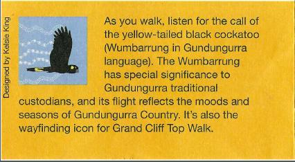
Above left reads “Designed by Kelsie King”? Bullshit, try nicked from Nature Trail!
Why couldn’t Kelsie design her own artwork and so be honest about such a personal achievement, like a different native Blue Mountains bird species or fauna or flora, but at least some design genuinely original. Good luck to her and any artist.
But thieving our creative artwork and claiming it as their own? Not happy Jan!
Here are two complaints by Nature Trail complained to the relevant government agencies about their blatant joint unauthorised plagiarism of our logo for their commercial self-serving benefit:
NPWS (Parks Service) plagiarises Nature Trail’s copyright logo
Critique #3: The true hiking length of this is far more than the officially claimed “19.7 km”, or other publicised variants
Here’s the Parks Service’s trail distance guesstimate from its dedicated webpage for this trail:
Grand Cliff Top Walk, NPWS (Parks Service) website, < ^https://www.nationalparks.nsw.gov.au/things-to-do/experiences/grand-cliff-top-walk [Accessed 2025-07-30].
Various governmental and promotional literature offer up differing lengths of this newly amalgamated trail. So is the trail’s actual hiking distance 19.7 km or 19 km or 18.7 km, or some other length?
Frankly, the 19.7 km overall trail length, which amalgamates a dozen shorter tracks into one epic monster, approximates a half marathon (being officially a mostly flat road running event of a measured 21 km).
Yet this amalgamated trail is not along a flat road (except for 1km section along Sublime Point Road), rather most of the trail involves climbing and descending hundreds of track staircases. We know because Nature Trail has just physically done this.
A office bound string measurement test peeled over a map on a desk won’t come close to the trails true undulating hiking length.
We offer up valid critiques about this unconfirmed mystery trail distance possibilities, until governmental independent and public coughing up with the truth:
(1) For one thing, there is no indication that the trail’s true hiking distance (up, down, and around) has actually been professionally measured by any independent surveyor. So the 19+ km is likely guess work by bureaucrats and their marketing department. She’ll be right?
(2) Secondly, our research has confirmed that the track’s new wayfinding signage from Day 2 track start at Gordon Falls Picnic Reserve pointing toward Scenic World is quote “7.7km”, but don’t take our word for it…
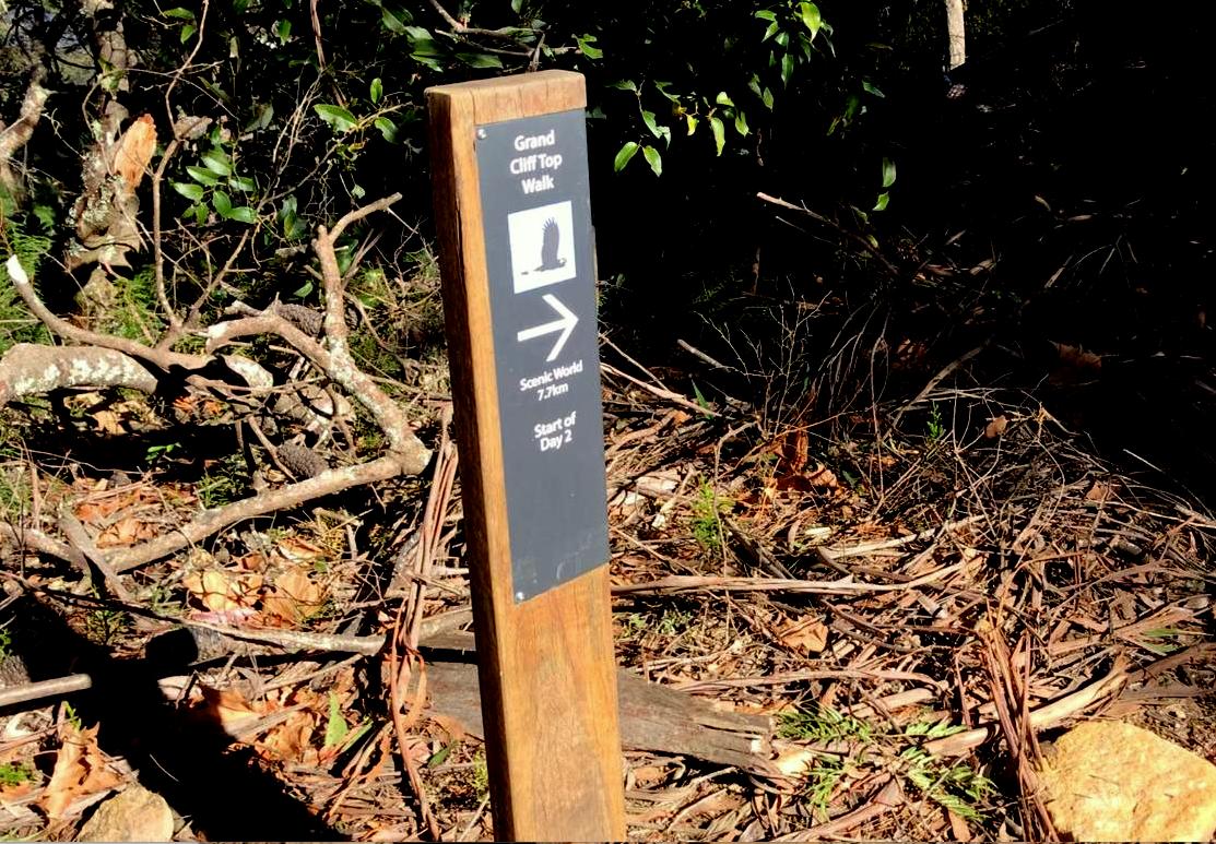
Grand Cliff Top Walk (2024 version) – a wayfinding sign on the trail beside Gordon Falls Picnic Reserve, which indicates the officially recommended direction of continuing hiking travel westward to “Scenic World 7.7 km ” from “Start of Day 2“. [Photo by Steven Ridd, Friday 4th July 2025]
So, what is the source of this hiking track distance segment and so can it be relied upon by hikers planning and attempting it? We say no!
We ask this not for petty reasons, but because our historical research differs to the 7.7 km to 9.5 km. Well, that is approximating a 2 km underestimate, so translating to a quarter distance understatement.
Such official understatement of hiking distance of this mega trail is unsafe guidance for would-be hikers considering it.
This is in terms of:
- The trail’s understated on ground hiking distance
- The hiking grade considering especially that the officially published recommendations are that it can be easily hiked in just two days (by young families with toddlers displayed in the official promo literature)
- The poor track condition in which much of the unrepaired sections remain dilapidated, dangerous and unsafe.
Yet the 2024 official signage contradicts historical records of this track, the same track start-to-end originally named the Prince Henry Cliff Walk having been constructed in 1934 and taking exactly the same route, thus:
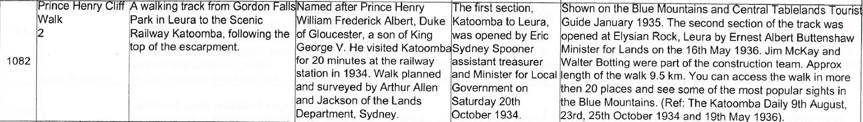
Prince Henry Cliff Walk [ Source: ‘Upper Blue Mountains Geographical Encyclopaedia’, 2001, 2nd. Ed., by Brian Fox, published by Brian Fox, Bathurst, Australia. ISBN 0 9578737 1 9, page 134].
(3) Thirdly, a surveyor can measure hiking track distance using a variety of tools, including measuring wheels, GPS devices, and even calibrated paces. While measuring wheels offer accuracy on smooth surfaces, GPS devices are useful for navigating and tracking distance on trails, and understanding your pace allows for estimations on uneven terrain. [Source: Google Maps AI – how unreliable such unsourced unaccountable referencing may be].

(4) Basic Geometry calculates that there is an increased hiking distance from travelling along a flat level surface compared with doing so up and down.
The Australian Standard for the angle for a hiking staircase is around say 30 degrees slope to be safe and reasonably and consistently hikeable. So if we plug n that 30 degrees into a triangular calculator (as below) we find that the actual climb/descent distance being hiked is 15% more than on flat ground.

This Geometry 101 right-angled triangular diagram reveals that a 30 degree angled staircase adds 15% to a otherwise horizontal (flat) distance hiked. It also fails to factor in the additional physical exertion required. [Source: [Source: Trigonometry Calculator – Right Triangles, ^https://www.carbidedepot.com/formulas-trigright.asp]
So are we now up to a 24 km overall hiking distance yet? Who really knows?
And this is before factoring in the current multiple track closures and detours. The trail concept is a sad joke. Moreso, the hundreds of staircase climb and descents, especially given uneven ground and angled awkward surfaces make the hike so much more difficult, more risky and so more time consuming. To try to attempt this trail in the officially recommended two days is more than Grade 3. It is designed for elite ultra-marathon runners and we deem it at such compressed 2-Day duration and pace at a Grade 5?
What were they thinking?
(5) We recommend that Parks Service be honest and trustworthy, and contract an independent Google mapping surveyor and utilise its latest GPS tracking technology to hike the entire 2024 version of this ‘Grand Cliff Top Walk’ (supervised by the Parks Service) and GPS measure its exact hiking length and then formally publish that hiking distance.
Critique #4: Governmental renaming of historic track seems politically motivated cultural ‘Cancel Culture’
The recent term ‘cancel culture‘ is politically biased. It seeks to undo patent history, as if that history ever existed. So the concept is rather fabricated cultist driven by an ulterior ideological motive.
We consider such to be just propaganda crap, and invariably of the globalist leftist side of politics.
Just because something like named tracks had a collective or societal agreement in good faith at that time, subsequent new perceptions may disagree with history. But that does not mean objectors with some fantasy self-righteousness imagine what they would like to have been, have any right to deny such historical reality as if it never existed in their head.
History right or wrong is recorded historical fact, warts and all. Fantasy is for objectors to read fiction and just re-imagine their sense of alternative idealism. That’s perfectly ok to support their re-invented headspace world view.
Why have the Parks Service (NPWS) jointly with Blue Mountains {city} Council chosen to undo and eradicate the many traditional and well-known names of the historic hiking tracks associated and replaced by this newly named amalgamated ‘Grand Cliff Top Walk’?
In order from east to west these are those historic track names:
- Charles Darwin Walk
- Weeping Rock Circuit
- Wentworth Falls Lookout Track
- Hippocrene Falls Walking Track
- Princes Rock Walking Track
- Eagles Nest Breakfast Point Walking Track
- Undercliff Walk
- Overcliff Walk
- Valley of the Waters Track
- Lillians Bridge Track
- Pool of Siloam Track
- Prince Henry Cliff Walk
Recreational hiking in the Blue Mountains dates back to the early 19th Century.
“The Blue Mountains boasts one of the most complex track systems of any national park in Australia. Dating from as early as 1825, around 60 per cent of the tracks have national, state or regional significance. Follow in the footsteps of early European tourists along the many historic tracks near Katoomba and Wentworth Falls, like Princes Rock walking track. Discover mining heritage along the challenging Ruined Castle route, or head down to Federal Pass, built in 1900. As you descend the Giant Stairway, spare a thought for the men who built it by hand using picks, shovels, crowbars and dynamite.”
[SOURCE: ^
https://www.nationalparks.nsw.gov.au/things-to-do/walking-tracks/prince-henry-cliff-walk/learn-more ]
If we consider just two of the above, the Prince Henry Cliff Walk, which extends from Gordon Falls Picnic Area to Scenic World, it holds a socially historic value that deserves hikers respect.
Charles Darwin Walk:
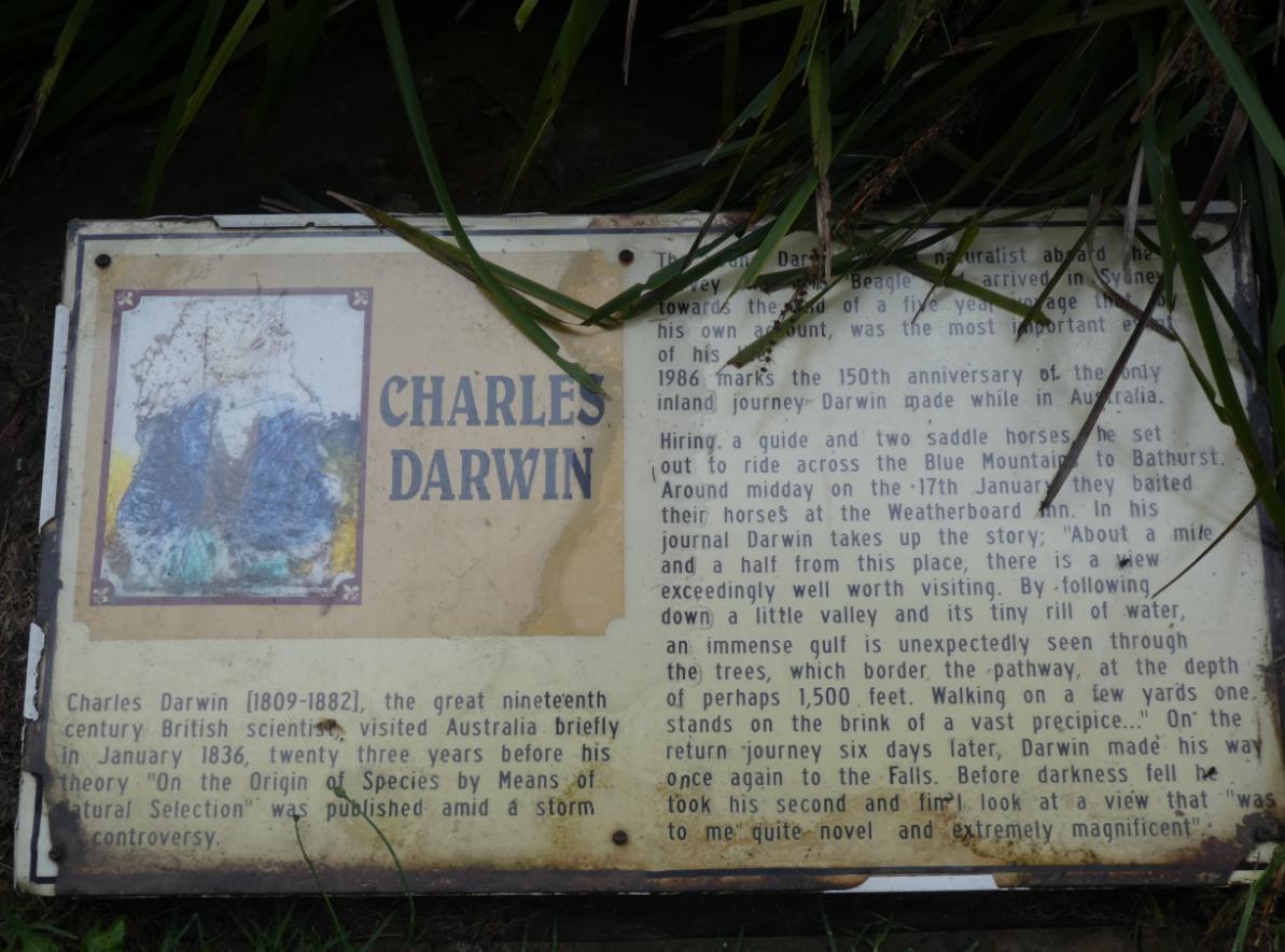
Old informational sign on site at the Council start of Charles Darwin Walk – since removed. More cancel culture?
Prince Henry Cliff Walk:
“Prince Henry Cliff Walk is named in honour of Prince Henry William Frederick Albert, Duke of Gloucester, a son of King George V and Queen Mary. Prince Henry visited Australia and Katoomba by train in 1934. The New South Wales government of the day engaged hundreds of unemployed young men between 1934 and 1936 to construct the track by hand as a means of keeping them gainfully employed and to create a healthy tourist visitation experience for the Blue Mountains.”
[Source: ^https://sydneyuncovered.com/prince-henry-cliff-walk/]
“Prince Henry Cliff Walk is listed on the State Heritage Register as a walking track of historical and aesthetic significance (Item K014).
Then Katoomba local council funded the track, suitable for “comfortable walking for pedestrians of all ages and conditions, linking many of the cardinal attractions of the Jamison Valley escarpment at Leura and Katoomba, is a significant historic token of the efforts to repair the Mountains economy and to serve a public need after the worst of the Depression of the early 1930s. The long track has considerable historic significance at the local level”..and has aesthetic significance at the local level.”
[Source: ^https://www.environment.nsw.gov.au/heritageapp/ViewHeritageItemDetails.aspx?ID=1170735].
Critique #5: The name ‘Grand’ risks confusing visitors with the ‘Grand Canyon’ track
Critique #6: NSW Government $13 million funding was not prioritised to repair and re-open historical and popular tracks, long closed
It went to a bureaucratic ‘concept’ new mega trail instead, which few will use, let alone complete
Critique #7: Multiple Sections of This New Trail Remain Closed
At the time of our initial scouting of this re-opened trail in February 2025…
- Charles Darwin Walk (Fletcher Street to Weeping Rock)
- Prince Henry Cliff Walk (from Gordon Falls to Tarpeian Rock)
- Leura Cascades (Round Track from Leura Falls up to Leura Cascades)
So how can politicians have very publicly declared it to be officially opened on 25th March 2024?
Critique #8: The First Half of this Trail is Not Near Any ‘Cliff Top’
So this means that the re-naming of this trails as the Grand Cliff Top Walk is a misnomer, and so misleading
Critique #9: Many track sections have not been upgraded, yet remain hazardous
Large exposed tree roots across tracks
Worn down-sloped stone steps on staircases
Extensive eroded track sections with raised old treated-pine step terracing
Unfenced old makeshift side tracks leading to sheer cliff edges (eg: Gordon Falls Lookout)
Critique #10: A more than 1km section requires hikers to walk on busy Sublime Point Road
From Fairmont Resort to Carleton Road
This poses a serious pedestrian hazard
No footpath infrastructure has been has been installed
Critique #11: Lack of vital public facilities
Promoted as a family trail, yet…
weather shelters
rest seating
drinking water n
Few public toilets – only at Wilson Park, Wentworth Falls Picnic Reserve (off track but no direction signposting from the Grad Cliff Top Walk trail)
No signage for public toilets – extensive evidence of ’tissue paper toileting’ along track
Fairmont – only guest toilets
Scenic World – only guest toilets
Critique #12: Council has recently installed timed parking meters
Visitor parking is up to 8 hours, then fines apply.
Discouraging extended visitation
Yet large buses are immune from such metered parking rules – rules for independent individual/family travellers, but not for Sydney coach mass commercial tourism
Critique #13: This mega trail concept offers no appeal to most hikers
Critique #14: Trail concept not designed for typical hikers
This mega trail concept is not designed for typical hikers, but instead seems to be clandestinely designed for the growing commercial ultra-marathon market as an unscrupulous cost recovery exercise
(E) Nature Trail’s Trail Variations:
With this particularly newly upgraded trail officially re-launched by the NSW Government in 2024, Nature Trail has adopted its own unique approach to consider offering it as a potential hiking tour.
We initially consider it to be a new hiking concept of variable forest ambience trek experience from Katoomba to Wentworth Falls. It’s overall length is over at least 20 km to officially do in 2-days, which is ‘not for the faint-hearted’, so Nature Trail adopts a more relaxed and multi-day approach to this trail. On this trek we only travel in daylight hours in half day segments. This is our starting position.
The prime hiking track component of the trail Prince Henry Cliff Walk along the Jamison Escarpment plateau top (Katoomba to Leura) which was partially upgraded (mostly during 2023 and 2024) by track builders and lift helicopters contracted to the local Blue Mountains Council and the Parks Service of New South Wales (NSW) from $13 million grant funding from the NSW Government.
This overall trail was in 2024 re-branded by the above government agencies as the Grand Cliff Top Walk and many sections of the hiking track sections are historic (back to the late 1800s) and remain in an old state of repair (eg: steps in either treated-pine timbered boardwalks/staircases, old sandstone or bare earth/mud), so the track conditions currently vary in standard.
(F) Trail Summary Specifications:
| Nature Trail Tour Title: | Grand Cliff Top Walk Trail |
| NT Tour Code: | MT-GCT |
| NT Tour Code Description: | Multi-Day Trek |
| Tour Category | Tailored |
| Trail Official Opening Date: | Monday 25th March 2024 |
| Tour Current Status: | Scouted> Recce > |
| Trail Title: | Grand Cliff Top Walk |
| Trail Hike Length: | 24 km |
| Starting Location: | Katoomba Railway Station |
| Finishing Location | Wentworth Falls Railway Station |
| Tour Offering (Duration): | Six separate 1/2 day hikes |
| Transport Transfers: | Blue Mountains Region only transfers included. (ie: Not Sydney) |
| Tour Fees: | Nil. Nature Trail currently runs as a non-commercial venture. If the NSW Government compliance costs and red tape is removed, we will consider relaunching commercially. |
We estimate the overall hiking distance of this trail to be around 24 km. However due to the trail’s distance, juxtaposition to upper central Blue Mountains villages and disconnectivity, Nature Trail offers this tour to our guests as Multi-Day Trek, this by segmenting it into 7 x Half-Day Hike segments including all road transport that we offer by dedicated chauffeured private transfers.
However, not all 7 segments need be undertaken. Nature Trail offers this particular tour simply as as a pool of choice to our guests, as we do with all our tours. Currently we are reconnoitring this particular trek and designing variations quite different to its official brochure.
Our initial tour design proposal is to offer this as a bespoke guided tour on a private guest basis in the following choice of tour delivery options:
Our Suggested Tour Options:
(A) Cliff Top Full Mounty – as one tour trek of the entire hiking tour end-to-end (Katoomba to Wentworth Falls) over 7 half days (back-to-back, or spread further with breaks) with all flexible transport transfers on demand;
(B) Cliff Top Choice Tour: A choice of any half-day segment or any half day segments in any order or indeed section sample;
(C) Cliff Top Blended Tour: includes (B) plus other of our tour options, as our guests prefer – hiking or non-hiking, whatever.
Tour options will fairly vary according to our guests’ choices.
Nature Trail’s tour design for what we entitled our ‘Grand Cliff Top Walk Trek‘ is currently an unfinished work-in-progress. We will continue with our on-ground reconnoitres, practice trips, fine tuning, and government red tape before we offer this tour commercially.
Meanwhile, Nature Trail provides interested visitors to the following relevant background reading about this particular proposed tour route.
(F) Variations To This Trail:
Our research efforts into what is a concept track route of amalgamated shorter and in some cases historic tracks, has revealed that the title of this track Grand Cliff Top Walk, has itself been also plagiarised by government.
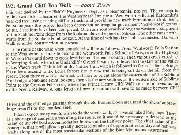
‘Grand Cliff Top Walk – Original Project, 1980s’. [SOURCE: ‘How To See The Blue Mountains’, 1989, 2nd Ed., by Jim Smith Ph.D, printed paperback book, pp 138-139.
(G) Our segmented guided delivery of this trail:
>SEGMENT 1: Wentworth Falls Railway Station to Conservation Hut
>SEGMENT 2: Conservation Hut to Fairmont Resort
>SEGMENT 3: Fairmont Resort to Gordon Falls Picnic Reserve
>SEGMENT 4: Gordon Falls Picnic Reserve to Leura Cascades Picnic Reserve
>SEGMENT 5: Leura Cascades Picnic Reserve to Echo Point Lookout
>SEGMENT 6: Echo Point Lookout to Reid’s Plateau
>SEGMENT 7: Reid’s Plateau to Explorers Marked Tree
Nature Trail exclusive transfer with tag-along support complimentary included for each segment (at start and finish) within the Upper Blue Mountains.
References and Further Reading:
[DISCLAIMER: Nature Trail researches its source information as part of this article, which we privately record for our own personal referencing. If any of the references below ever become ‘dead links’, that is, deleted from public access online; we always have retained a full documented copy of that original reference document and every other listed in this section below. This ensures our article stands up truthfully to having relied upon the factual record made public online which we have sourced at the time. So, if ever challenged later in law, we can reproduce that and any document in toto as evidence.]
[1] ‘Grand Cliff Top Walk unveiled in Blue Mountains‘, 2024-03-25, Blue Mountains Gazette (newspaper), ^https://www.bluemountainsgazette.com.au/story/8566633/grand-cliff-top-walk-opens-connecting-wentworth-falls-to-katoomba/
[2] ‘Grand Cliff Top Walk – Blue Mountains‘ brochure, National Parks and Wildlife Service of NSW, (undated), DCCEEW, 2 pages
Loading...
[3] ‘Grand Cliff Top Walk‘, National Parks and Wildlife Service of NSW (Parks Service), website, ^https://www.nationalparks.nsw.gov.au/things-to-do/experiences/grand-cliff-top-walk
[4] ‘Grand Cliff Top Walk‘, Blue Mountains {city} Council, ^https://www.bmcc.nsw.gov.au/grand-cliff-top-walk
[5] ‘NPWS (Parks Service) plagiarises Nature Trail’s copyright logo‘, 2025-05-30, Steven Ridd, Tour Director, Nature Trail, Mountains Drums blog, ^https://naturetrail.com.au/blog-post/npws-parks-service-plagiarises-nature-trails-copyright-logo/
[6] ‘Blue Mountains Council (BMCC) plagiarises our business logo and then falsely claims it to be Gundungurra?‘, 2025-07-14, by Steven Ridd, Tour Director, Nature Trail, Mountains Drums blog,^https://naturetrail.com.au/blog-post/blue-mountains-council-bmcc-plagiarises-our-business-logo-and-then-falsely-claims-it-to-be-gundungurra/
[7] ‘Blue Mountains ‘Grand Cliff Top Walk’ – Misleading Flyer & Press Release‘, 2025-07-05, by Steven Ridd, Tour Director Nature Trail, ^https://naturetrail.com.au/blue-mountains-grand-cliff-top-walk-misleading-flyer-press-release/
[8] ‘Blue Mountains ‘Grand Cliff Top Walk’ – a misleading promotional article‘, 2025-07-05, by Steven Ridd, Tour Director Nature Trail, ^https://naturetrail.com.au/blue-mountains-grand-cliff-top-walk-a-misleading-promotional-article/
[9] ‘MT-GCT Grand Cliff Top Walk Trek‘, 2025-07-05, by Steven Ridd, Tour Director, Nature Trail, ^https://naturetrail.com.au/mt-gct-grand-cliff-top-walk-trek/
[10] ‘Blue Mountains ‘Grand Cliff Top Walk’ Our Critique – SEGMENT 1: Wentworth Falls Railway Station to Conservation Hut‘, 2025-07-05, by Steven Ridd, Tour Director, Nature Trail, ^https://naturetrail.com.au/blue-mountains-grand-cliff-top-walk-our-critique-segment-1-wentworth-falls-railway-station-to-conservation-hut/
[11] ‘Blue Mountains ‘Grand Cliff Top Walk’ Our Critique – SEGMENT 2: Conservation Hut to Fairmont Resort‘, 2025-07-05, by Steven Ridd, Tour Director, Nature Trail, ^https://naturetrail.com.au/blue-mountains-grand-cliff-top-walk-our-critique-segment-2-conservation-hut-to-fairmont-resort/
[12] ‘Blue Mountains ‘Grand Cliff Top Walk’ Our Critique – SEGMENT 3: Fairmont Resort to Gordon Falls Picnic Reserve‘, 2025-07-05, by Steven Ridd, Tour Director, Nature Trail, ^https://naturetrail.com.au/blue-mountains-grand-cliff-top-walk-our-critique-segment-3-fairmont-resort-to-gordon-falls-picnic-reserve/
[13] ‘Blue Mountains ‘Grand Cliff Top Walk’ Our Critique – SEGMENT 4: Gordon Falls Picnic Reserve to Leura Cascades Picnic Reserve‘, 2025-07-05, by Steven Ridd, Tour Director, Nature Trail, ^https://naturetrail.com.au/blue-mountains-grand-cliff-top-walk-our-critique-segment-4-gordon-falls-picnic-reserve-to-leura-cascades-picnic-reserve/
[14] ‘Blue Mountains ‘Grand Cliff Top Walk’ Our Critique – SEGMENT 5: Leura Cascades Picnic Reserve to Echo Point Lookout‘, 2025-07-05, by Steven Ridd, Tour Director, Nature Trail, ^https://naturetrail.com.au/blue-mountains-grand-cliff-top-walk-our-critique-segment-5-leura-cascades-picnic-reserve-to-echo-point-lookout/
[15] ‘Blue Mountains ‘Grand Cliff Top Walk’ Our Critique – SEGMENT 6: Echo Point Lookout to Reid’s Plateau‘, 2025-07-05, by Steven Ridd, Tour Director, Nature Trail, ^https://naturetrail.com.au/blue-mountains-grand-cliff-top-walk-our-critique-segment-6-echo-point-lookout-to-reids-plateau/
[16] ‘Blue Mountains ‘Grand Cliff Top Walk’ Our Critique – SEGMENT 7: Reid’s Plateau to Explorers Marked Tree‘, 2025-07-05, by Steven Ridd, Tour Director, Nature Trail, ^https://naturetrail.com.au/blue-mountains-grand-cliff-top-walk-our-critique-segment-7-reids-plateau-to-explorers-marked-tree/
[17] ‘Blue Mountains Best Bushwalks‘, 2016, 3rd Ed., by Veechi Stuart, printed paperback book, published by Woodslane Press Pty Ltd, Warriewood, Australia, ISBN 978 192540 32 9 9, Dewey No. 919.440504
[18] ‘How To See The Blue Mountains‘, 1989, 2nd Ed., by Jim Smith Ph.D, printed paperback book, published by Second Back Row Press Pty Ltd, Katoomba, Australia, ISBN 09093255 2 9
[19] ‘Upper Blue Mountains Geographical Encyclopaedia‘, 2001, 2nd. Ed., by Brian Fox, published by Brian Fox, Bathurst, Australia. ISBN 0 9578737 1 9
[20] ‘Trigonometry Calculator – Right Angle Triangles‘, ^https://www.carbidedepot.com/formulas-trigright.asp]
This webpage updated: 2025-07-28.