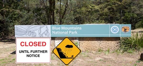
Yesterday the New South Wales Parks Service decided to blanketly close the entire Blue Mountains National Park of some 2690 km2 indefinitely. The huge area extends pretty much from Bilpin to Kanangra and from Warragamba Dam to Mount Victoria.
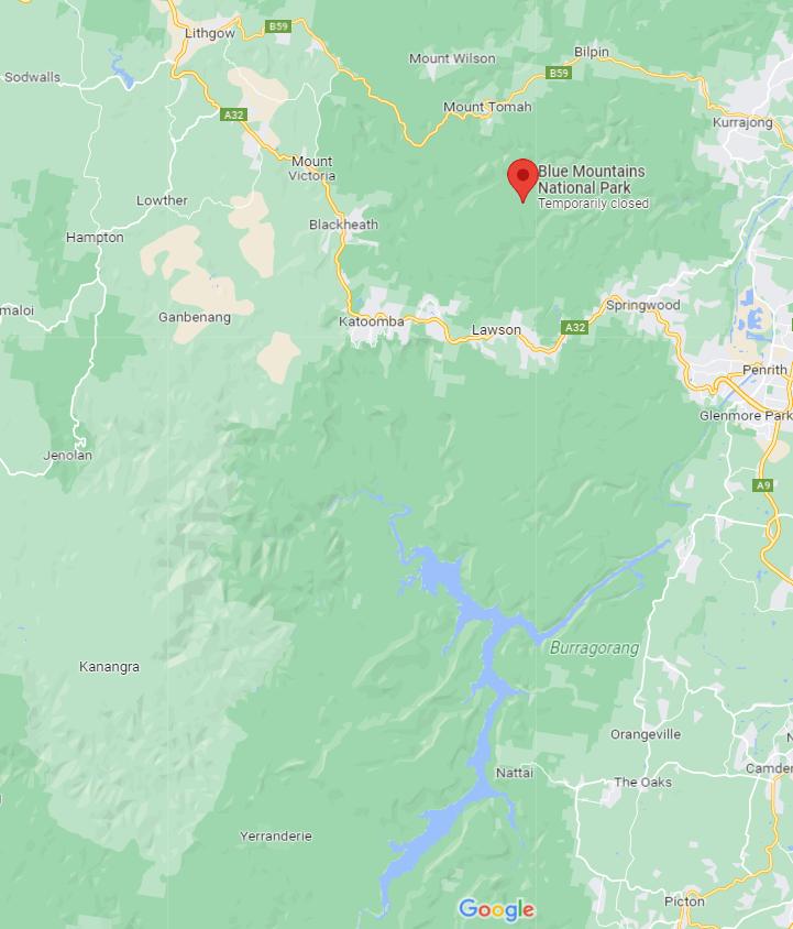
NSW Parks Service ‘Temporary Closed’ notice on Google Maps today
The reason for the blacket closure is simply the likelihood of well, rain.
What? Rain in the Blue Mountains? Who would have thought?
Mmm, make that the threat of drizzle – such a looming hazard hikers who may get wet.
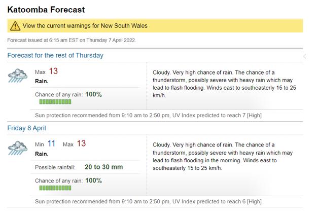
Katoomba weather forecast 7th April 2022 by Australia’s official Bureau of Meteorology
Worse is that if hikers choose exposed traverse cliff passes along a cliffedge escarpment track, well then boulders could dislodge and fall on them like the day prior at the known dodgy spot at Wentworth Pass/National Pass in the Jamison Valley.
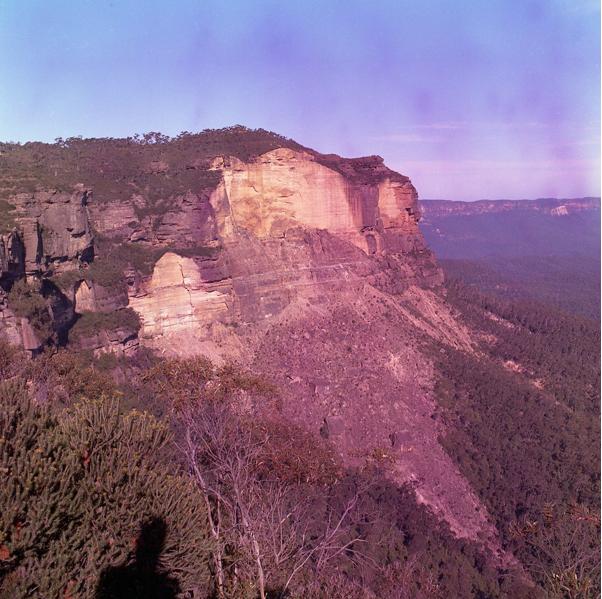
‘The Landslide’ south of Katoomba which occurred back on the night of 29th January 1931 as a result of coal mining tunnels dug below to extract kerosene shale by John Britty North’s Katoomba Coal and Township Land Co. Limited (now Scenic World).
May be the Parks Service is feeling guilty by its decision to recently re-opening Wentworth Pass but with no warning signs to hikers. This is in the wake of the tragic deaths of two tourists by a rockfall/landslip last Monday, which ironically was a sunny day.
Parks Service claims it inspected Wentworth Pass just days before the tragedy as part of a “routine track assessment programme”. What was inspected? What qualifications did the inspector hold? Did he/she hold qualifications geohydrology and with considerable local Blue Mountains geohydrological experience?
Probably not.
Meanwhile, Blue Mountains Mayor Mark Greenhill said on Tuesday 5th April: “Today I have asked council to close any tracks that are in at risk areas.”
So what if any routine track assessment programme does the Council propose to gauge the safety of its hiking tracks?
The holidaying family of five from England were based in Singapore and chose to hoilday in Australia after the imported China Virus pandemic lockdown lifted. They chose the Blue Mountains and then specifically to hike the little known and challenging Wentworth Pass for some reason (promise of waterfalls?). May be the decision was from a website or from a recommendation from someone locally, despite the track being Grade 4 ‘very difficult and so suitable for only advanced hikers.
The father Mehraab Nazir (49) and his younger son (9) were killed by the rockfall on Wentworth Pass and his wife (50) and second son (14) suffered serious injuries. Mr Nazir’s daughter (15) managed to hike out from the scene and currently remains under observation in Westmead Childrens Hospital. Mr Nazir’s wife also remains in a critical condition in an intensive care unit in Westmead Hospital, whilst the eldest son (14) has undergone surgery and is in a stable condition.
Were members of the family advanced hikers and what kit did they carry on this particular hiking trip?
This rockfall tragedy occurred around the same cliff escarpment area which took place back in November 2017 and killed Parks Service contractor Dave Gliddon and seriously injured his two co-workers while trying to make the National Pass safer.
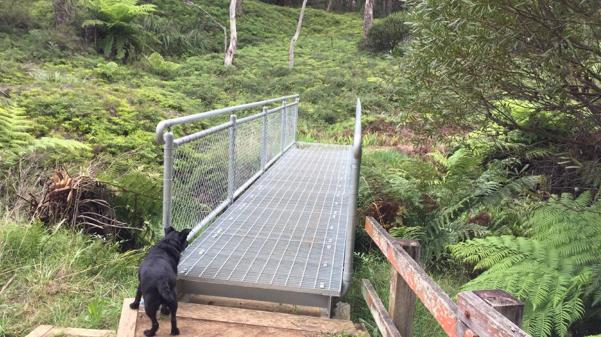
A memorial on this footbridge was dedicated to Dave Gliddon who had helped construct it across Jamison Creek along Charles Darwin Walk in Wentworth Falls – big of Parks/Council. The popular track has been closed since February 2020 due to flooding.
Professional hiking tours include a prior recent reconnoitre of the route and a hazard/risk assessment in advance of being offered and proceeding commercially. Given that the unresolved rockfall hazard of the nearby National Pass track was not safely remediated, that Parks Service has maintained the tracks continual closure since the tragic death of Dave Gliddon in November 2017, and given that the Cononer’s Report has not been made public, why was Wentworth Pass re-opened by the Parks Service a week or so ago, with no warning signage?
But such blanket closure of the entire Blue Mountains National Park is surely a bureaucratic over-reaction. It’s like a crash on the Great Western Highway results in shutting down the highway indefinitely?
And Blue Mountains weather since Monday has been simply characterised as drizzle and light showers.
It is unprecedented to close an entire national park due to the risk of drizzle. The New South Wales east coast has endured rain from the La Niña climate pattern off the Pacific Ocean on and off since February 2020 and some of the rain has pushed inland across the Blue Mountains, but very little compared with the Northern Rivers region.
As a hiking tour operator, Nature Trail will wisely opt to cancel in advance any booked hiking trip when the actual or forecast weather for the area includes the risk of thunderstorms (lightning), snow, high winds (on a clifftop hike) or if there is a bushfire alert.
But not for a rain or drizzle hazard? Getting wet while hiking is par for the course. We always advise to pack a rain jacket in case of rain.
It appears that the blacket closure has been imposed by NSW Premier Dominic Perrottet for legal reasons. He is worried that the family may sue the New South Wales Government for negligence given that the dead father Mr Nazir was a lawyer employed by Watson Farley & Williams in their Singapore office.
The tourist deaths could become a foreign diplomatic incident. It won’t help Blue Mountains tourism.
So this is the NSW Parks Service official announcement on its website since yesterday:
‘Closed parks: Blue Mountains National Park closed due to predicted weather event’
Blue Mountains National Park will be closed from 9am, Wednesday 6 April 2022 due to a predicted weather event. Please check park alerts daily for updates. This closure includes the Wentworth Falls area and the Kanangra-to-Katoomba (K2K) walking track.
Govetts Leap lookout, Evans lookout and the Blue Mountains Heritage Centre are the only locations that remain open in Blue Mountains National Park at this time.
(How generous. May be as long as tourists don’t get out of their car)
Affects 91 locations in this park:
• 4WD Oberon Colong historic stock route
• Acacia Flat campground
• Andersons trail
• Blackheath lookouts driving route
• Blue Gum Forest
• Blue Mountains Heritage Centre
• Blue Mountains Heritage Centre
• Blue Pool walking track
• Burralow Creek campground and picnic area
• Burramoko Ridge (Hanging Rock) trail
• Butterbox Canyon
• Charles Darwin walk
• Cliff Top walking track
• Conservation Hut
• Dardanelles Pass loop walking track
• Den Fenella walking track
• Dunphys campground
• Echo Point lookout (Three Sisters)
• Echo Point to Scenic World via Giant Stairway
• Empress Canyon
• Euroka campground
• Evans lookout
• Fairfax Heritage walking track
• Federal Pass
• Furber Steps-Scenic Railway walking track
• Giant Stairway
• Glenbrook Gorge track
• Golden Stairs walking track
• Gordon Falls lookout and picnic area
• Government Town campground
• Govetts Leap descent
• Govetts Leap lookout
• Grand Canyon
• Grand Canyon track
• Greater Blue Mountains drive
• Ingar campground
• Jack Evans walking track
• Jellybean track
• Jugglers Canyon
• Kedumba River Crossing campground
• Leura Cascades Fern Bower circuit
• Leura Cascades picnic area
• Lockleys Pylon walking track
• Lyrebird Dell walking track
• Mount Banks Road cycle route
• Mount Banks Summit walk
• Mount Hay Road – Leura
• Mount Hay summit walking track
• Mount Solitary walking track
• Mount Werong campground
• Murphys Glen campground
• Narrow Neck trail
• National Pass
• Nature track
• Nepean lookout
• Nepean River walking track
• Overcliff-Undercliff track
• Perrys lookdown
• Perrys lookdown campground
• Perrys lookdown to Blue Gum Forest walking track
• Pierces Pass to Blue Gum Forest walking track
• Portal lookout
• Prince Henry Cliff walk
• Princes Rock walking track
• Pulpit Rock lookout
• Pulpit walking track
• Red Hands Cave
• Red Hands Cave walking track – Blue Mountains National Park
• Rigby Hill walking track
• Rocket Point lookout track
• Rodriguez Pass walking track
• Round walking track
• Ruby Creek walking track
• Ruined Castle walking track
• Six Foot track
• Sublime Point lookout – Leura
• Three Sisters walk
• Tunnel View lookout
• Vale of Avoca lookout
• Valley of the Waters picnic area
• Victoria Falls walking track
• Weeping Rock circuit
• Wentworth Falls picnic area
• Wentworth Falls to McMahons Point
• Wentworth Falls to Woodford via Ingar campground
• Wentworth Falls track
• Wentworth Pass loop walking track
• Wollangambe Canyon 1
• Wollangambe Canyon 2
• Woodford – Oaks trail
• Woodford Station to Murphys Glen campground
Not much outdoors obviously
Talk about bureaucratic liability ‘arse covering’!
Just how much more can Blue Mountains tourism take from government incompetence? It’s more of the systemic mismanagment of Blue Mountains tourism on top of the neglected bushfires, landslips, pandemic lockdowns with $5000 fines for transgressors, train stoppages, road closures, Blue Mountains Council’s pebblecreting denying pedestrian access to high street retailers for nearly a year.
There is a theme in all this. The NSW state and local governments want to simply condemn the Blue Mountains out of its World Heritage status and be swallowed up into a Greater Greater Sydney.
National Parks deserved to be managed nationally, not by a state government that repeatedly cuts funding and resourcing.