Blue Mountains ‘Grand Cliff Top Walk’ Our Critique – SEGMENT 5: Leura Cascades Picnic Reserve to Echo Point Lookout
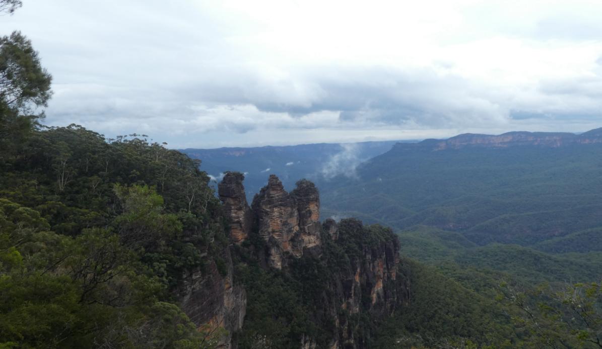
The Three Sisters from Spooners Lookout near Echo Point, Katoomba. [Photo by Steven Ridd, Saturday 6th February 2021]
On Friday morning 4th July 2025, Friends of Nature Trail chose our recce of this particular segment of the Grand Cliff Top Walk from west of Leura Cascades Picnic Reserve to Echo Point Lookout. This is because currently Leura Cascades Picnic Reserve is closed for council upgrade, plus a recent landslip on Round Track has close the track route as well.
The weather was clear, sunny cool winter’s day with no wind – so ideal.
Segment 5 hiking route map:
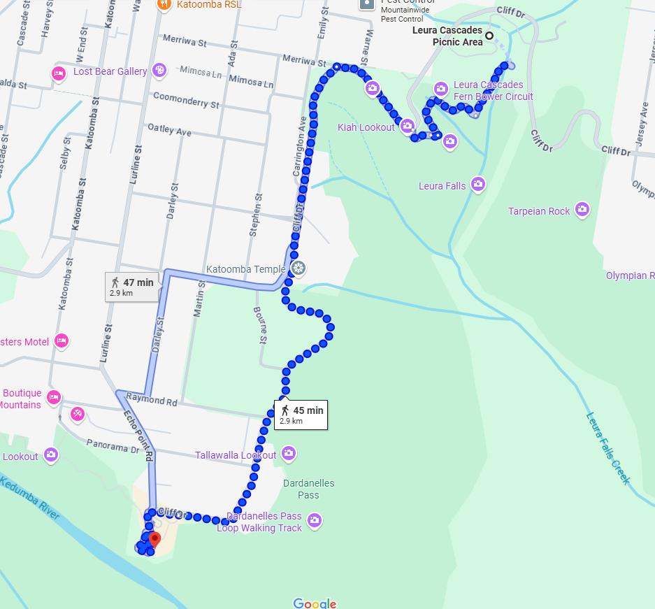
‘Grand Cliff Top Walk’ trail – Segment 5: From Leura Cascades Picnic Reserve (top right) to Echo Point Lookout (bottom left) this is a medium Grade 3km hiking track (when it re-opens again). Yet, we recommend it’s best to allow 4 hours for the track staircase hilliness, healthy exertion pauses, quality time to experience and photograph the numerous breathtaking lookout vistas above the deep Jamison Valley, and just holiday share. [SOURCE: Google Maps, 2025.]
It is important for interested hikers to be aware that this track segment similarly undulates up and down many track staircases, so adding to the grade exertion required to complete. It is no flat clifftop hike. We passed one cross-country marathon runner coming the other way on our reconnoitre.
In addition, there are a number of short side tracks to obtain breathtaking vista breaks worthy of factoring into the hiking experience and so duration allowance. There are also a few track junctions en route that take off down into the Jamison Valley and into the wilderness routes beyond, but at the time of our reconnoitre these were officially closed off for reasons of either recent landslips or track upgrading.
Plus, once arriving at Echo Point Lookout, realise that this is an iconic world renown tourist vista attraction and hub. This location deserves factoring into this half-day tour key side track lookout vista opportunities up, such as Spooners Lookout and getting close and personal to the unique ‘Three Sisters’ pagoda formation. Also, a toilet break, water top up, leisurely lunch choices and learn more here by exploring this famous lookout’s interpretative signage and visiting the Tourist Information Centre there.
There are frequent public transport services from Echo Point, and the place is usually rather understandably busy.
We don’t rush experiencing such unique natural attractions.
A trail section closure:
In frustration we discovered that Leura Cascades is still completely closed off to the public. We were warned.
But it was not just the picnic reserve being upgraded by Council, but the closure of the interconnecting track section of the old ‘Round Walk‘ track which very scenically left-rails Leura Creek from Leura Falls upstream northward via Leura Cascades to Leura Falls Picnic Reserve – regrettably still a work-in-progress nearly five years after its initial landslip closure.
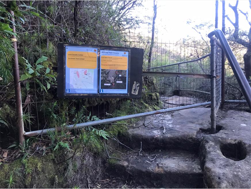
The relevant part of the sign reads: “Leura Cascades CLOSED between Amphitheatre Track and Prince Henry Clifftop (sic) Walk (Grand Cliff Top Walk)“. [The correct name is ‘Prince Henry Cliff Walk’)
This closure to another section of the Grand Cliff Top Walk, despite it being officially declared open by government on 25th March 2024, over a year prior. We recall the press release in the local newspaper.
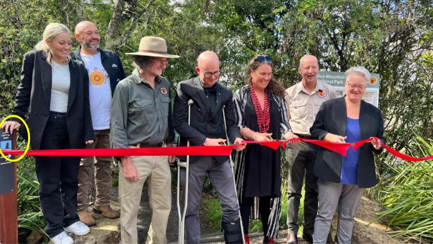
A Claytons trail opening – replete with ribbon cutting by politicians and hangers-on back on Monday 25th March 2024.
As an aside:
This ‘Round Walk‘ is one of two such descriptive ‘Round Walk’ side track diversions off the Prince Henry Cliff Walk; the second being in the Katoomba area off Prince Henry Cliff Walk situated between Reid’s Plateau and Scenic world via Juliet’s Balcony lookout.
The $13 million odd funding grant (including the Gordon Falls Picnic Reserve $2.4 million bit) received from the NSW Government for this newly conceived ‘Grand Cliff Top Walk, was undertaken without public consultation, jointly by Council and Parks Service.
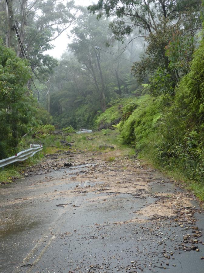
The Leura Cascades Picnic Reserve and interconnecting track network have been closed by Blue Mountains Council since a major landslip on 12 February 2020 following torrential rain. It was Council’s lack of adequate stormwater drainage above (~100m right) up in Grose Street that had caused the steep embankment to slip down covering a 30 metre section of Cliff Drive below.
Cliff Drive section impacted situated adjacent to the Leura Cascades Picnic Reserve. [Photo by Steven Ridd Thursday 31 December 2020, taken some ten months after the landslip event – grass can be seen long growing over the neglected debris from the landslip.]
Now we were aware of that, and local council has after five year finally re-opened Cliff Drive around Leura Cascades Picnic Reserve, but then close the Picnic Reserve to upgrade it for some reason.
Then it has also we discover on our reconnoitre that council has also closed Round Walk.
Given the recent landslips impacting the sandy Blue Mountains plateau landscape since 2020 (and much history prior) why was this Round Track section railing Leura Creek from the Picnic Area down to the Falls not protected from further landslips. It has thus forced yet another closure to this so-called Grand Cliff Top Walk. May be this trail naming is all wrong – how about ‘Dodgy Cliff Top Trail‘, or just return the separate namings to the way these multiple tracks have been historically since the late 19th Century!
All those taxpayer funds have yes, gone into best practice sandstone stair work and new culverts (necessitating many expensive helicopter crane lifts of construction materials in situ), but sensibly was any hydrologist gainfully overseeing the track infrastructure upgrade project so as to avert further landslip risks?
Backtracking from Kiah Lookout to Leura Cascades:
Since on the day of our reconnoitre, Leura Cascades was closed, Nature Trail, aware of this decided to at least ground-truth the Segment 5 track backwards from Kiah Lookout to the closure.
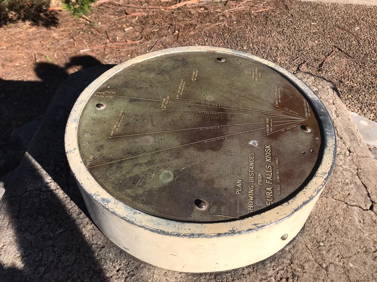
This is Kiah Lookout situated at the apex of the sharp bend in Cliff Drive around what was Solitary Café, currently named ‘Sequoia’.
This is the directional dial at Kiah Lookout
However, on our recce day we noted along the upgraded track between Amphitheatre Track and Round Track two recent landslips undermining the new sandstone blocks and killing adjacent native trees.
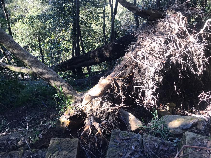
This recently fallen tree has the new sandstone staircase shown installed right up against it. The digging into the root ball in order to position the staircase into the soil, clearly undermined the tree’s stability/sustainability and caused the tree’s death. This particular location is under 100 metres below Cliff Drive below Kiah Lookout shortly after taking the first left track fork. (See our photo of that prior track junction below].
At the time when Nature Trail began is tour research in 2013, and scouting and reconnoitring tracks for suitable hiking options, an ideal track head location that we found the ideal was from starting at Leura Cascades Picnic Reserve. This is because it features the following benefits (when not closed by local council):
- Track head to multiple hiking tracks
- Adequate car parking
- Public toilets
- Drinking water top-up
- Out of the wind
- Weather shelters (rain, wind, lightning, shaded from summer sun)
- Picnic tables
- Historical place for interpretative guiding
Well, we choose to recce this track segment entering backward/eastward from The Rooster access back to Leura Cascades. We say this because our track photos do same, as follows:
The track segment of the Grand Cliff Top Walk (direction east to west) between Leura Cascades Picnic Reserve to Echo Point Lookout is fairly level initially, but then encounters many stone stairways up and down.
However, when we tried this segment, it was closed to the public between Leura Cascades Picnic Reserve and the Round Walk just west of Leura Falls. This meant we could only explore the track from ‘The Rooster’ backwards and eastward to the track closure at the Round Track above Leura Falls.
‘Kiah Lookout’ to ‘Echo Point’ track section:
Given that the Round Walk track section around Leura Cascades was still closed during Nature Trail’s reconnoitring, we returned to undertake the second section of this Segment 5 of the 2024 ‘Grand Cliff Top Walk‘ trail from Kiah Lookout to Echo Point Lookout heading westward following the officially recommended direction of travel.
We did this on a different day, Tuesday 22nd July 2025. Given this section is very short being under 2km hiking distance, a relatively easy grade, and which we well familiar; so Tour Director Steven Ridd decided to do this unusually solo. The weather was a mild 9o Celsius, no wind again, a few low patchy nimbostratus clouds lurking but fortunately it didn’t rain.
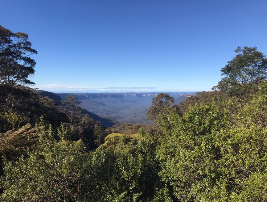
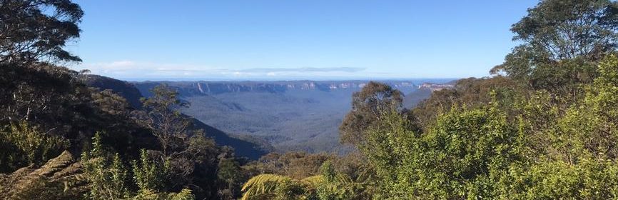
On this trail segment, a vista of the Jamison Valley and to the horizon beyond looking south-east from Cliff Drive opposite ‘The Rooster’ (restaurant) near Kiah Lookout, Katoomba towards Mount Gibraltar, just visible some 80km away. [Photo by Steven Ridd 2025-07-04].
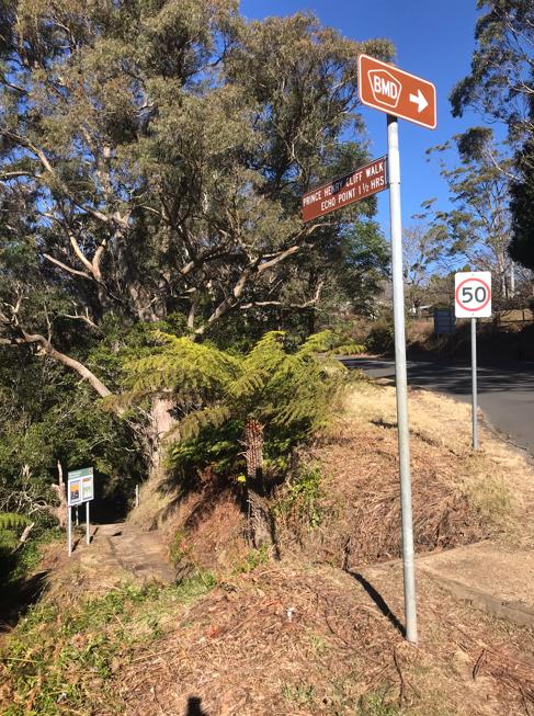
The above vista is conveniently accessible on a short side track off Grand Cliff Top Walk trail. This Prince Henry Cliff Walk track section links with a short 50m track junction northward to Cliff Drive about 20m from the intersection of Merriwa Street in Katoomba opposite the old famous The Rooster French Restaurant.
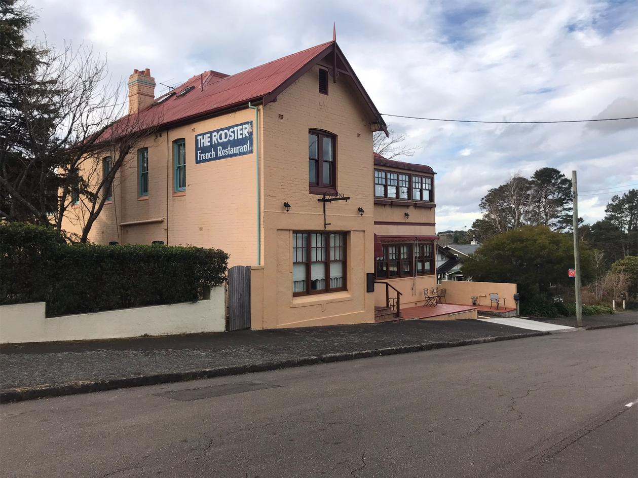
Blue Mountains Icon: ‘The Rooster’ has been yet another tourism business victim of NSW Government’s 4-year socio-economic lockdown regime (Nov 2019 – Nov 2022). [Photo by Steven Ridd, Tuesday 22nd July 2025]
So opposite The Rooster, there is a hiking track head to Prince Henry Cliff Walk off the side of the road junction across also from Carrington Park. This is the roadside signage:
References and Further Reading:
[1] ‘Leura Cascades landslip closure not a priority for council‘, 2020-12-31, by Steven Ridd, Tour Director, Nature Trail, on Mountains Drums blog, >https://naturetrail.com.au/blog-post/leura-cascades-landslip-closure-not-a-priority-for-council/