Leura Cascades landslip closure not a priority for Council
Yes it rains in the Blue Mountains. On average our region receives around metre of rain a year, but that’s a indicative statistical average – a simplistic calculation of total rain over so many years divided by the number of years since recorded.
In the Blue Mountains case for the Bureau of Meteorology (BOM) is just since 1994, or only the last 26 years.
Approaching a year ago, the Blue Mountains received a torrential downpour in early February (late summer). It does rain heavily in the Blue Mountains from time to time. The Blue Mountains typically receive about a metre of rainfall annually, generally during late summer.
Throughout the year, the prevailing rain comes from the south west as cold frontal systems off Australia’s southern ocean sweep eastward across the southern part of the continent. However, during the summer months, the Blue Mountains is impacted by east coast subtropical low pressure systems that come down from warmer coastal Queensland.
Occasionally, these low pressure systems become intense East Coast Lows formed out of ex-tropical cyclones, especially during the Pacific Ocean’s climate pattern known as La Niña, which occurs every decade or so. These move southwards slowly along the New South Wales east coastal regions and can remain more or less static for weeks at a time bringing widespread heavy rains, gales and causing flash flooding.
The BOM’s website shows that 2020, with more than 1.5 metres of rainfall, was well above the ‘average’ and more than double the rain of 2019 (a dry El Niño year). The closest was 1435 mm in 2007, not surprisingly being a wet La Niña year.
That weekend Katoomba’s weather station at Farnells Road recorded 259 mm of rainfall, which was backed up by Nature Trail base’s own 150mm capacity rain gauge filling up nearly twice. The deluge saw a total of 415 mm recorded at the Mt Boyce weather station from Thursday to Monday morning, including 158 mm on the Saturday and 137mm on the Sunday. By the Sunday afternoon, the rail track had been partially washed away along the ridge line above a steep embankment between Leura and Katoomba.
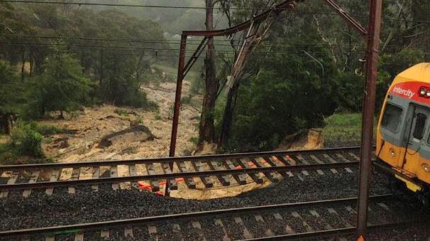 This is a repeat of what happened to the rail track at the base of Boddington Hill over a decade prior. [Photo by Paul Toole MP, NSW Minister for Regional Transport and Roads since April 2019].
Clearly the rail authority should employ a permanent hydrotechnical engineer to risk assess its stormwater infrastructure. Such infrastructure failures, like ‘trackwork’ at weekends, only serve to kill off tourism.
Both Council and the Parks Service reported flash flooding and flood debris along various watercourses and covering hiking tracks. Track infrastructure (footbridges) was damaged or washed away.
Significant landslips along watercourses and on embankments and over roads were reported, particularly near Leura Cascades Picnic Area, Charles Darwin Walk, Prince Henry Cliff Walk, Popes Glen and many other bushland locations throughout the Blue Mountains.
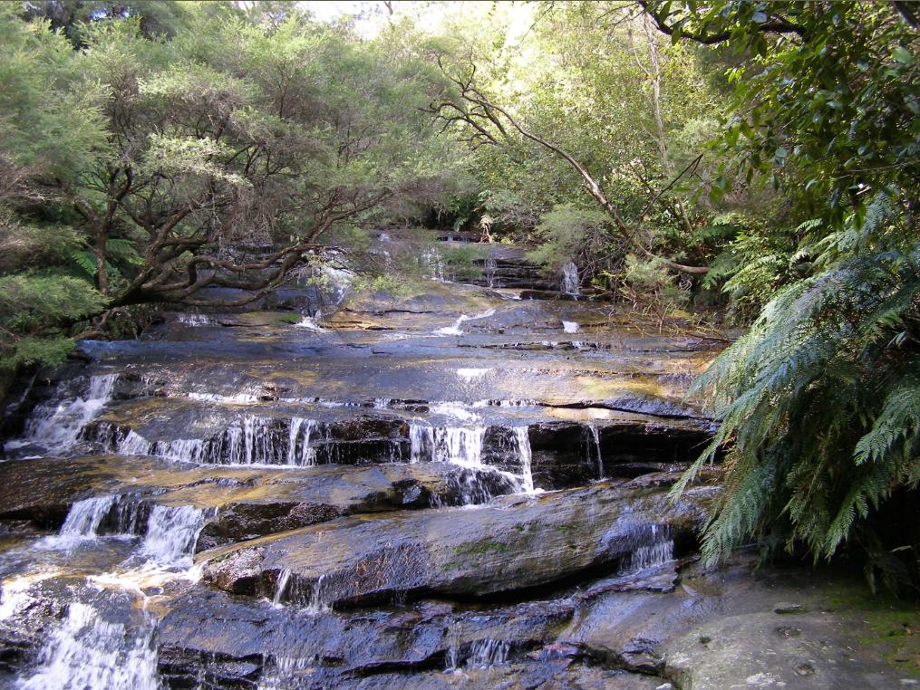
Leura Cascades Landslip
An enormous landslide occurred above Cliff Drive, sparked by the torrential rain in early February. It brought earth and rocks and trees tumbling down the slope, affecting more than 5,000 square metres of land, including Leura Cascades picnic area, nearby walking tracks and casting debris over a section of Cliff Drive.
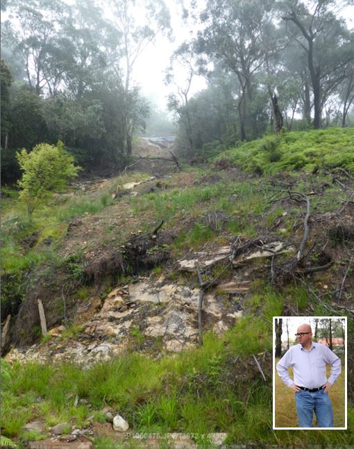 Stormwater infrastructure epic fail. This is the natural remediation with signs of new growth a year later. [Mayoral selfie inserted]
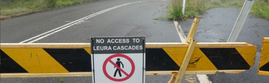
The popular tourist Cliff Drive atop the Jamison Escarpment between Merriwa Street in Katoomba and Jersey Avenue in Leura has been closed ever since.
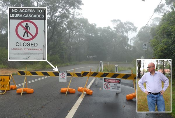 Nearly a year later, Cliff Drive and Leura Cascades Picnic Area remains “closed indefinitely” with no sign of remediation. [Mayoral selfie inserted]
Land owner Blue Mountains Council claims that because the embankment is unstable, geotechnical civil engineering works have been put on hold. Council attributes the landslip as a natural disaster, but was it?
The Cause of the Landslip?
One of the inspections council should consider is the absence of stormwater infrastructure at northern end of Govett Street immediately above the landslip. In a downpour, where is the runoff expected to go?
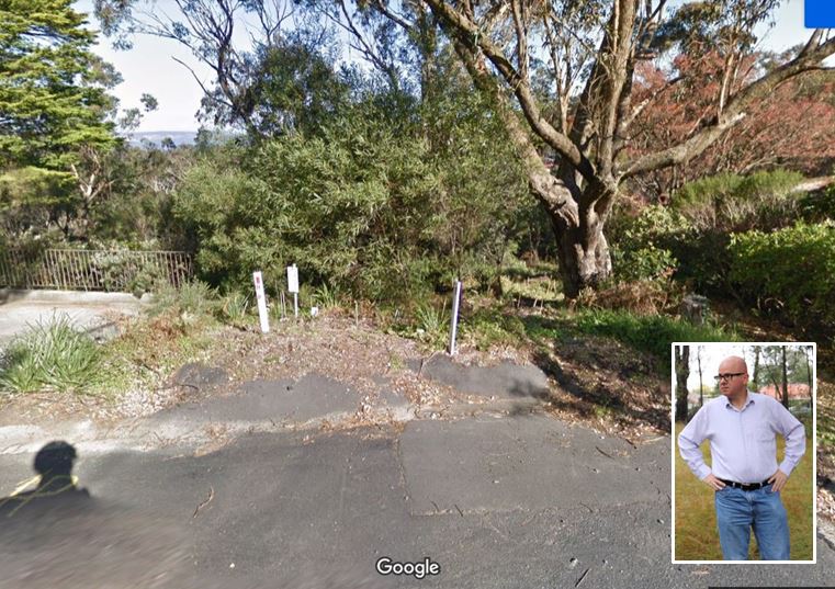 Council stormwater in Govett Street has nowhere to flow except down the embankment [Mayoral selfie inserted]
Any lay person could presume that during a downpour at this northern end of Govett Street, the street’s stormwater sheets fast over the impermeable bitumen road surface. It is downhill for over 100 metres from the hill crest at Cumberland Street into the bushland. Perhaps a great site for real adventure kayaking?
It was an upper Leura Cascades waiting to happen. Seems like the rail authority, Council boss Dr Rosemary Dillon should also employ a permanent hydrotechnical engineer to risk assess its stormwater infrastructure, including antique culverts and the two toxic tips upstream of local World Heritage.
Clearly, Leura Cascades landslip closure not a priority for Council. The repair bill is likely to exceed $500,000, but Council’s insurance will pay for it. The rail authority repairs the rail landslip in under three weeks.
But Council Mayor Mark Greenhill urges locals and tourists “to be patient”.
What? It’s been nearly a year Mr Mayor and Council’s inaction continues to prevent outdoor tourists from accessing the popular Leura Cascades and hiking along three very popular bush tracks of the Jamison Escarpment.
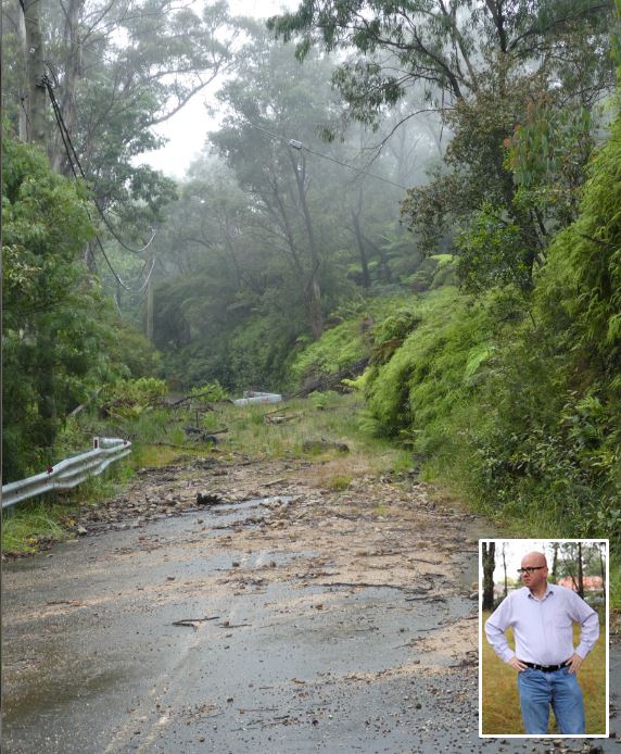 Cliff Drive at Leura Cascades, below the Govett Street steep embankment – nearly a year later. [Mayoral selfie inserted]
Such infrastructure failures left to endure just undermine the Blue Mountains tourist experience, as TripAdvisor tales account.
The popular nearby Solitary Restaurant has been forced to close as a compounded result of the road closure and the pandemic. These enforced closures come on top of the closures of many bushland reserves through the Blue Mountains (the Jamison Valley, the Grose Valley, Mount Victoria, Mount York) as a consequence of the bushfire damage and other unrepaired landslips.
Council says it will be seeking funding assistance from the State and Federal Government, but it is clearly not a priority for current Council Mayor Mark Greenhill.
 Leura Cascades have been closed to all access for nearly a year
Misguided Funding Priorities
Council’s current Strategic Priority Outcomes rank tourism lowly as its Priority 7 thus:“develop a strategic approach to tourism and the visitor economy that also addresses the increased visitation, local community and funding options.”
So much for Council’s guiding principle of sustainability that “its actions strengthen, and not erode, the condition of the natural, built and human capital supporting our quality of life.”
Instead of repairing these landslides, Mayor Greenhill has flagged in the local newspaper his more pressing priorities for Blue Mountains capital works, like those particular to his electoral Ward 4 in Blaxland.
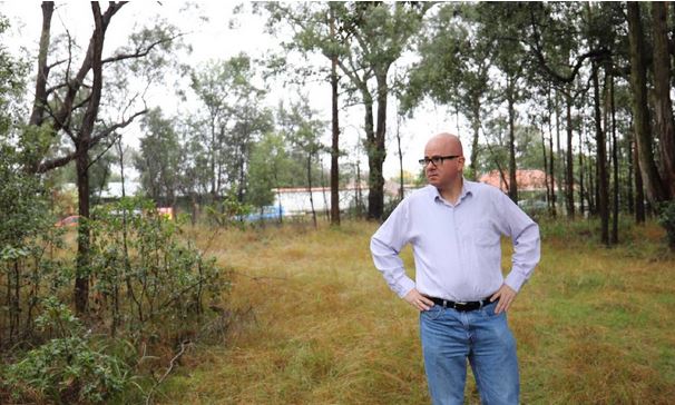
Since the February landslips, he’s instead approved funding for creating a Blaxland War Memorial Park, to spend tens of thousands of ratepayers money to upgrade what is essentially a narrow, noisy inaccessible verge.
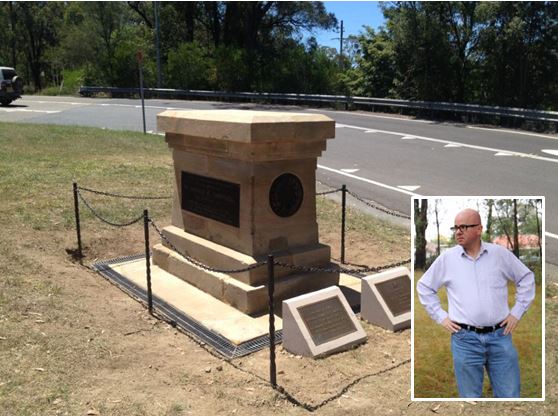
A shadow of its former self, place and meaning. Historical wrongs risked being repeated by disrespectful governments and their politicians. [Mayoral selfie inserted]
Mayor Greenhill thinks spending ratepayers money to re-design this isolated noisy narrow verge, to undertake do a pointless traffic study and an over-the-top plan of management will somehow attract pedestrians who will never use it.
This heritage memorial holds important local community value but it is in the wrong place. It is dedicated to a local hero, one Private Harold Kenneth Campbell who served with the AIF and died by gunshot wounds in 1916 (aged just 19) at Pozières in the Battle of the Somme during The Great War. Pvt Campbell is buried at Saint Sever Cemetery in Rouen in Normandy, France.
In 1925, as a permanent tribute, the Blaxland Progress Association was successful in having a Soldier’s Memorial erected as a permanent tribute to honour the Private Campbell. A sandstone pedestal was designed with an inscribed plaque and a captured German Maschinengewehr 08 machine gun mounted on top. Such a chilling reminder of the horror of war was similarly designed upon the entry of tourists to the historical gold mining town of Hill End out in the NSW Central Tablelands.
The memorial was positioned prominently near the railway station as a permanent reminder to rail passengers/commuters of the sacrifice of soldiers like Private Campbell. With around 200 people assembled for the unveiling, Councillor Wilson made a speech in which he said that it would “stand for ever as a beacon for the boys of the future to do their duty as the fallen hero had done his”.
However, over subsequent years and decades, ‘progressive’ government decisions disrespectful of this fallen hero and the Campbell family, saw the war memorial butchered of its machine gun relic and relocated to a desolate narrow verge inaccessibly wedged between the realigned highway and railway out of sight and out of mind. Over the years the plaques have been stolen for scrap cash.
All this was wrong, but Mayor Greenhill’s crazed notion of upgrading a desolate narrow noisy verge will only compound past wrong – the decision to remove the M-08 and the decision to relocate the memorial to a dumb spot.
 Mayor Greenhill knows how to waste money
As a community representative in a position of financial power, this councillor ought reflect on the historical context and rationale for the original siting of this important memorial. It was erected as a permanent tribute to honour the Private Campbell, to send a chilling reminder of the horror of war, and positioned prominently as a permanent reminder to rail passengers/commuters of the sacrifice of soldiers like Private Campbell…to “stand for ever as a beacon for the boys of the future to do their duty as the fallen hero had done his”.
However subsequent ‘progress’ saw realignment of the Great Western Highway in 1926 and the monument’s relocation away from Blaxland shopping precinct to an isolated verge. Again in the 1980s more ‘progress’ saw the realignment and construction Wilson Way Overbridge, and the killing the adjacent majestic ‘silent cop’ Turpentine tree at highway intersection with old Bridge Road.
A Council fixated on upholding wrongs imposed by governments of the past by notions of sanctifying an alienated noisy verge is to put lipstick on a pig. The sad wedged verge island across from so-called Blaxland Park is a dark stain on Blaxland’s relocated heritage.
A representative Council should consult with the knowledgeable custodians of local heritage, the Springwood Historians who have recommended the memorial’s more prominent public relocation back to being amongst the local community to Blaxland Mall (where commuters pass through daily – as was the local original intent).
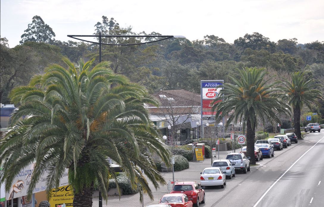 Surely that would cost much. Not as much as Councillor Greenhill’s dozen Canary Palms; over $100,000 was it?
Wasn’t siting this memorial in a prominent local position the original intent – that was to remind locals of the service and sacrifice by locals in times of war? The M-08 should also be reinstated on top so as to restore the memorial’s meaning and its heritage fabric.
Council should listen to the stated wishes of the surviving Campbell family, and to the input of residents and the local community of Blaxland, to local historians and to the Blaxland Chamber of Commerce, and not go off half-cocked wasting ratepayers money on extravagant projects.