Megalong Valley Closed
Below is the magical Megalong Road that takes one down into the ‘Megalong’…meaning “valley below the rock“.
When you arrive at the valley’s floor, you can then look back up to the escarpment and appreciate this naming by its ancient Aboriginal custodians.
This is Nature Trail’s treasured tour through Megalong Glen. It’s the inspiration for the namesake of our Blue Mountains tour operating business. It’s also why we chose our tour vehicle, as it features a sunroof to experience this very vertical rainforest and its cliff escarpments up through the open roof.
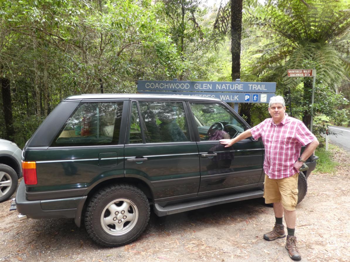
Our Tour Director, Steve with Excalibur.
For this particular reconnoitre trip to what we call ‘Megalong Glen‘ back on Friday 14th January 2022, Steve invited two local botanists along, each separately experts in Blue Mountains flora. It was to identify, document and map dozens of flora species in this Coachwood Glen Nature Trail (600 metre circuit) through temperate rainforest.
Afterwards, our small group collected our pre-paid lunch order from Megalong Tea Rooms of course, then headed off in ‘Excalibur’ in the valley to a favourite undisclosed picnic spot.
The field research took us three hours, plus many more by Steve writing it up for a tour plan and then further time field practising and tweaking the tour commentary. This combination drive-hiking day tour has become one of our special interest Coachwood Rainforest (Ceratopetalum apetalum) ecology hiking tours.
Nature Trail offers a variety of bespoke tours into the Megalong and into the wilderness beyond. So we take exception (like many) by now being denied road access into the Megalong and to earn a crust, indefinitely. This has all been caused by Council’s bureaucratic incompetence yet again. This seems to be underpinned by a public servant bubble ambivalent mentality,
So, we feel compelled to speak up about the Megalong’s landslip closure as we see fit.
Background to the rain event of 4th-5th April 2024
Last Thursday and Friday (4th and 5th April 2024), another intense East Coast Low weather pressure system impacted our Blue Mountains region.
It swept in from the Pacific Ocean to Far North Queensland and then extended southward down the extent of Australia’s Eastern Seaboard. This brought widespread heavy rains pushed southward through New South Wales into eastern Victoria. In New South Wales, the precipitation extended 1000 km inland to the Darling River in the NSW Far West region.
The public had been warned by the Bureau of Meteorology (BOM), albeit just a day prior:
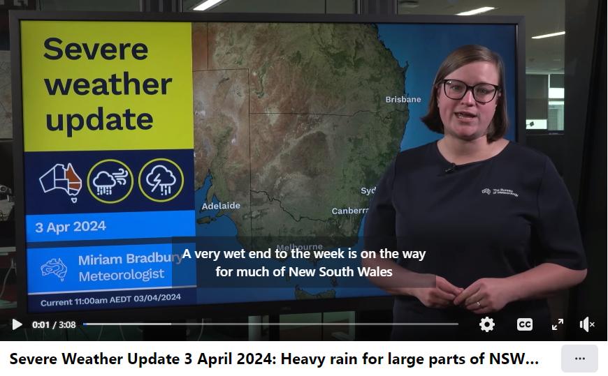
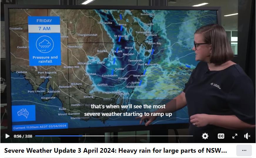
From our own Blue Mountains experience of this particular rain event, the heaviest deluge occurred during the Friday and intensified during that night.
At Nature Trail’s base in inner-west Katoomba, we emptied our full 150 mm rain gauge on Friday afternoon. Then that Friday night became torrential. By Saturday morning after the rain had cleared, our rain gauge had overflowed again. It was a heavy rain event; another one.
Katoomba’s weather station in nearby Farnells Road reported having received 230 mm over just those two days, which is a quarter of the Upper Blue Mountains average annual rainfall of 1050 mm. Usually, the Blue Mountain receives an average of around 1050mm per year while the Lower Blue Mountains receives around 850mm per year.
We suspect these are long-term avarages and don’t factor annual spikes featuring East Coast Low extended deluges like recently frequently during 2021 to 2023.
Here are the relevant rainfalls statistics for Katoomba sourced from the BOM for April 2024 up until yesterday; Katoomba being 4km east of the Megalong as the crow flies and rain falls, so all but similar for what the Megalong got:
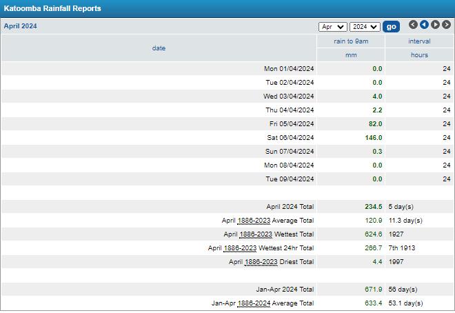
SOURCE: FarmOnline Weather, website ^https://www.farmonlineweather.com.au/station.jsp?lt=site&lc=63039&list=rb [Accessed 10th April 2024]
The Saturday rainfall spike was mainly after midnight Friday. The rain had cleared by daylight Saturday.
These two 24-hour days of constant rain would have provided good soaking for most farmers, dams, water reservoirs, rainforests and extending into the NSW Outback.
Indeed of late, drinking water catchment levels remain high after this La Niña periodic climate cycle again bringing increased rainfall across much of eastern Australia.
The East Coast Low weather phenomenon bringing widespread and constant deluge over days, weeks months of course has been the catalyst in all cases. But don’t blame God or the gods, or natural disaster excuse (unless it’s a council appeal for government relief and recovery funding) or some Climate Scientology ideology.
The BOM has records of La Niña events occurring throughout history along Australia’s Eastern Seaboard in the years: 1903, 1906, 1909, 1916-1918, 1924, 1928-1930, 1938, 1949-1951, 1954-1957, 1964, 1973-1976, 988, 1998-2001, 2007, 2009, 2010-2012, 2020, 2021, 2022 and now 2024. All this meaning that extended bouts of heavy rains are not uncommon for Australia’s Eastern Seaboard including Sydney and extending inland across our Blue Mountains region.
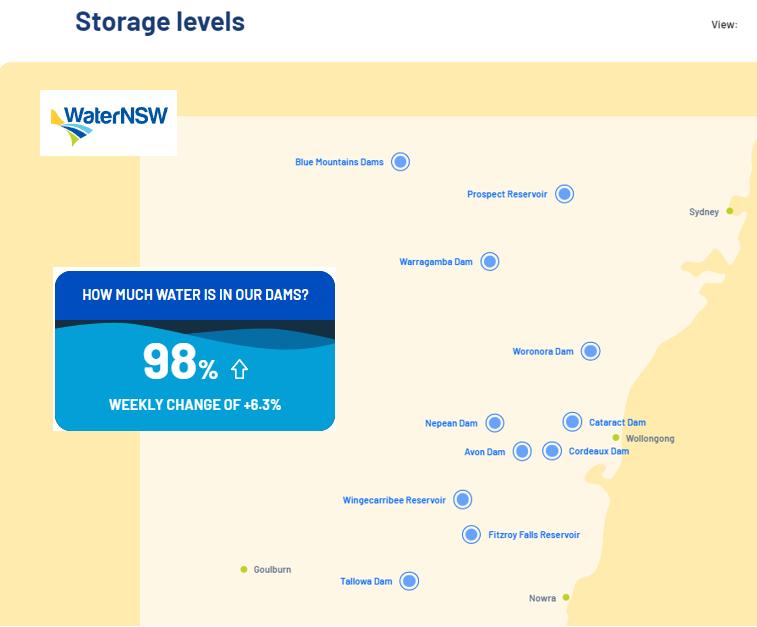
Currently, these are the drinking water catchment statistics for Greater Sydney and adjoining regions:
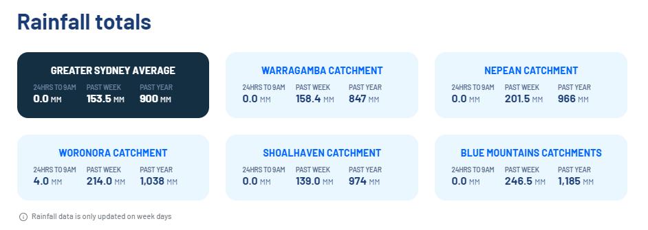
The combined drinking water storage currently sits at 98%, and that was before this latest rain event.
It’s not just the failings of the Blue Mountains Council to cope with historically recurring East Coast Lows in this sandstone plateaued river region. Adjoining councils are just as institutionally ‘plateaued’.
Throughout the Blue Mountains region, landslips are not a one-off occurrence; they’re a recurrence, usually after heavy constant rain over multiple days, weeks and in some cases months. Indeed, landslips are a recurrence in adjoining local government areas around the Blue Mountains – Lithgow, Oberon, Hawkesbury and Wollondilly.
Think about why so many ancient rivers dominate this Greater Blue Mountains region since 200 million years ago, give or take? The Nepean, Cox, McDonald, Kowmung, Colo, Wollondilly, Hawkesbury, Grose, Nattai, et al.
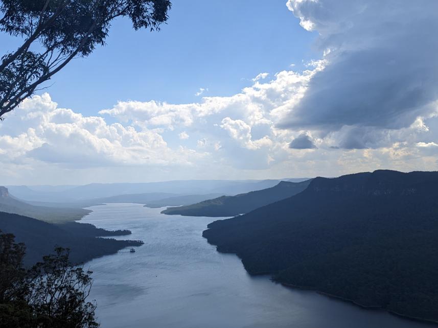
It’s why Warragamba Dam was built where it is in 1948 It’s why Lake Burragorang is currently full.
Megalong Community now suffering
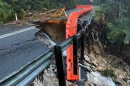
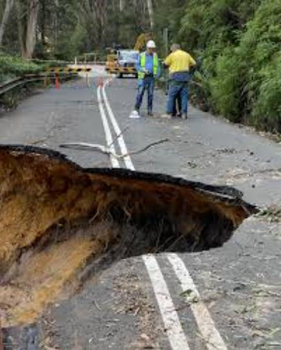
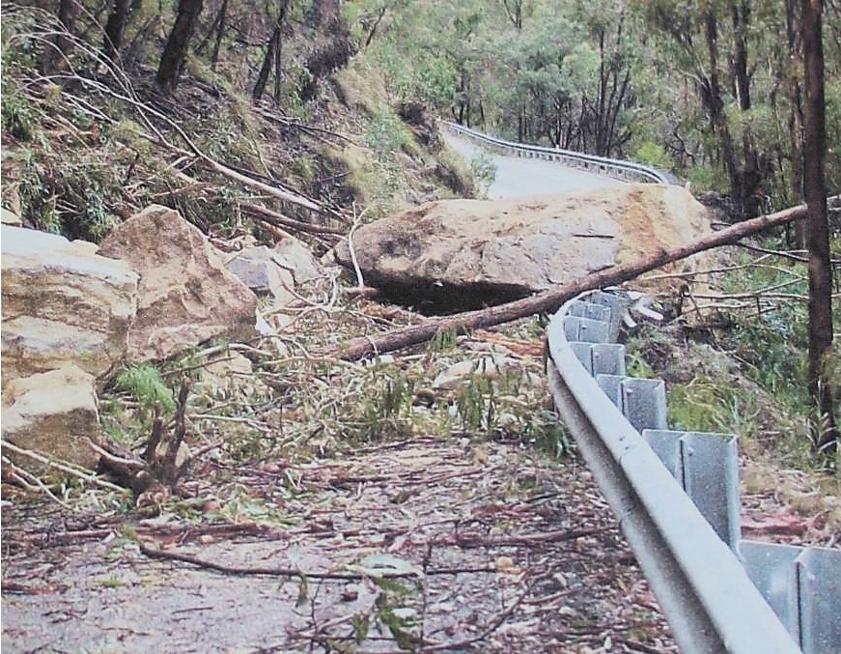
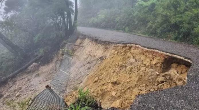
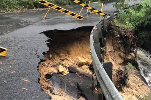
By the Friday evening, the Megalong Road, being the only public access road in and out of the valley, suffered a landslip collapse in the vulnerable upper steep gully section.

This upper part of Megalong Road, constructed atop Blue Mountains sand base, which has failed again in yet another section. It caused yet another landslide hazard and has resulted in indefinite road access closure into and out of the Megalong yet again.
As a direct consequence, Megalong Road in the Blue Mountains became immediately highly dangerous and impassable. This was realised officially by the Saturday Morning.
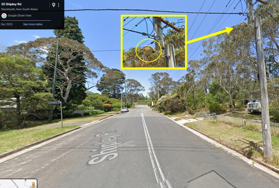
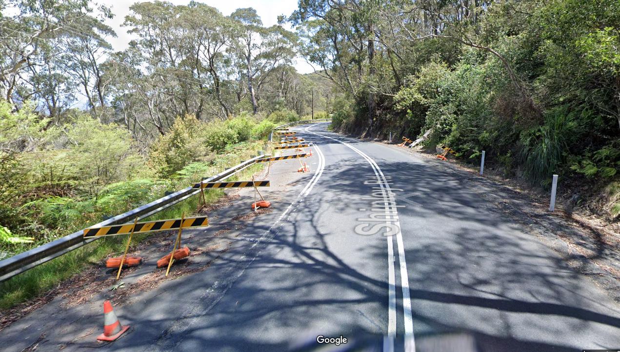
There are no street lights down Megalong Road. The last street light out of Blackheath is on Shipley Road still in Blackheath opposite the junction with Kundibar Street.
This means that at night there is a 9km driving distance in pitch black darkness from Kundibar Street to at least the Megalong Tea Rooms (that is if the Tea Rooms keep their private lights on when closed at night). Else the remainder of Megalong Road all the way south to the valley dead-end at Dunphys Campground (another 13km) is unlit.
[Note: We are not advocating the adding of street lighting along the Megalong Road. Rather we are advocating that the custodial ‘owner’ of Megalong Road (Blue Mountains Council) just fix it properly and A.S.A.P. Council needs to do the right thing by its ratepayers, especially those in desperate need. It needs to divert its increased budget since the Valuer General’s 2022 land valuation hikes and subsequent Council rates hikes, toward re-opening Megalong Road to all as number one priority for the Blue Mountains LGA.]
Immediately adversely affected by this current landslip are the local folk of the Megalong downhill of this latest landslip. This means all the valley’s residents, businesses, workers, school pupils, delivery operators including affected tour operators, yes like Nature Trail, and many others.
This comprises a small scattered rural community throughout this valley numbering about two hundred or so. There are more than 40 businesses in the valley totally dependent on these roads – businesses over recent years have been drastically affected.
Unlike what the media report, Megalong cannot be characterised as “a small town”. No, it’s a small rural valley with a few small hamlets at best. It’s pretty much comparable to Wolgan Valley in more ways than one. The catastrophic impact (revenue and extra costs) on every other business and worker in the valley will be similar.
Media reports haven’t factored in all the other people dependent on accessing the valley, nor those dependent on valley folk travelling out of the valley on a regular basis for food, shop, work, school, medical needs, vets, car repairs and other essentials and the basics of life.
In the Megalong, there are no shops, retail, medical centres or typical town services.
Media lies, damn lies and statistics, eh?
Yes, there’s famous Megalong Tea Rooms, but it’s a tourist focused eatery. It won’t be able to trade or get staff for the foreseeable future, that is unless Council pulls its finger out pronto.
Since that fateful Friday night, many became trapped (including dozens of trapped visitors) either in the valley or from it, due to no fault of their own.
This is not the first time that landslips have plagued this access road. So once again, the many folks who live, work and visit the Megalong are catastrophically affected by being cut-off from society and denied basics for life support, the normalities for everyday living and for earning an income.
Blue Mountains Council is legally responsible for the maintenance of Megalong Road. It has failed again to be proactive in this regard.
So Blue Mountains Council, for how long this time?
Blue Mountains Council is legally responsible for the civil works remediation of this landslip collapse of Megalong Road. Council needs to take leadership, rather again in its disastrous previous landslip remediation ‘Landslip #1‘ delegated out to incompetent civil contractors outsourced from Sydney.
So the NSW Government has decided to declare Council’s ‘Landslip 1A‘ a natural disaster. However, the fine print reads of limited support being only “for eligible residents to help meet immediate needs as follows:
- Emergency accommodation
- Small cash payments to purchase essential items generally provided from evacuation or recovery centres
- Replace lost essential household items to maintain basic standard of living
- Essential structural repairs to restore their homes to a safe and habitable condition.
- Freight subsidies for primary producers to help transport livestock and fodder.
- (Bloody government) LOANS? for impacted small businesses, primary producers, sporting and recreation clubs, and non-profit organisations to repair or replace damaged or destroyed property.
But governmental financial support is NOT being offered for lost income that businesses and worker will never get back while Megalong Road is closed.
This despite the landslip being due to Councils fault through systemic neglect of this road’s known landslip risk. Council knew about the risk of its ‘Landslip 1A’ (on this Council road) back in 2021, but did diddly-squat to address the risk.
Megalong Road Profile
Megalong Glen – the upper 5km section of Megalong Road through intact ancient temperate rainforest – a tourist destination
“The name ‘Megalong’ is of Aboriginal origin, said to mean roughly “valley under the rock”. The valley, first surveyed in 1838, was settled long before the railway crossed the Blue Mountains, the pioneers travelling up from the districts of Burragorang and Camden.
In the 1880s, with the opening of the Six Foot Bridle Track from Katoomba to Jenolan Caves and the development of kerosene shale mining, the population at the Katoomba end of the valley increased and a small mining township grew up at the base of Nellie’s Glen.
When the Megalong Valley Road opened in 1897 and mining operations began to peter out, the orientation of the valley community shifted to Blackheath.”
SOURCE: ASK ROZ website, https://www.askroz.com.au/blog/Q&A/what-is-the-history-of-megalong-valley-8506/
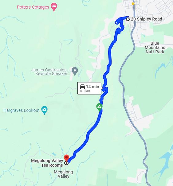
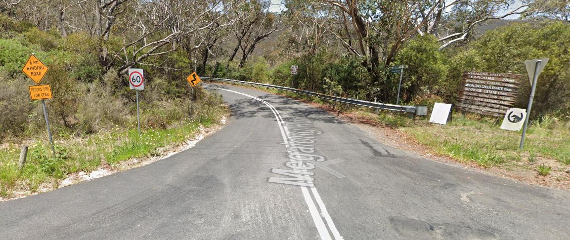
Megalong Road is the only public access road from the Blue Mountains plateaued atop from Blackheath’s Shipley Road (altitude ~1065m) off the western escarpment.
Its route descends down into the otherwise dead-end Megalong valley floor (altitude ~ 578m). The overall length of Megalong Road is 23 km from north to south commencing from the ridgeline junction at Shipley Road just outside the town of Blackheath and finishing at the valley’s dead-end at Dunphys Camping Ground.
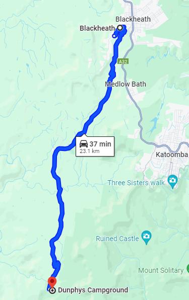
The famously popular Megalong Tea Rooms are situated along Megalong Road on the valley floor about 8 km south of the north junction on the corner of Peach Tree Road.
The hamlet of Megalong itself is 16 km south of that junction along the valley floor, featuring just a primary school, church and a few dwellings. So, the Megalong it is not what the media report as being a “town”.
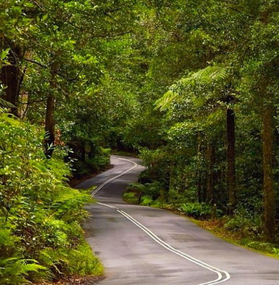
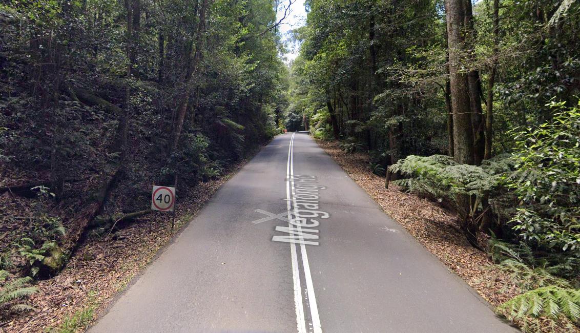
This upper entry rainforested section of Megalong Road descends about 500m elevation over a narrow winding 5km road distance pretty much to the Blackheath Glen Reserve. The safe drive ought to take a safe 20 minutes, but from experience, delinquent hoons dangerously regularly race far faster with impunity.
Megalong Road in its upper section, handrails (follows parallel to…) Pulpit Hill Creek in a southerly direction winding its way downhill through a rainforested ‘cleuch’ (Scottish for ‘small steep valley’) over a 5km distance down to the valley floor of Megalong to Blackheath Glen Reserve and beyond.
This particular upper section of Megalong Road is problematic by its:
- Passing through steep narrow topography
- The narrowness of the road
- The windiness of the road at the top section
- The absence of any lighting through a dense rainforested narrow valley
- The area’s regular high rainfall
- The road’s poor structural integrity, a thin bitumen paced surface
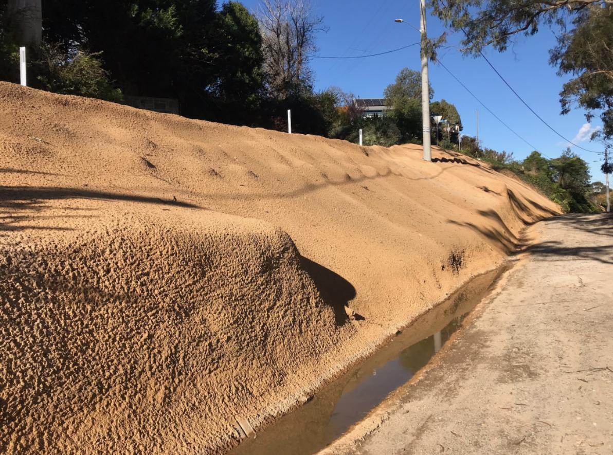
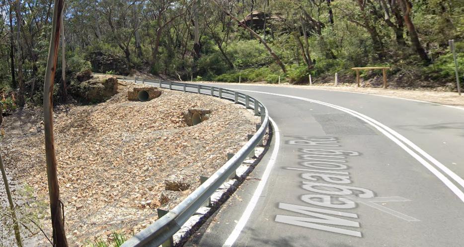
- The road’s paving atop a sandy porous substrate (see image below)
- No road shoulders
- The road being cut into steep sloping terrain
- The road’s traversing multiple watercourses, but lacking suitable drainage below
- Increasing heavy traffic and heavy vehicles – mainly many more trucks.
It is a local rural road, not designed for heavy traffic. Essentially, Megalong Road was poorly constructed from its historical colonial origins. In many sections the road lacks provision for natural watercourse and ground water drainage underneath it.
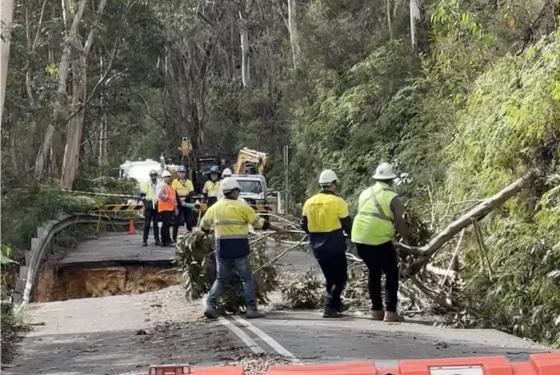
Consequently this happened last Friday:
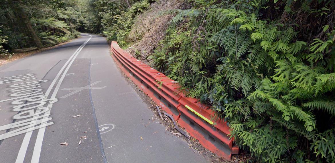
Council Diddly-Squat: During rain, groundwater from higher ground flows downhill. It’s called gravity. Sand substrate facilitates this whether a road pavement is in the way or not. When the rain is heavy, then there is more groundwater that has to go somewhere.
Megalong Road’s asphalt pavement is relatively thin (just 10cm). It’s hotmix asphalt has been laid (and re-laid) atop a sandy substrate as can be seen in the above photo. This sandy layer is quite deep and rests above a sandstone bedrock below.
During times of heavy rain, the ground water build up flows from the steep hillside downhill across and under the road through the sand. Note the absence of pipe drainage or a culvert.
The presence of an ancient temperate rainforest dominating the northern upper gully section (a 5km road distance) provides a thin loam top surface layer. The tree root systems helps stabilise the otherwise sandy soils. The forest ecology through this gully continues to be fraught by such disturbance having a road originally bulldozed through it.
The integrity of this Megalong Glen upper section of Megalong Road continues to be fraught by its poor build. The historical road was initially only to serve access to a few local pastoralists, not intended for daily heavy traffic.
Council’s emergency response thus far…
Immediately Securing the Landslip Site
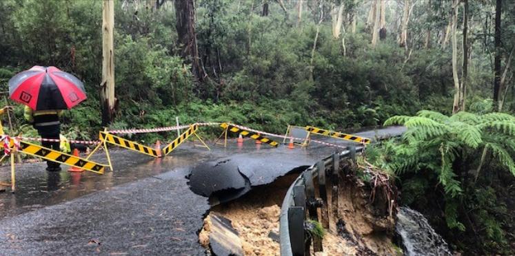
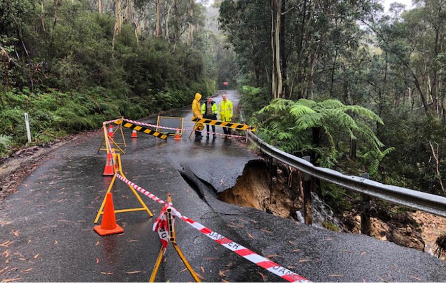
The first course of action was for Blue Mountains Council to close the road and secure the landslip to prevent it getting worse.
Blue Mountains Council workers on site, but the following Monday. What response was despatched over the intervening weekend?
Temporary remediation – Landslip 1A in April 2024. The road remains impassable for months.
Emergency supplies to those trapped in the valley
Otherwise, it seems that government default emergency response has been to delegate it to volunteer outfits again, as is par for the course.
A largely volunteer NSW Rural Fire Service (RFS) has been seconded by government to supply emergency supplies to Megalong stranded folk via air shuttle using the RFS helicopter.
Good on the volunteers for stepping up, but it’s not good on the government responsible for the neglect of the road and for the emergency response and recovery efforts.
As an aside, isn’t the RFS tasked to put our bushfires? Politicians shun the concept of Australia having its own standby National Guard equivalent on standby for such civil emergencies, fully paid and funded by us taxpayers of course. Government default response is to second unpaid volunteers, so that the indulgent pet projects of the politicians don’t get postponed or cancelled.
It’s encouraging to read that the Megalong community is rallying together to provide support and assistance – unpaid volunteers of course chipping in.
Food fuel and emergency supplies are currently being distributed at the Megalong Tearooms. Manager Dice O’Neill said that the tearooms have transformed into a central community hub since the landslip.

The RFS gently loads emergency supplies at Katoomba Falls Reserve oval, before shuttling into the Megalong.
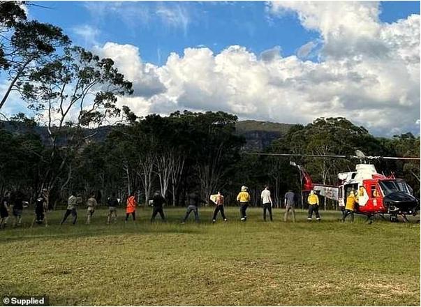
Megalong volunteers unload the helicopter
The community have banded together to support one another during the testing time.
Megalong Valley Tea Rooms has become ‘a bit of a community hub’ as the variety of airdropped items and foods were delivered to the cafe for residents to collect.

Megalong Tearooms facilitates distribution storage for emergency supplies (from Katoomba’s Woolworths & Todarellos Fruit Market?)
Mr Dice O’Neill:
“This is sort of a place where people can come and grab a cup, have a bit of a yarn with everybody, get a sense of normalcy and also find out what’s happening. We’ve just got the community coming in and grabbing what they need when they need it, and everyone’s been pretty good about it. Residents could potentially see the construction of a temporary new road within a matter of days.“

Megalong Tearooms putting a local community get-together a week on from the landslide Friday 12th April 2024
Check out their Facebook page: https://www.facebook.com/Themegalongvalleytearooms/
‘Plan B’ valley access
With the thankful co-operation of key local rural property owners, 190 residents and visitors managed to evacuate under police escort through a private property and unlocked gates on the Sunday night, aided by a bulldozer that cleared a path.
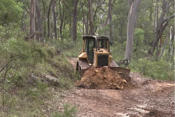
According to media reports, a Megalong bulldozer owner had to carve a new section of track through bushland so as to fashion an alternative temporary road route out of the Megalong.
So, at least someone quickly came up with a workable evacuation route Plan B. Well done! Locals looking after locals.
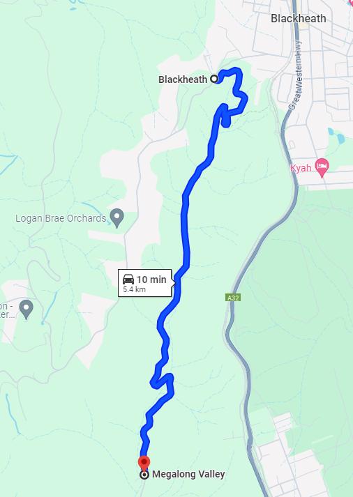
Currently checking Google Maps, the directions between the Shipley Junction and Megalong Tea Rooms auto-switch to the following access road ‘Plan B’.
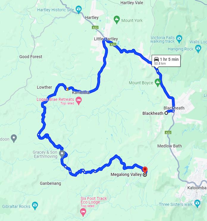
This is the current Megalong access road ‘Plan B’.
Someone must have quickly told Google about this, but now 50km each way on a back road?
But we seriously doubt the indicated travel time shown by Google. This is due to the back road conditions demanding a much slower average speed likely 40 kph (even before more rain). The likely road travel time from the Tea Rooms to Little Hartley (37 km) would be at least an hour alone.
It is likely that Megalong locals may switch from shopping in Katoomba (currently 60km from the Tea Rooms by route Plan B) to instead shopping in Lithgow driving via McKanes Falls Road (48km from the Tea Rooms) for the time being. This is made possible since the McKanes Falls Bridge over the Cox River re-opened on 30th November 2022.
Whereas normally between the Shipley Road junction to the Tea Rooms is just 9 km (a safe 20 minutes under the speed limit (not 14 minutes) and pretty much directly from Blackheath.
At least this ‘Plan B’ has been made road access in and out of the Megalong for locals and their deliveries. But for the more discretionary tourist trade, this considerably longer route Plan will likely deter visitation into the Megalong.
The implications for loss of revenue by Megalong businesses and their staff who drive in will be considerable.
Blue Mountains Mayor Mark Greenhill, estimates the remediation delay to take up to four months to re-open:
“repairing the landslip on Megalong Road could take between three to four months, restoring the road to its usual condition…and a long-term solution would involve constructing an additional route to ensure that the town is not cut off during a natural disaster. That’s a much bigger project for our small council, and we would have to engage with colleagues in higher government.”
SOURCE: ‘Landslide destroys Megalong Valley road, leaving Blue Mountains community stranded’, 9th April by Freddy Pawle, Daily Mail Australia.
Council Financial Compensation (no loans, no audits)
Whilst this mess is going on, all Megalong folk deserve full financial compensation by Blue Mountains Council, including essential livelihood support, and the provision of a safe alternative road route out to access essential services – foodstuffs, health care, work, and all essentials to sustain their livelihood.
We are aware of the many individual small businesses impacted.
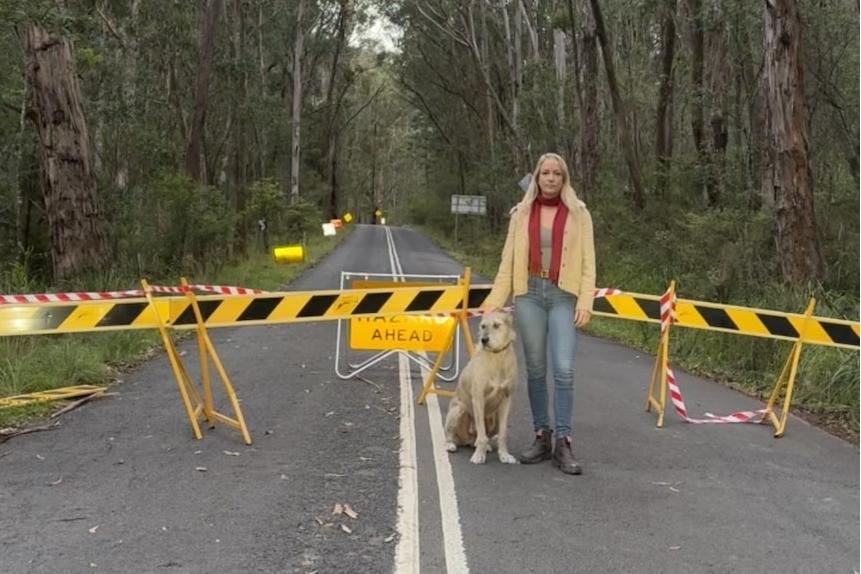
Megalong local Claudia Abbott with her dog. Megalong locals again isolated and trapped again by another road landslip closure, denying their only access by Megalong Road. It’s a recurring failure of the poor standard of this only access road in 2021, 2022, 2023, and again now in 2024, and many years prior. [Photo: Megalong Valley resident Claudia Abbott]
We celebrate your leadership, Claudia.
Businesses facing tens of thousands of dollars’ worth of revenue loss have called for greater financial support. Council neglected Landslip 1A and now Megalong businesses and workers are paying the price. It is incumbent upon Council to compensates for the losses in business income that it has directly caused. And not like token coins tossed in a well.
Many business owners were only just starting to get back on their feet after the last landslide closure in 2021. Megalong Road has never been repaired completely.
The owner of a local vineyard and wedding venue, Emma MacMahon, said she was unsure how much the loss of access would cost her business. However, she said the financial implications would be significant for the region if the road could not be reopened shortly.
Ms MacMahon employs 22 people at the venue and is in the process of re-homing half a dozen weddings that had been booked at the vineyard.
“We usually have hundreds of guests at the cellar door every weekend … so losing hundreds and hundreds of visitors every week is financially enormous,” she said.
She said she was at a loss as to what to do with her employees.
“We are coming into our busy time of the cellar door with autumn and I don’t know what will happen with the staff. I would hope these is some kind of government assistance but we can’t employ people if we don’t have customers.”
Workers are unable to get to their jobs in or out of the valley. Megalong businesses down there that are unable to get customers in.
Ms MacMahon said it was crucial another road into the community was built given the recent closures.
Disaster funding has been released for the Blue Mountains shire, with eligible residents able to apply for grants to replace essential household items and fix structural problems with their homes.
But can we trust the government not to decide to later audit the recipients years on, just like NSW Government’s done with its Indian Giving pandemic Micro Business Grant of 2021?
COMMUNITY QUESTION: When will Blue Mountains Council re-open Megalong Road to restore public access into the Megalong?
And all this trauma repetition! This comes after the NSW Government’s late 2019 bushfire catastrophe, the NSW and federal government’s 2020-2021 mandatory pandemic lockdowns, the 2022-2022 recurring torrential East Coast Lows, and otherwise abandonment of local business across this Blue Mountains region!
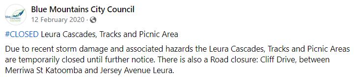
Recall that Blue Mountains Council was wholly culpable of its poor stormwater infrastructure which caused the road landslip closure of Leura Cascades back in 2020.
Squarely identified as the cause was Council’s dodgy stormwater open pipe from Grose Street above cheaply designed to continually flood stormwater over and down the steep bushland embankment to Leura Cascades access road that singularly caused this tragedy into Leura Cascades picnic area below:
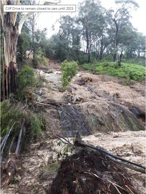
Council Diddly-Squat: Despite Council’s promises, the popular Leura Cascades tourist picnic area was NOT restored in 2023. Leura Cascades still remains closed some 4 years later.
So don’t hold your breath for Council’s restoration of Megalong Road any time soon.
No lessons learned from the Wolgan Road landslips
Megalong Valley locals could consider this a copy-cat isolation tragedy copped by their ‘sister’ regional neighbours in Lithgow’s Wolgan Valley, situated 60km to their north.
It compares in this regard with similarly ‘dead-end’ Wolgan Valley also in the Blue Mountains region.
Council Diddly-Squat: Lithgow Council’s Wolgan Road closed since 9th November 2022 due to heavy rain induced landslip, locking off dead-end Wolgan Valley to its residents, businesses and their livelihoods.
Read More on this one:
Emirates Wolgan Valley Resort obviously didn’t do due diligence on Lithgow {city} Council risk
Read even more about the locals’ Wolgan Valley Association:

With no certain timeframe, Megalong and connected businesses cannot plan what to do, so are being left in the lurch, just like how local Wolgan Valley businesses have recently copped comparable critical access road maintenance neglect from nearby Lithgow Council.
Megalong Road ‘Landslip 1’ of 21st March 2021
It’s not Megalong Road’s first landslip and it won’t be the last, given the poor quality of this road.
Following drought then the catastrophic wildfires that the NSW Government allowed to incinerate 80% of the Greater Blue Mountains Area (October 2019 to February 2020), it was another torrential East Coast Low event that ended up extinguishing the fires on 10 February 2020.
Between 4th February 2020, a large high-pressure system over the Tasman Sea sent moisture-laden easterly winds toward eastern Australia and a surface trough over central Queensland and New South Wales. By 7th February the trough had intensified and by 7th February it had developed into an East Coast Low bringing torrential rainfall and flash flooding.
This rain impacted Megalong Road with many new potholes and damage to the road edges at various sections. Note that there are no road shoulders along Megalong Road. The asphalt butts up to the forest, which in another sense is part of the road’s enchanting charm.
One of a dozen or so resurfacing ‘Jetpatch’ repairs to various Megalong Road potholes due to heavy rain, thin paving and the heavy weight of increased truck movements
The preservation of the ecology of this upper glen section of Megalong Road is paramount.
No, we do NOT advocate ‘shot-creting’ the sides of the road like what Council’s recently did to Lower Wells Street in The Gully in Katoomba.
The antithesis of streetscape aesthetic amenity:
Council’s shocka ‘shot-creting’ of a bushland embankment dividing Upper Wells Street from Lower Wells Street in the Gully in Katoomba. Council has managed to make this street now the most fugliest in the Blue Mountains.
Further heavy rain associated with repeated East Coast Low events recurred during 2021, 2022 and 2023.
After Council’s ‘Landslip #1‘ of March 2021, The Megalong community was cut off for seven days. Council organised an hourly 13-seat commercial shuttle bus from the Megalong to the Carrington Hotel in Katoomba and back between 9am and 3:30pm so that locals could shop for essentials and get medical services and supplies.
Council arranged next day supermarket supplies to be delivered to Megalong Rural Fire Brigade station near the Tea Rooms via online order with Coles in Katoomba using the address of 52 Shipley Road Blackheath (Blackheath Glen Reserve).
It took several weeks before full access was restored.
In April 2022 there was a landslip demanding full road closure of Megalong Road to remove a fallen tree over the road on Tuesday, 26 April 2022. By 5th July 2022 the NSW Government declared a state of natural disaster for dozens of local government areas after torrential rain and major flooding.
Council Diddly-Squat: Council’s ‘Landslip #9’ neglected further downhill before Coachwood Glen
Between 9th and 11th October 2022 Megalong Road was closed for essential roadworks for three nights denying access to the Valley.
On 28th March 2023, Blue Mountains Council’s business paper reported 67 landslips in the Blue Mountains arising from four natural disaster declarations since March 2021, Megalong Road having the most landslips numbering twenty four and nearby Kanimbla Drive through the adjacent Kanimbla Valley to the north having the second most slips numbering eighteen.
Council Diddly-Squat: Council’s ‘Landslip #9A’ neglected even further downhill before Coachwood Glen
So, what happened to Landslips #2, 3, 4, 5, 6, 7, 8?
Council approved a proposed $76 million Landslip Recovery Programme to be fully funded by the state and federal governments to remediate problem sites throughout the Mountains, planned to be spent over three financial years.
Yet by April 2024 Council had only around $6 million for the valley since Megalong Road was first shut in 2021. So what’s happened to Council’s other $70 million? Consolidated revenue?
Here’s another landslip along Megalong Road. We are losing count.
Council Diddly-Squat
Back in March 2021, 100 metres uphill of the current April 2024 landslip, a previous landslip occurred where this road traversed an upstream tributary of Pulpit Hill Creek as the road rounded the contour of the steep gully.
These are the 2021 photos:
Council’s Landslip #1 on Megalong Road of 21 March 2021
This same Council ‘Landslip 1‘ shown subsequently remediated by Council contractors by 2023.
Finally at Council’s ‘Landslip #1’ this time Council sensibly decided to install drainage piping under this road, given that is traverses a natural watercourse. And a crash barrier, and even a wee horse tie up railing?
However, Council recorded problems with its civil works contractor in its ‘Megalong Valley – Natural Disaster Recovery Update – November 2023‘ as follows:
“The landslip works at Megalong ‘Landslip #1’ was not satisfactory and took a long time to get completed and had no council supervision. This should not be repeated for rest of the landslip sites remediation.”
[SOURCE: ^https://www.bmcc.nsw.gov.au/major-projects/megalong-valley]
Megalong Road ‘Landslip 1A’ of 9th April 2024
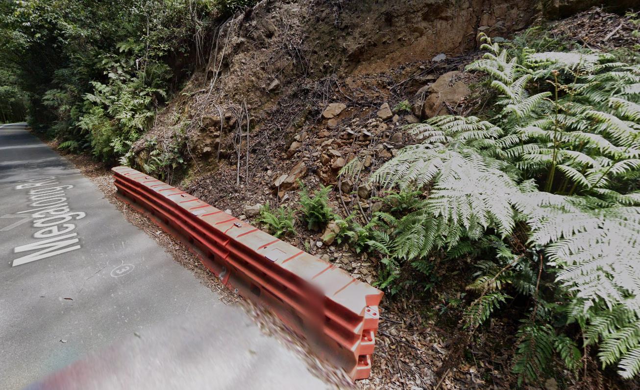
Just 100 meters downhill from the above landslip, this was the same section of road for years prior.
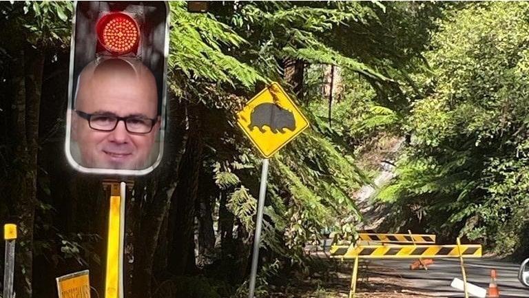
Council had installed a cheap temporary fix by crash barriers and an el cheapo fix ‘give way’ sign left by Council, but no ‘stop and go’ automatic traffic lights. Dangerous at night being unlit, especially for non-locals in the pitch blackness.
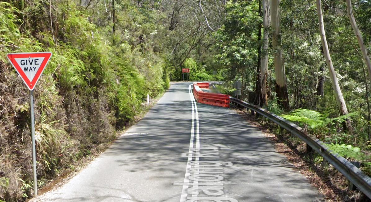
Council’s Landslip #1A’ – Diddly-Squat since 2021
Close up:
Megalong ‘Landslip 1A’ before 9 April 2024, since way back in 2021. Nice one Council.
Blue Mountains Council had long known about this particular landslip risk.
Of note in this Google Maps ‘street view’ photo above, large native Eucalypt trees (on the downhill side) have been killed down to stumps.
Given this is Council custodial land, the trees would have been chainsawed by Council. Why? Who knows? But they clearly were not replaced with similar locally native species. This has meant that the dead tree roots rotted, so leaving no vegetation to bind the soil to stabilise the immediate slope beside the road. This inaction exacerbated the landslip risk.
Blue Mountains Council had long identified this “possible new slip” section. An extract of its November 2023 report:
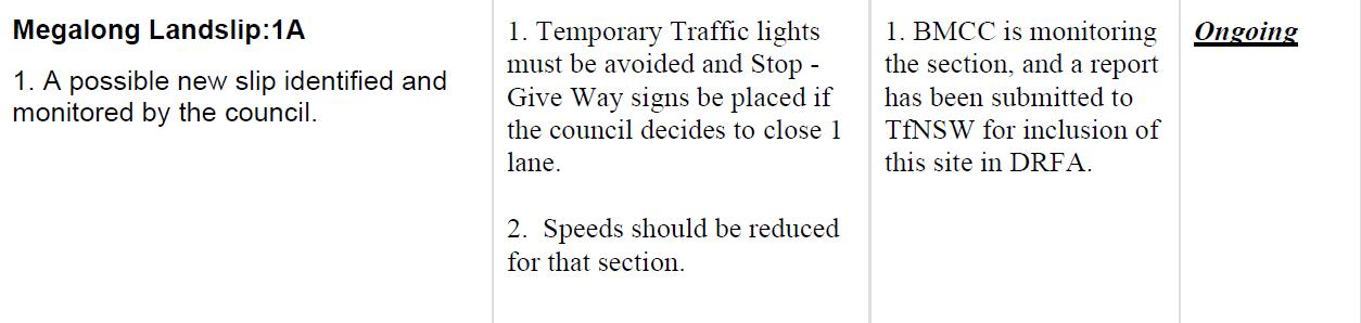
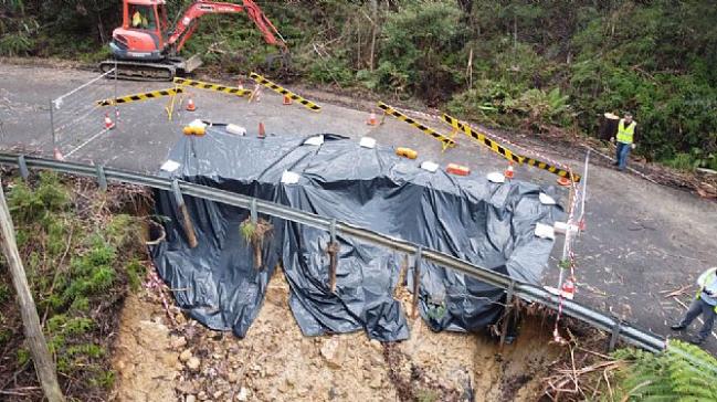
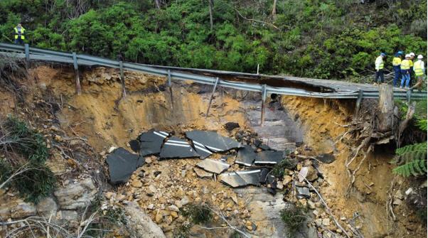
The location of the current 5 April 2024 landslip (‘Landslip #1A’) is about 600m downhill from the Shipley Road junction. The landslip has now made Megalong Road impassable as the following photo reveals.
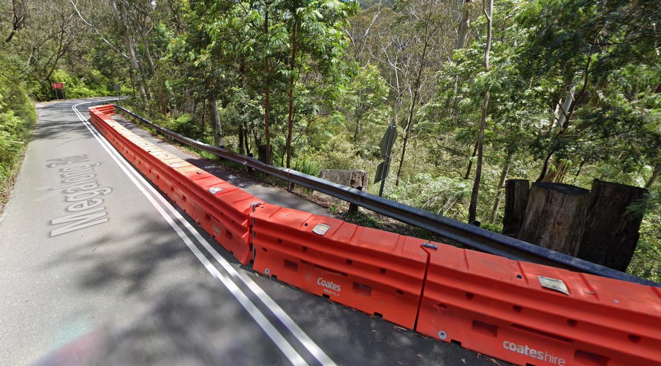
Recognise this crash barrier below? Same colour. Same same.
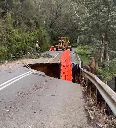
WOOPS: Soon after the rain, Council despatched its civil works crew to remove council’s ‘temporary’ crash barrier, since it was not a good look for council.
Council quickly removed the evidence of its long neglect of not remediating this section of the road that had shown signs of water damage many months prior.
Red crash barrier gone – not needed now
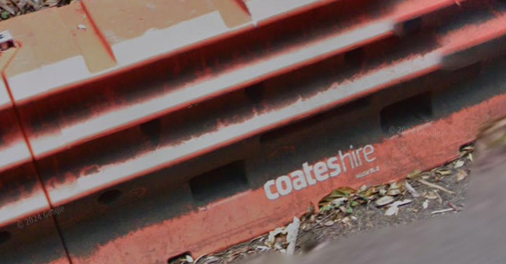
Note that Council hires these crash barriers from Coates Hire for years at a time. But at what annual wasted cost to ratepayers? It’s not Council’s money, so why should they care?
Why does Council not be frugal and instead buy a hundred and have them on hand. It would be far cheaper than hiring the things indefinitely and more convenient when urgently needed.
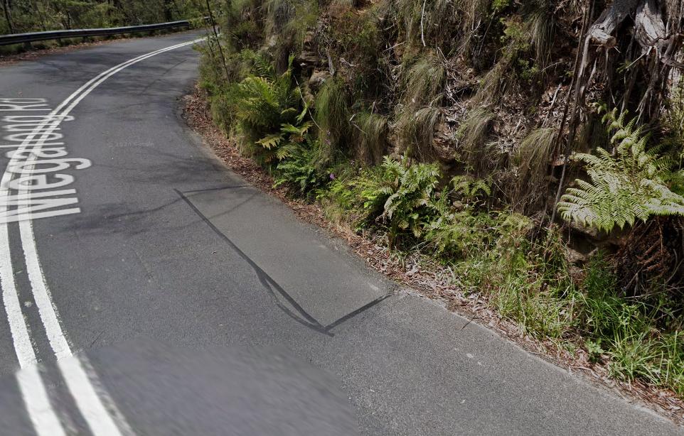
The exact location of Council’s ‘Landslip 1A‘ is 100m downhill of Council’s previous ‘Landslip #1‘ along Megalong Road. That location is over the beginnings of a natural watercourse, yet there had been no drainage infrastructure constructed underneath that section of the road despite it traversing a small upper gully.
Council had that first landslip geotechnically and hydrologically stabilised and rehabilitated back in 2021.
This is an extract from Google Maps of this upper section of Megalong Road below the junction at Shipley Road.
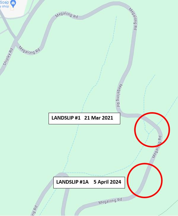
Twin landslips within 100m of each other from 2021. #1 fixed, but #2 neglected – now Megalong Road is closed again indefinitely in 2024.
Council abandoned its ‘Landslip #1A‘ for years. Now it’s become another road closure disaster for all to use and rely upon Megalong Road to live and work their lives.
This latest disaster confirms a systemic failure by Blue Mountains Council’s road making to adequately assess the geotechnical and hydrological landscape risks of its road network and to factor in its known seasonal heavy rainfall characteristics within the Blue Mountains.
Council’s engineering appears quite out of its depth. In the Blue Mountains sandstone plateaued landscape, the hydrological risks are acute. Yet this naive and unqualified Blue Mountains Council management does not employ an expert hydrologists nor geotechnical engineers.
Nor does NSW Parks Service (NPWS).
Is it any wonder then why such landslips throughout the Blue Mountains region keep recurring?
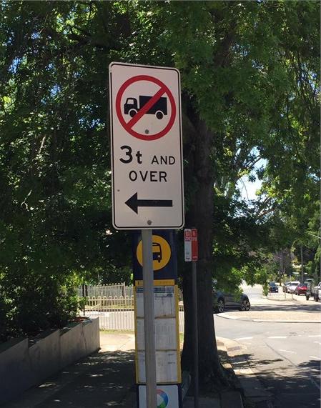
Megalong Road Not Suitable for Heavy Trucks and Buses
Megalong Road was not designed nor constructed to take heavy trucks, nor a regular high traffic volume of them.
Until Council invests in making Megalong Road suitable for heavy trucks over 3 tonne, it should proactively install the following 3 tonne weight limit sign at the Shipley Road junction, as well as a strategically positioned 24/7 CCTV back to-base (Council) camera to enable fines for transgressors.
Also, half a dozen hidden speed cameras along Megalong Road wouldn’t go astray either, given the speed limit is sensibly 60 kph along the winding road sections, and given that many motorists constantly exceed these posted safety speed limits.
The limit is even down to 40 kph at problematic sections.
Hey, the fine revenue, if correctly channelled only to this road’s maintenance, would help fund the road’s long overdue remediation!
Council’s Budget Priorities Skewed
Why as residents, do we pay our rates to councils like Lithgow Council and the Blue Mountains Council when they institutionally ignore their respective council roads? And we’re talking council roads not state roads here.
What’s similitude in all cases, is the chronic fault of council management’s substandard road making and its systemic lack of focus on preventative engineering and maintenance over decades. It is a cultural arrogant disregard for the welfare of its funding ratepayers.
In 2006, Council spent $6 million on a new amphitheatre at Echo Point that no-one uses except on a blue moon.
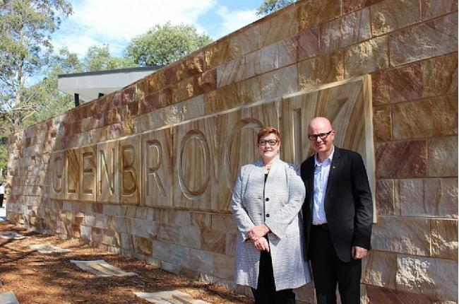
In 2018, Council prioritised spending $1.4 million to upgrade the Glenbrook Visitors Centre. Half was out of ratepayer funds and the other half from Canberra. It was supposed to boost tourism to the Blue Mountains. Problem is hardly anyone visits the centre because Glenbrook has become outer Sydney by both urban sprawl and electoral boundary.
But it is in Mayor Mark Greenhill’s ratepayer Ward 4.
In 2012, Lennox Park in Glenbrook was upgraded at a cost of $50,000. In 2022, Council secured $1.2 million to upgrade the following parks in the Blue Mountains:
- $1 million for Mount Victoria Memorial Park
- $100,000 for Glenbrook Dog Park
- $100,000 for Leura Dog Park
Between 2018 and 2020 Blackheath Soldiers Memorial Park received $1,391,962 from Council funding.
In February 2023, Council secured funding of $60 million from the NSW Government’s WestInvest Community Project Grants programme. Council is spending it on the following:
- Katoomba Town Centre – Place Activation Project ($7.5 million) more pebblecreting – (“pebblecrete it and they will come”) and public art
- Neighbourhood Park Upgrade Program ($6.1 million)
- Great Blue Mountains Trail – Kiah Lookout to Echo Point ($5.6 million)
- Upgrade of the Katoomba Falls Visitor Precinct ($4.6 million)
- Glenbrook Activation and Improvement Program ($4 million)
- Development of Improved Visitor Facilities Infrastructure to Support Tourism Recovery ($3.5 million)
- Pitt Park Athletics Complex Upgrade ($3.4 million)
- Blaxland Activation and Improvement Program ($3.3 million)
- Active Transport Link – Single Ridge Road, Winmalee/Yellow Rock ($2.6 million)
- Great Blue Mountains Trail – Narrow Neck Road to Acacia St, Katoomba ($2.2 million)
- Hazelbrook Village Centre – Place Activation Project ($2.1 million)
- District Park Upgrade – South Lawson Park ($1.6 million)
- Community well-being – Solar and batteries ($870,200)
- Revitalisation of the Wentworth Falls School of Arts Theatre and Hall ($649,863)
What about revitalising Megalong Road so people can actually access the Megalong (and not via Little Hartley?
Why does Council treat Megalong folk as second class ratepayers? When was the last time a Blue Mountains Councillor lobbied to have Megalong Road properly remediated, starting with fixing the landslips?
Indeed, when was the last time a Blue Mountains Councillor actually visited the Megalong?
Why does Council refuse to employ a permanent Hydrologist?
We just don’t want to hear government talking about resilience classes for residents. Resilience ought to have been in the duty of care Blue Mountains Council should have displayed by fixing this known risk.
Blue Mountains Council does not employ a permanent Hydrologist or Geotechnician.
Why not Mayor Mark Greenhill? What is the hydrological and geological characterstics of the Blue Mountains?
The Blue Mountains are geologically characterised as extensive raised plateaus on sandstone which receive a high average of 1050 mm rainfall a year, and frequently in torrential volumes over days during East Coast Low events during periodic La Niña climate cycles.
Reactively, Blue Mountains Council calls in a consulting geotechnician from some Sydney firm after the fact, after a landslide that has caused a disaster. But it refuses to gainfully employ an hydrologist or geotechnician on its permanent payroll. Why?
Yet how many landslips has the Blue Mountains region copped over the past decade and in years prior? More than dozens. And how much economic cost have these had on local businesses, or Blue Mountains tourism and the immeasurable impacts on people’s livelihoods? Does Council even measure these impacts?
Council needs to start thinking proactively, not reactively. It would get more brownie points from ratepayers by averting disasters that it mischievously terms “natural disasters”. Instead, they are another case of government wanton neglect, allowed to fester and morph into compounded disasters.
Megalong Road – a Council ‘stop and go’ neglect for decades
Lithgow Council hasn’t learned any lessons in this regard. We thought Blue Mountains was a tad wiser.
We’re not talking about Council hiring a junior casual on intern slave wages. We’re talking about it appointing a permanent senior Hydrologist with a Geotechnician with a qualified support team of about half a dozen staff.
This new department, perhaps ‘Blue Mountains Hydrology’ will need dedicated adequate funding to enable it to do its job properly year-round. Active and constant grant funding applications will need to supplement their vital work. Local community engagement of a regular basis will be vital as well, since the locals inevitably know the priority infrastruture needs better and sooner than government and its bureaucrats.
The adjoining Parks Service could well do with their expertise as well. Based them at Council new Centre for Planetary Health in Katoomba, strategically located in the upper Blue Mountains and a 5 minutes drive from Council Chambers!
In November 2023, Council publicised a management summary report entitled ‘Megalong Valley – Natural Disaster Recovery Update‘.
In that report, it highlighted community concerns and issues of Megalong folk about repeated landslips closing Megalong Road. The substandard quality of Council’s outsourced civil contractors was emphasised as well as the decided absence of Council supervision of the ongoing works.
“The (Megalong) community raised seven main issues raised with councillors that were:
- Project planning & priorities.
- Concerns about the lack of funding
- Seeking assurances that the road will be safe and accessible for emergency services during the next fire season.
- Quality of contractors & the work undertaken and the supervision/management of contracts by Council.
- Short term work on the most problematic parts of the road, asap
- Timetable for grading and maintenance of the road network
- The issue of the remaining traffic lights.”
Kicking and screaming after at least two years (2021-2023) of Megalong community’s expressed frustration, Blue Mountains Council finally appointed stated communicating with them, and appointed a dedicated civil engineer, one Muhammad Ehtisham, to oversee this Megalong Road reconstruction project including the remeduiation of various landslips along the road.
This is Council’s related report of November 2023:
 Loading...
Additionally, a Project Management firm was also engaged to help with the landslip remediation.
Council Diddly-Squat: Is Council’s neglected Shipley Road next to cop its known ‘Landslip #10’ ???

Hypocrisy
References:
[1] ‘Landslide destroys Megalong Valley road, leaving Blue Mountains community stranded‘, 9 April 2024, by Freddy Pawle, Dality Mail Australia, ^https://www.dailymail.co.uk/news/article-13285987/Landslide-destroys-Megalong-Valley-road-leaving-Blue-Mountains-community-stranded.html
[2] ‘Blue Mountains community cut off after landslide destroys road to Megalong Valley‘, 8 Apr 2024, by Lani Oataway, Hugh Hogan, and Hamish Cole, ABC Central West, ^https://www.abc.net.au/news/2024-04-08/megalong-valley-landslide-nsw-community-isolated/103680676
[3] ‘$76 million for landslip recovery approved by Blue Mountains City Council‘, 18th April 2023, by Tom Walker, ^https://www.bluemountainsgazette.com.au/story/8156571/76-million-for-landslip-recovery-approved-by-blue-mountains-city-council/
[4] ‘Essential roadworks cuts off the Megalong Valley for three nights‘, 10th October 2022, by Brenda Cunningham-Lewis, Blue Mountains Gazette, ^https://www.bluemountainsgazette.com.au/story/7931811/megalong-valley-cut-off-for-essential-night-roadworks/
[5] ‘What is the History of Megalong Road‘, published 18 June 2021, ^https://www.askroz.com.au/blog/Q&A/what-is-the-history-of-megalong-valley-8506/
[6] ‘Megalong Valley businesses cut off by road damage, drop in business more than halved‘, 20th September 2022, by Brenda Cunningham-Lewis, Blue Mountains Gazette, ^https://www.bluemountainsgazette.com.au/story/7884246/we-dont-want-to-become-a-ghost-town-megalong-valley-facing-100m-road-repair-bill/
[7] ‘For the second time in four months some Megalong Valley residents have been cut off from the rest of the world due to heavy rains and flooding‘, 8th July 2022, by by Brenda Cunningham-Lewis, Blue Mountains Gazette, ^https://www.bluemountainsgazette.com.au/story/7762765/megalong-valley-woes-continue-in-flooding-event-50-metre-zipline-set-up-for-emergency-supplies/
[8] ‘Evacuations and emergency food drops at Megalong Valley after landslide‘, 8th April 2024, Blue Mountains Gazette, ^https://www.bluemountainsgazette.com.au/story/8584439/landslide-in-megalong-valley-evacuation-update-from-council/
[9] ‘Megalong Valley releases new app to report natural disasters, inform local community‘, 7th July 2023, by Tom Walker, Blue Mountains Gazette, ^https://www.bluemountainsgazette.com.au/story/8243874/megalong-valleys-new-natural-disaster-app/
[10] ‘Megalong Valley – Natural Disaster Recovery Update – November 2023‘, Blue Mountains Council, ^https://www.bmcc.nsw.gov.au/major-projects/megalong-valley]
[11] Megalong Valley Community and Landowners Association Incorporated, ABN 39 425 588 904, Active from 23 Jul 2019, ^https://www.facebook.com/groups/megalongvalleynsw/
[12] Greater Sydney Dam Levels, Water NSW website, ^https://www.waternsw.com.au/nsw-dams/nsw-storage-levels/greater-sydney-dam-levels
[13] ‘Council Opens New Glenbrook Visitor Information Centre‘, 4th December 2018, media release by Blue Mountains City Council, ^https://www.bluemts.com.au/news/council-opens-new-glenbrook-visitor-information-centre/
[14] ‘$60 million in WestInvest projects for Blue Mountains‘, 10th February 2023, ^https://www.bluemountainsgazette.com.au/story/8081021/60-million-in-westinvest-projects-for-blue-mountains/